iNavX
Application: iPhone, iPad, iPod Touch
Function: Charting and GPS navigation
Cost: $49.99
Rating *****
 Whether your a weekend boater or a coastal cruiser you will appreciate this application on your i-thing. The iPhone and now the iPad have put computing, GPS, charting and navigation in the palm of our hands. The use of these devices and apps as the primary source of navigation on boats is still up for debate. This app has gone a long way in reaching that goal.
iNavX is in my opinion the most full featured application for charting and tracking your position while underway on the water today. The author has done a nice job displaying the charts and integrating soft keys to access the main menus. iNavX updates the product regularly and they continue to add functionality and new features.
The charting display shows a navionics chart with access to charts, waypoints, tracks, instruments and forecast data through the use of softkeys at the bottom of the screen.
Features:
 It allows addition of waypoints, routes, tracks and has a full compliment of displayable instruments.
- iNavX can communicate with your favorite marine navigation software. Through your WiFi connection, NMEA data can be transmitted over TCP/IP to the iNavX app. Support is included for GPS, AIS and numerous instrument types.
- The application works with the third party Dual GPS cradle.
- I have used GPSGate and Polar Com to transfer GPS and other NMEA data to the application via TCP/IP.
- The application uses the built in locations services feature of the iPhone, iPad and iTouch.
- It uses charts that you purchase through X-Traverse. Available charts types are CHS Canada, Navionics Gold, Fish'N'Chip, HotMaps, NV. Verlag, Hilton's Fishing, TRAK Canada lakes fishing charts and Solteknik European waters charts.
- NOAA charts, similar to your paper charts are free to download with the X-Traverse account.
- GRIB weather data files can be downloaded through your X-Traverse account.
- Download it from iTunes and give it a try!

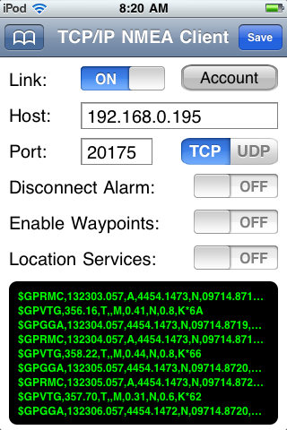 One thing that sets iNavX apart from the other charting apps is that you can connect your ships instruments to the app through TCP/IP. This feature give you access to all the NMEA data on your boats network. I have found no other charting app that offers this feature.
Simply add your host IP address and port number and select TCP or UDP. Once the Link button is selected the NMEA data starts scrolling shown in green.
Several different setups can be saved and bookmarked for later use.
Pros: I found it to be full featured and very easy to setup and use. The iNavX website offers help and answers to many FAQ.
Cons: It is a little pricey compared to some other charting apps. Charts need to be purchased separately in addition to the app.
iNavX upgrades to 3.2.5
Rich Ray at iNaX continues to take request for additions to his popular app. He has recently added notification when a waypoint is activated either manually or automatically. The alert will will display the waypoint name.
One request that I made and I assume others did also was to have the instruments displays in digital format instead of the original speedometer looking gauges. Rich did a good job in this application. Simply go to Preferences and select Instruments. There is now a selection for digital only.
A "More Detail" selection is now provided for the Navionics charts. This will show a list of objects near the location where you tap on the chart.
UDP support has been added in the TCP/IP NMEA Client Setup. Go to preferences and TCP/IP NMEA Client. There is now a setting to toggle between TCP and UDP.
Navionics Region 1XG, 35G 2011 editions.
Great job Rich, keep up the good work. We are all loving iNavX!
Can anyone explain how to disable INavX preset to constantly return to home page every 15 seconds?
ReplyDeleteThanks a million!
Peter
Peter,
ReplyDeleteWelcome! Thanks for checking out the site.
I am not quite sure what your asking. Can you give a a little more info about your problem. Are you navigating to a waypoint or route? Are you viewing a chart? What homepage is it returning to.
Mark
I was planning to purchase the third generation iPad, however I could not determine if the INavX software runs on the newest iPad. Anyone know if the INavX software will run on the newest iPad, which is the third generation iPad that has only been on the market for a few months.
ReplyDeleteThanks for any help on this.
Chad
Chad,
ReplyDeleteGreat to hear from you, hope you are enjoying the blog. I checked around and there are people using the new iPad with iNavx. Check out the MacSailing Forum if you have specific questions. Alot of user there with great feedback.
http://www.macsailing.net/fbb/showtopic.php?tid/1696/
Thanks for stopping by. Become a follower or click on a few Google adds to support the site.
Mark
Can the iPad3 be used with iNavX as a stand alone navigation device? I just got one as a gift, I do coastal cruising on a 25' and have no other navigational tools other than charts. I would love ot be able to enter waypoints and just track on them, is this possible?
ReplyDeleteMoose,
ReplyDeleteYou bet, it is perfect for that! I am glad you found by blog and hope you find it helpful.
iNavX is a great app and there are others that might work for you also. Check out my Best Marine Charting apps at this link,
http://i-marineapps.blogspot.com/p/best-marine-charting-apps.html.
They are all fairly inexpensive and do a good job. I own and use several.
There are weather apps, tide apps, AIS apps and data display apps. Using the iPad and iPhone for Marine use is what this blog is all about. Become a follower and check back often for more great marine app reviews.
~~~Sail On~~~
Mark
Ok, so understanding that I am a total none computer kind of guy, I download the iNavX program, there's a GPS chip in the iPad3 that works like it woudl on a Garmin, and I'll be able to do chart plotting for simple coastal cruisng, right? Do I need to start the data plan to do that? Is it dependant on cell towers for triangulation? Sorry for the questions, I'm just lame at this stuff considering how much I sail.
DeleteMoose
It sounds like you have the new 4G version of the iPad. That is good because that model has a GPS on board, the WiFi only units do not have GPS.
ReplyDeleteYou do not need to activate the cell data plan. The GPS will work independently of that.
iNavX is a little more work to get set up and download charts. If you go that route follow my tutorial on iNavX.
http://i-marineapps.blogspot.com/p/inavx-tutorial.html
As a newby you might consider the iSailor app, download the app for free and then buy charts from $5 to $9 for your area. iSailor has upgraded and now lets you do waypoints, routes and tracking.
Good luck.
Mark
Let me know how things turn out.
Moose,
DeleteDo you sail on coastal waters or inland lakes? I will matter what app you purchase.
Mark
Moose,
DeleteAnother app that you might take a look at is SEAiq. It is only $9.99 and has free charts. I recently reviewed it here.
http://i-marineapps.blogspot.com/2012/04/seaiq-intelligent-vector-chart-plotter.html
Mark
Mark,
ReplyDeleteI am wondering if some of the i-ware apps will be supporting direct integration for 3/4G radar. I would like to skip buying a chart plotter all together and just directly integrate the systems to my ipad.
Greg, s/v Blue Sky
Greg,
ReplyDeleteThanks for your comment and welcome to the site. Hope you become a follower and share the blog with your friends.
That is a great idea! I am not aware of any apps that will do it directly. If you can get the Radar to your PC an app called Splashtop will mirror your PC's screen to the iPad.
Systems like Raymarine with their Rayview app will allow you to do it but you have to buy an expensive Raymarine chartplotter too.
It is only a matter of time before someone figures it out. Stay tunes!
Mark
Hey Mark, does inavx run on android? Also I've a bluetooth nmea multiplexer onboard so would like to run chart software on a samsung tablet linked via bluetooth to ships instruments and nmea ais feed. What do you think? Kind regards Colin
ReplyDeletewww. Yachtemerald.com
Colin,
ReplyDeleteGreat to hear from you! iNavX does not run on Android, sorry. Most of the great charting and NMEA apps run on iOS.
iRegatta is one NMEA app that will display instrument data on an Android device.
https://play.google.com/store/apps/details?id=dk.letscreate.aRegatta&hl=en
There are others too, just search the GooglePlay store.
Mark
What kind of features are not available if you don't have internet connection on your iPad?
ReplyDeleteSebastian,
ReplyDeleteWelcome. iNavX was built to work while not connected to the internet. All charts are downloaded to the device so they will work while at sea. All navigation functions like routing, waypoints, tracks, points of interest and the instruments work too.
I believe the weather data and GRIB files download does require that you have access to the internet to download.
Mark
iNavX does not support quilting (automatic loading and management) of raster charts. This is found in other apps. It makes chart management difficult.
ReplyDeleteThanks for your blog Mark - a great read and really helpful. I was wondering if is possible to save all my waypoints from a lowrance combo to data card and then import to this app??
ReplyDeleteMany thanks,
Al.
Allan,
DeleteiNavX requires that the imported files be in the GPX, KML or KMZ file formats. If you can get them into an email you can use the "Open In" option to import them into the app. I am not sure what file format Lowrance uses. You can also import them using your Xtraverse account. http://www.inavx.com/help/waypoints.htm
Good Luck.
Mark
I downloaded and paid $49.95 for iNavX on my i Phone.
ReplyDeleteI then downloaded a chart for the Fort Myers area: Straights of Florida.
It was great,,it showed channel markers etc,,,now the channel markers are gone.
All I see is my position.
Ron
Ron,
DeleteIn the charts display, select the gear(settings) icon in the upper right of the display. This brings up the chart settings. Make sure the Show Navaids and Show Light sectors are set to on. If this does not work try powering down your iPhone and restarting, or delete the app and reinstall.
Good Luck!
Mark
It
Does connection thru TCP/ICP mean that you can connect an iPad mini, via a ship's pilot plug, to the course, speed and AIS data from the ship's gps and radar?
ReplyDeleteiNavX allows the user to connect through WiFi using either TCP/IP or UDP protocols. Check out the iNavX website for recommended devices. http://www.inavx.com/
DeleteGood luck
Mark
Mark,
ReplyDeleteThanks for your help in the past. My friend has been running the navionics app on her ipad for some time but has just seen the InavX and purchased it. Does she have to buy the same charts again through X-traverse or is there someway of getting them in from the Navionics app????
Many Thanks,
Al.
Al,
DeleteUnfortunately there is no way to use the Navionics charts in the Navionics app for the iNavX app. You will have to buy another set from the x-Traverse website. This is one drawback with iNavX. See their page of FAQs http://www.inavx.com/#FAQ.
The raster paper looking charts are free to download within the app. The vector charts sets like the Navionics charts you will have to pay for.
Good Luck
Mark
I would like to use .bsb (raster) charts that a friend setup using Costal Explorer, and "import" them into iNAVx...is that possible? I already copy them to my dropbox folder and uploaded them into my IPaid air...
ReplyDeleteThis site is the best!...You really rock!
(do you provide direct help?, I would be more than happy to pay you if you help me to get started) I have an AIS + GPS Plug, Aipad Air, and I´m planning to purchase iNavX, but only if i can use my own charts, they are quite unique)
Yamandu,
DeleteWelcome to the site and thanks for the question. A lot of people hate the fact that they have to keep buying charts for each app they own. Unfortunately iNavX is not different. I have searched for a way to import charts into iNavX but cannot find a way to do it. That means you have to download the raster .bsb charts. You will need a xTraverse login and account to do that.
I do know a great app called SEAiq Open International for $39.99. It is just as full featured as iNavX and it will allow you to import your charts into the app through Dropbox or email. You can even try it for free to make sure your charts download ok before buying it.
I have written about SEAiq extensively and it is #2 in my top 10 for marine charting apps. Give it a try and let me know if it works.
https://itunes.apple.com/us/app/seaiq-open/id529514298?mt=8
I do accept donations if you feel that I have helped you out. Click the Support i-Marine Apps menu selection above and donate through PayPal.
Also if you find any of the Google links interesting click on them to support the site also.
I appreciate any support, thanks and good luck!
Mark
Yamandu,
DeleteMake sure to become a follower of the blog to keep up on the latest and greatest marine apps.
Mark
This comment has been removed by a blog administrator.
ReplyDeleteWill this program track other vessels like rosepoint?
ReplyDeleteWill this program track and display meeting situations such as Rosepoint?
ReplyDeleteJack, thanks for the question and welcome to the blog.
DeleteI think you are asking about display of AIS targets of other vessels. Yes, iNavX does have the capability to display other vessels using a separate AIS receiver on board your boat. You will need to supply the AIS NMEA data over WiFi to the iNavX app. The iNavX app will display all AIS targets on the displayed chart. CPA, closest point of approach calculation are made to determine if you are on a collision course with any of the targets. I hope this is what you were asking about, if not please give more detail in your question.
Stop back soon and become a follower to keep up on the latest posts.
Mark
Hi Mark,
ReplyDeleteI've bought an IPAD (with GPS) specifically as a navigation aid in a small open boat. But I'm useless at technical stuff and don't want to download the wrong thing. Would really appreciate your advice on the below questions!
- Do I need to download iNAVx first or the charts?
- Will iNAVx, with the charts, show my position in lat/long as well as indicating it on the chart? If so will this be in WGS84 format?
- Does iNAVx have tidal data in it? Will it calculate a course to steer? If not is there something else that will?
- Will iNAVx give me predicted tidal height data for a given location at a given time of day? Will it do so in advance?
Thanks, and great site!
Dave
Dave,
DeleteWelcome! If you read through the users manual and the tutorial on this site, I tell you exactly how to get started with iNavX. You will need to buy the app first and then set up an account in xTraverse.com. This is where you buy the charts. You have to buy them on xTraverse, no other charts will work.
iNavX will track your position in real time on the charts and display it on the instruments bar on the top of the screen. It does use the WGS84 datum.
Tide data can be viewed in the app with the purchase of AyeTides. See the AyeTides site for all its features.
It will calculate a course to steer to any waypoint. If wind and tides affect the course iNavX will calculate a cross track error XTE and correct your course accordingly.
iNavX is a leader in the Marine Navigation App arena. I still have it rated as number 1 on my list of top 10. Check out others marine charting apps to make sure you want to invest in iNavX.
Good luck
Mark
Thanks, that's really helpful.
DeleteIf I get the charts through xtraverse, are they also compatible with the navionics app?
No the xTraverse charts will only work with the iNavX app. They will not work with the Navionics app.
DeleteHi Mark,
ReplyDeleteThanks for all the information!
I am having trouble finding out about wind direction and strength & tidal current direction and velocity. Are these displayed on the iNavX when underway? Do you have to have separate apps for this information and if you do will it display it on the chart for you or do you have to open a separate app? If additional apps are needed do you have suggestions? A saw Theyr has the information by will it overlay the info for you?
Thanks! Kirk
Kirk,
DeleteWelcome, great to hear form you! Check out my post about iNavX and Theyr weather.
http://i-marineapps.blogspot.com/2012/12/inavx-361-introduces-theyr-weather.html
Here is another link from the Fugawi website.
https://fugawi.com/knowledge_base/document/IX14302
Another from the xTraverse website
https://x-traverse.com/product/XT-THEYR-PRE-MB-365
Mark
This comment has been removed by a blog administrator.
ReplyDelete