Wednesday, September 26, 2012

LifeProof iPad Case

I have been in search of the perfect iPad case since I bought my iPad 2 several years ago. I have considered the Scanstrut, Griffin, Otterbox and a strange vinyl bag that zips shut.  Most of them seemed to bulky and covered up the functionality of the iPad.  I was searching for "nirvana", the holy grail, the perfect case that I could take out in the rain, snow, dirt and even underwater.  Had I finally found "the one" to keep my little baby protected and dry.

I have owned a LifeProof case for my iPhone for over a year now and have been very happy with its performance.

The new LifeProof case for the iPad was released recently and is called the "nuud" a little play on words.  It is called nuud because the iPad screen remains completely uncovered while the rest of the device is encapsulated in a waterproof case.

I kind of questioned if this case would protect my iPad. There are two large o-ring seals, one for the front facing glass and one to connect the two pieces of the case together.  I pored over the LifeProof website, analyzed the specs and watched a bunch of YouTube videos and became convinced that this might be a great case.  I have not ordered one yet, but if the quality is as good as my iPhone case it may be worth the $129 price tag. For $149 you get the the plastic cover and stand too.

Features:

  • Dimensions: 10.4in x 8.2in x 0.8in / 265mm x 208mm x 20.5mm
  • Weight: 0.7lbs / 310gms
  • Water Proof: IP068 Standard. Fully submerge to 6.6 feet / 2 meters for 30 minutes
  • Shock Proof: Military Standard 810F-516. Designed to withstand drops from 4 feet / 1.2 meters
  • Dirt Proof: sealed from dirt and dust particles to the IP-68 rating
  • Snow Proof: Keeps out all snow and ice to the IP-68 rating
  • Patent Pending speaker opening
  • Waterproof Ear bud adapter
  • Fully functional Home button, mute button, volume control
  • Accessible charge port
  • Double AR coated glass port for the rear facing camera
  • Transparent back
The specs and the videos speak for themselves. If you want the best case with the best protection for your iPad, this is it.  The case is not cheap at $129 but look at it as a insurance policy. You won't have to worry about damaging your iPad ever again.

The installation instructions seem long and complicated. There are all these orange warning stickers to check this and check that. You must do a water test! All the reviews say to read and follow all directions or you will have leaks. LifeProof puts out quality products and I am not scared of a few orange warning stickers.  My order is going in soon.

Give me some feedback, does anyone have one of these, do you Love it? Hate it?

~~~Sail On ~~~ /)
Mark

Tuesday, September 25, 2012

Delorme Earthmate

Application: iPhone 3,4&5, iPad, iPod Touch 3,4&5 gen
Function: Satellite messaging and tracking
Rating: *****
Cost: Free


The Delorme company has been in the GPS navigation and mapping field for many years. This US based company has it's headquarters in Yarmouth, Maine.  One of their hottest products to date is the inReach satellite communicator. The inReach allows you to stay connected anywhere in the world. 

Traditional cell service can only be had over about 10% of the world.  With the inReach, the other 90% also becomes your playground.  Any smartphone or tablet can run their Earthmate, IOS or Android app that pairs with the inReach to provide texting and messaging worldwide.  Now, your average person is not going to need messaging capabilities in the Southern ocean or the Himalayan mountains, but if you do, this setup is the cat's meow! 

I am thinking of all you world cruisers out there that are out of cell range most of the time.  Satellite phones are an option but come with a hefty price tag.  The inReach/Earthmate combo is a more affordable options that might fit your needs.

The Earthmate app is the interface between the inReach satellite transceiver and the user. It comes in both Android and IOS versions and allows you to send and receive messages, track your progress on charts and maps and has the ability to send out emergency distress calls if needed.

There are other devices out there like the SPOT communicator.  The SPOT however lacks world wide coverage and has some drawbacks but may suit your needs too.  The SPOT runs about $100.00 while the inReach runs about $250.00. Both devices will require some kind of service plan for satellite communication.

The inReach communicates with the worldwide Iridium network of 66 satellites orbiting the earth. If you are interested you can track them at this website.

Features:
  • Connects the inReach to your smartphone, tablet or iPad wirelessly via Bluetooth
  • Post your location to social networking sites
  • Compose email or SMS messages from your phone contacts
  • Uses the Iridium satellite service
  • Compose and send messages up to 160 characters
  • View incoming messages
  • Post to Facebook, Twitter, or your own shared map
  • SOS Alerts
  • Provide text information for emergency responders
  • Send status updates on your situation
  • Automatic track location
  • Select tracking intervals of 10 minutes to 4 hours
  • GPS position accuracy within 5 meters
  • View tracks of your position online 
  • Navigate with DeLorme Topo North America maps, DeLorme Digital Atlas of the Earth maps or NOAA Charts
  • Downloaded maps are used outside of cell range
The apps is pretty straightforward. The first screen you will see has selections for Map, Messages, Tracking, History, SOS and Options.

The app requires that you have purchased an inReach 2-way satellite communicator to use any of it's functions. So shell out that $250 and lets get started. You will need to activate your unit at explore.delorme.com and set up an inReach account. There is a one time activation fee of $19.95.

The account will allow you to add contacts to your address book. The adresses are then assigned a 2 digit code to reduce the data sent in a message.  You will have your own MapShare page that will show the tracks of your adventures. You can share this page with your friends and family.  They can even send the inReach unit a location request to find where you are in real time.

The inReach unit can then be paired via Bluetooth to your smartphone or tablet using the Earthmate app. Press and hold the inReach power button until the LED starts double flashing. On my iPad the Bluetooth setting are under Settings/Bluetooth.  This pairing process only needs to be done once. The next time you power the unit on it will automatically connect.

Maps

The Map Layer Mangement selection will allow you to download NOAA charts of North America or detailed Delorme topographical maps.  Different map sets are managed under the Map Library. Here you can download and delete your maps. Data Management is used to control the layers of the map details. 

On screen you will notice the GPS Location Arrow. The solid green indication shows a good GPS signal, Yellow is acceptable and Red means no GPS fix at all.

The Map Rotation Arrow in the top left of the screen allows you to control map rotation. You can tap this to toggle between north-up or direction of travel modes.

At the bottom of the screen you will see a gripper bar. Tap to pull this up to display data fields.  These can be configured to show one or two rows of data including, speed, elevation, coarse and GPS coordinates.

Messages

Messaging is a very important feature of the Earthmate and inReach setup.  Email messages and SMS text messages can be sent and received through the Earthmate app. The message list will show all your conversations sent and received. All threads of the conversations will be kept. Tap a conversation to respond directly to the text.  Your sent text messages will include a link to a map of your location.

All outgoing emails will also include a link to a map of your location and can be responded to via the website.  The number of messages you want to send will be determined by what service plan you select.  A plan of $24.95 per year gets you unlimited inReach messages and tracking points but only 40 text messages.  So make sure your son and daughter know this is not like your normal texting plan. Overage charges add up in a hurry.


Monthly Billing PlansSafetyRecreationExpedition
SOSYesYesYes
Text MessagesSee Below*40120
inReach MessagesSee Below*UnlimitedUnlimited
Tracking Points$0.25 ea.UnlimitedUnlimited
Monthly Charges
Annual Subscription$9.95$24.95$49.95
Seasonal SubscriptionNA$39.95$64.95
Overages
Messages (each)$1.50$0.50$0.25

Tracking

Another powerful feature of the inReach and the Earthmate app is the ability to provide tracking information to friends and family via the explore.delorme.com website. The tracking points can be sent at a variety of intervals.  Go to Options/Tracking interval to decrease the interval rate to conserve battery life.

To start tracking tap the Start button. Your tracking points will display on the chart as they are sent. The inReach unit will continue to send the tracking points even when the Earthmate is turned off.  The next time you open the Earthmate app it will show the updated tracking points.  Tap the Share button to send a message including a link to your tracking page.

History

The History feature is an archive of all your tracks and point data.  The data is organized in a chronological list for the days with tracking history. Tap the On/Off button for a day to show the track points recorded.  Select the Action button to hide or show all days in History.

Each point can be selected and the data for that point can be viewed, forwarded or deleted. This is a convenient way to review all of your travels and the exact tracks you took.

I am very impressed with the inReach hardware and the companion Earthmate app. The combination of these two puts a powerful tool in your hands.  Your loved ones will never have to worry again because they will know exactly where you are.  You have the ability to chat with them from anywhere in the world. How cool is that?

If your looking for a reasonably priced setup that will give you the ability to keep your friends and family updated on your travels and summon emergency assistance if needed, check out the inReach and the Earthmate app. 


~~~Sail On~~~ /)
Mark


Saturday, September 22, 2012

Transas iSailor Release 1.5

The developers at Transas Ltd. have been busy since I first reviewed the app in January 2011. The recent release of version 1.5 has updated the iSailor app with a whole new interface for creating and editing Waypoints, Routes and Tracks.  The previous versions fell short of giving the user full functionality in creating and editing waypoints and routes. The old interface was one of the reasons I found it cumbersome to use.  I am glad to see that they have addressed these issues and are still working to improve the app.

I have always been a big fan of their charts!  I find them very bright, colorful and easy to view.  The addition of the new features have encourage me to take another look at using the app. 

 Recently added features
  • Multi-layer Waypoint, Route and Track creation and editing
  • ETA and XTE data 
  • Fuel consumption
  • Import/export to various format for routes and tracks
  • Electronic Bearing Line referenced to a position
  • Cursor location tool
  • Track recording
  • Enter coordinates for waypoint and other points of interest
  • Users Guide
The new splash screen shows some of the new features that have been added.  The three bubbles allow you to move between the different layouts or layers.

The Cross hairs are for the new locator tool. A new point of interest icon is used to add user data to the charts.

The Flag icon is used to create waypoints for routes.

The Arrow icon let you turn on the electronic range and bearing tool.

The Info icon can be tapped to edit and delete route and track details.

This splash screen can be turned off in the settings screen once you get familiar with the new features.

The locator tool is a neat function that provides multiple functionality. If it is not shown on the screen simply long tap with your finger on any location and you should see the cross hairs appear. 

Take your finger and move the center of the cross hair around the screen.  The latitude and longitude will appear in an orange bubble in the top left of the screen.

A single tap on the cross hairs will show chart information located at the cross hair location. Tap and hold on the cross hairs to make the tool disappear.  A long tap anywhere on the chart displays the locator tool again.

Tap the chart with a second finger while dragging the cross hairs to switch on the electronic Range and Bearing tool. I found it easiest to use my index finger and my thumb  As you move the second finger around the cross hairs, note the range and bearing from the cross hairs location shown in the orange bubble on the top left of the screen.  Simply long tap the center of the cross hairs to turn it off again.

The three bubbles at the bottom of the screen are hard to find at times.  They seem to blend in with the chart data if the chart is lightly colored or busy.  The bubbles allow you to select the different layers for creating and editing waypoints, points of interest and routes. 

The first bubble only shows the chart and any route that may be selected.  The second bubble allows the addition of user points of interest.  User points of interest can be added to the chart for your personal reference.  The point can be renamed, given a depth and detailed info for rocks obstructions, buoys, beacons or other facilities can be added to the point.

To create a POI, just place your finger on the the POI marker and drag it to the position you want it. As you move it you will see the latitude and longitude in an orange bubble in the upper left of the screen.

Overlayed Waypoint and Course displays are shown on the top of the screen. These show the course and distance along with cross track error and estimated time of arrival. This information is to the first waypoint in the selected route.  Location coordinates and course and speed are show in the upper right.

The last layer allows you to add, edit, delete and save routes, waypoint and tracks. If no routes exist you can create one by tapping on the + button in the routes section on the top. To add waypoints to your route, put you finger on the red waypoint flag and drag it onto the chart to create your first waypoint. At this time you can rename the waypoint if desired by tapping the waypoint and typing in the name. 

Continue dragging new waypoints onto the chart to create your route. You will notice a handy distance and bearing indication from the previous waypoint as you drag the new waypoint to it's desired position.

Once the route is competed you can select the route or select the italicized i next to the route to see the route info and waypoints. Total route Distance, ETA and fuel consumption are calculated.  The cruising speed and fuel consumption can be set hear also.

Tracks can be started and stopped from this layer also. Select the Start Track Recording button to initiate recording. Select  it again to stop. Select the italicized i next to the Track to display the start, stop, duration, distance average speed and points of the track.  You can delete any of the tracks here also.

The last feature gives you the ability to export your Routes and Tracks in GPX, KML and KMZ formats.

Simply select the route or track to export and select the file format.  The app gives you the ability to save to iTunes, email it or send it to Google Earth, iNavX, Weather 4D, Dropbox or any other compatible app. 

I am very impressed with the latest additions to the iSailor App. The additions have improved the user interface immensely and created a more full featured app. 

The app is free, yes free! You know how much I like free.  The charts are downloaded by in-app purchases ranging from $4.99 to $39.99 depending on which chart package you need. 

Sunday, September 16, 2012

Navionics Nav Module

Many of you boaters should be familiar with the Navionics Corporation.  They are a world leader in marine electronic navigation applications and detailed marine charts. I have previously reviewed a few of their popular charting apps.

They have just launched an In-App Purchase of the Nav Module to enhance it's award winning Navionics iPhone and iPad HD Applications. 

The module can be purchased for $1.99 under the Upgrades and Apps section of the menu.   

The Nav Module was developed to enhance the routing experience of the Navionics Apps.  It provides the user the ability to easily enter routes and analyze distance and heading to the next waypoint.

Additional waypoints can be added to create and save routes. All routes are saved to the Route Archive. Routes can also be reversed so you can track back on the route you just followed. 
Waypoints are easily added to the chart by simply tapping on the a location. Continue tapping to add additional waypoints. Hold your finger on a waypoint to adjust it's location or delete it.

A route can be made up of one or several waypoints. Use the crosshair X to select the starting point for your route.

Additional intermediate waypoints can be added to a route by simply tapping the route segment.

You can create up to 99 waypoints per route on the map and save up to 1000 routes.

Banners at the top show you the present leg of the route, the time and distance to the end of the route.

Select GO to follow the route.
Additional route details show your estimated time of arrival, distance to arrival, heading to waypoints and fuel consumption.

To set the cruising speed and fuel consumption, tap on the blue settings in the lower right of the display. You can select between km/h, kts or mph.

Fuel consumption can be selected as either liters or gallons per hour.

Editing can be done underway while receiving real time route data.  Routes can also be planned off the water and synced to your other mobile devices.

The Nav Module is a great addition to the Navionics line of apps.  Purchasing it for only a couple bucks provides you with many cool features and data.  Let me know if you think it is worth it?

Take a Boating Survey!

All of us in the marine industry have quickly adopted the use of the smart phones and tablets to aid us in navigation.  My blog has attempted for the past two years to try to inform you of the best marine apps on the market. I hope I have made your time on the water safer and more enjoyable. 

There are others in the marine industry that are interested in what apps boaters are using.  You can help these folks understand what apps you find useful and what features you like and don't like.  There is a survey out there on the Survey Monkey site where you can share what devices you use and what apps you find most useful.

I just took the survey and it only takes a few minutes to answer about 23 questions. The folks at Electric Pocket are doing the survey.  They are the same great people who have developed the Boat Beacon and Compass Eye apps that I have reviewed earlier in this blog.

Make sure to enter your email at the end for a chance to win a Boat Beacon or Compass Eye app!

Survey link:
https://www.surveymonkey.com/s/boating_apps

Once the survey is complete they will post a link to the results. I will pass along the link to everyone at that time. There should be some interesting results from the survey. App developers might be interested in the results also.

Have a great week!

~~~Sail On~~~ /)
Mark

Sunday, September 9, 2012

Fishpoints Marine Navigation

Application: iPhone, iPad
Function: Marine Charting and Navigation
Cost: $8.99
Rating: ***

I ran across another marine charting app the other day and with the help of the author Marco Palaferri I was able to take a closer look at his app called Fishpoints Marine Navigation.  This version is called Fishpoints Amerigo and is more related to marine navigation on the iPad. He has other versions including Android versions for smart phones. You can check them all out on his webpage. His website is also very helpful in becoming familiar with using the apps.

Most of us mariners are looking for an app with detailed marine charts and the ability to create waypoints, include these points in a route and then navigate along that route with GPS positioning. The app provides many of these features.

Other features include:
  • GPS Plotter
  • Interactive Map with Google(iPhone version)
  • NOAA raster marine charts
  • Multi-touch gestures
  • Base, Marine and NOAA charts
  • Active Pointer
  • Create/Manage/Delete POI
  • Share POI
  • Range(iPhone version)
  • Tracking
  • Route Information(iPhone version)
  • Share/Vote Image
  • Moon Phase(iPhone version
  • Weather(iPhone version)
  • Morse Code(iPhone version)
  • Sea Flag(iPhone version)
  • Route(iPhone version)
  • Voice Guidance(iPhone version)
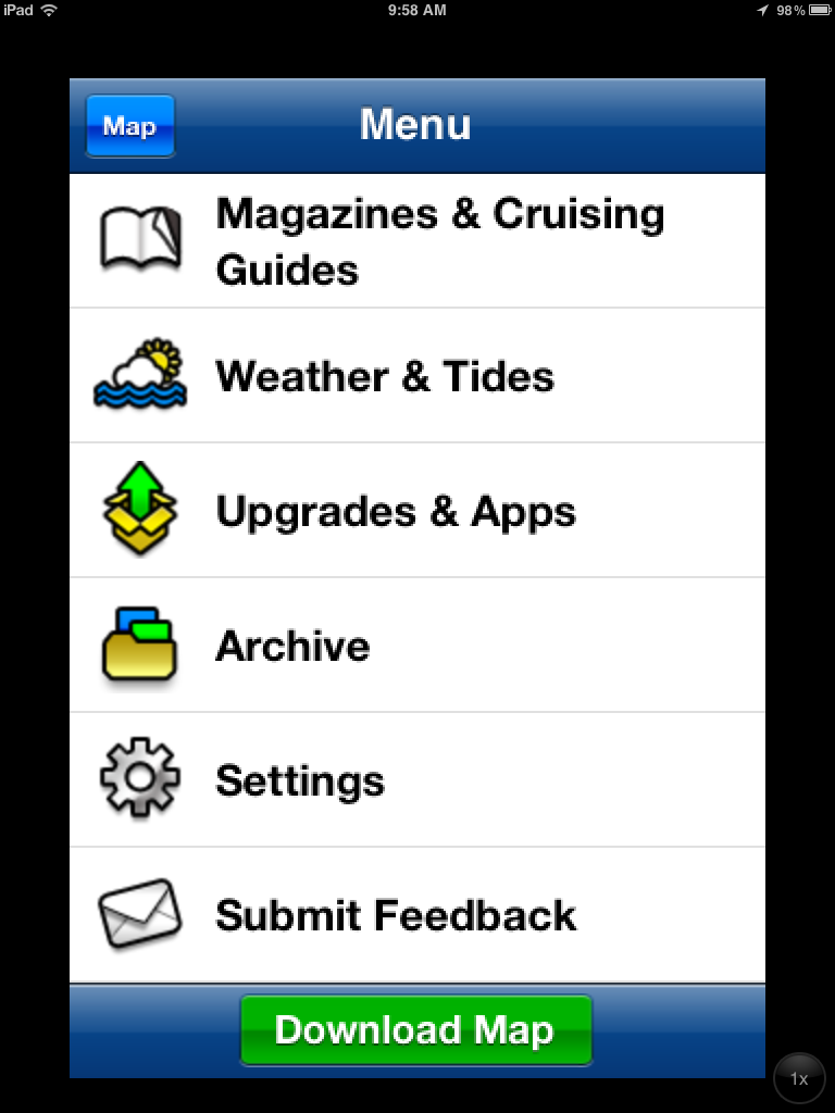
When you first open up the app you are presented with a main menu.  This menu has several selections including Add Point, Sync Waypoints, Picture, Settings, Waypoints, Profile, Anchor Alert, Group and Morse.

The menu icons are very nicely done and someone evidently put alot of work into developing them. Great job Marco!

It was not immediately evident how to get to the charts. You have to first go to the Waypoints section and select map in the upper right hand corner

I would like to suggest the addition of some soft keys at the bottom of the screen to access the Map, Charts and other features of the app directly. 


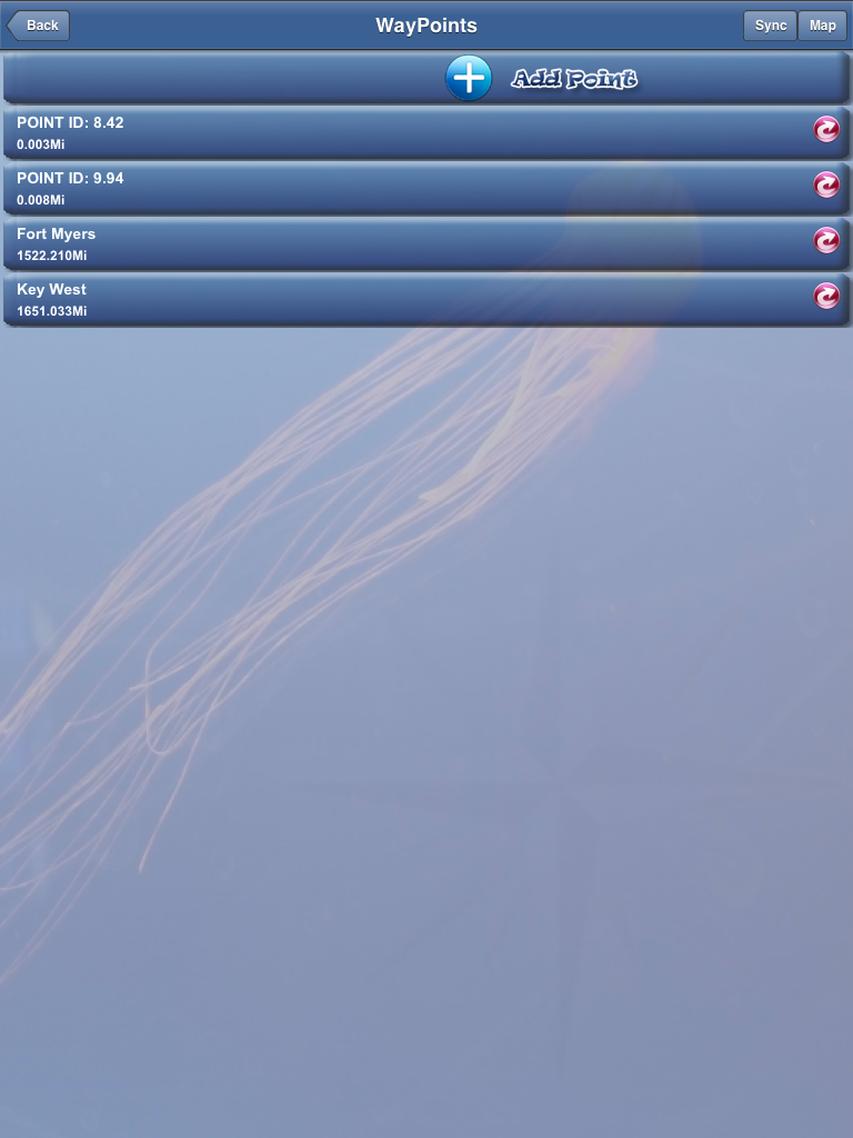
Waypoints are the essential building blocks of marine navigation. The app allows the user to add and manage waypoints easily. You can add waypoints using the the + Add Waypoints icon in the upper left side of the main menu.  You can select the WayPoints icon in the upper right side of the main menu to add them also.  I am not sure why there are two ways to do this. I think they could be combined into one icon to add and manage waypoints.

The app has the ability to back up or synch your waypoints. You will first have to set up an account with FishPoints on the Profile page and then select the Synch button in the top right of the Waypoints display. There is also an icon on the main menu to Sync WayPoints

Select a waypoint from this menu by tapping one of the listed waypoints. This allows the user to Navigate, Update or Delete the waypoint.

The Navigate screen shows your existing position as a green dot and your destination Waypoint as a red dot. It would be nice to have a line from the start to the destination waypoint to aid in navigating.

The bottom of the display shows some basic navigation information. The current direction, direction to the waypoint, speed and distance to the waypoint information is shown.  If I was using this on my boat to navigate I would want the text of the information much larger and bold so I could see it from a distance.  There appears to be plenty of room at the bottom to accommodate larger text for the instrument data. Use standard marine instrument terms like SOG(speed over ground) COG(course over ground), HDG(heading), BTW(bearing to waypoint) and DTW(distance to waypoint).

A nice additional feature would be to display which waypoint I was navigating to. It did not appear to have the ability to navigate to the next waypoint in the list or multiple waypoints. Another nice addition would be to have the ability to create a route with multiple waypoints and navigate along that route.
                                                      
The Maps or Charts page appears when you select the Map icon in the top right of the Waypoints screen.  The chart will come up showing your current GPS location. You will have to pan around to view other locations.

The basic iPad navigation features of pan, zoom and pinch seem to work but at times the charts updated very slowly.  The author should look into improving the speed and rendering of the charts.

The charts are quilted so when you pan around the proper charts are displayed for your viewing area. The Maps selection at the top right of the screen allows you to select Marine Map, Base Map and NOAA charts.  The NOAA charts are displayed in the image at left and note the waypoints I added for Fort Myers and Key West.

Just to the left of the Map selection icon is a Tools icon. Select the Tools icon to allow the addition of Waypoints directly on the chart by tapping your finger on a location. If the location is not quite correct re-tap your finger to get it right where you want it. Then select Create the POI.

Here I have added a point near a lighted tower.  I then selected Create POI at the bottom of the screen to create the new Waypoint.  I am not sure why the author calls it a POI.  The new waypoint also shows up in the Waypoints list. Points of interest are often, marinas, resorts, restuarants or stores.

I also like the functionality of the slide bar in the upper left of the screen for adjusting the zoom level of the display.  At times there was a long delay in the repainting of the chart display.

Back on the main menu you can select the Picture icon to add and share photos of your boating and sailing adventures. Select the upload icon in the top right of the screen to select a photo from your camera roll or take a picture with your iPhone or iPad camera.  Select Load Image to upload the photo.

The Settings Icon let you select measurement units, set up Tracking points and save maps and charts for offline use.  A GPS info icon in the upper right of this screen will show your GPS data. It appears that the data for altitude and accuracy are in meters.

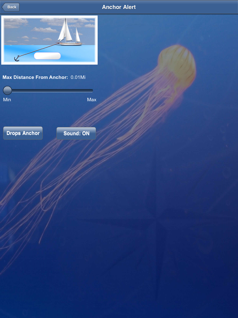
The Anchor Alert icon will bring up a basic anchor alarm function. Simply set the distance from your anchor. If the distance increases from this setting an alarm will sound alerting you that you are dragging from your anchored position.  It would be nice to set the distance in feet or meters rather than miles.

The Group Icon allows you to create groups within the app.  Your friends can then join your group and see information, pictures and location information that you share.

The Morse Icon takes you to the Morse code page where you can type in a message and have it played back in Morse code.  Not sure when I would ever need this feature, but it is a cool feature.

The bottom line, the app will allow you to do some basic navigation on the NOAA raster charts. I liked being able to create groups and share photos with others in my group. The artwork in the app is also very nicely done.  With a few additions and performance improvements it could become an even more useful app for boaters. 

~~~Sai On~~~ /)
Mark

Monday, September 3, 2012

Organize Your iPad Apps

I have been writing about iPhone and iPad apps for about a year and a half now.  It has been a great learning experience for me and I hope that I have helped a few of you understand these apps a little better too. Hey, that's the whole idea behind this blog.

I thought it would be fun to share with you some of the apps that I have on my iPad and iPhone. Please give me some feedback on what some of your favorite apps are also. I am always looking for great apps to review!

I have my iPad organized into folders. As you all know, to create a folder simply hold your finger on any app until all your apps start jiggling. You can then drag one app over another to create a folder. The folder can then be renamed to describe what kind of apps are in the folder.  This also eliminates having to search through many pages of apps to find the right one.  I like folders because it allows me to neatly organize all  my apps by their function. Who doesn't like organization?

My wife thinks I am a little anal for such organization.  Ok, I admit I am very anal! But I find that it makes it easier to find my apps and it seems to work for me.  If you have a better way or organizing your apps please let me know.

The Camera/Video folder contains the Camera app which is the stock Apple camera app for taking pictures or video.  Facetime is a cool tool to video conference with someone anywhere in the world. I recently use Facetime to talk to my brother while he was on vacation in St. Lucia.  iMovie lets you quickly put together a polished video of your latest vaction footage. 360 Panorama allows you to create a super wide angle shot. The stock Apple Video player app allows you to watch any purchased iTunes videos.  The Adobe Photo Shop Express app is handy for doing some basic editing of your photos.

Games, I am not a big game player but I do on occasion finding myself so bored that I might play Angry Bird, Solitaire or some Black Jack.  Games are a great way to pass time. If you have kids your Games folder will likely be full of fun and educational games to entertain them.

GPS apps abound in the iTunes Store.  A few that I like are MotionX-GPS, Google Maps and CoPilot. CoPilot is a great turn by turn app used for street navigation. When I am not on the water I use CoPilot to find hotels, restaurants and other points of interest.  The Google Earth apps is amazing for exploring anywhere in the world!

The Media folder contains, YouTube, TV.Com, ABC, TNT, NBC, Facebook, Linkedin, Messages, iTunes, App Store and the Chrome browser.  These allow me to catch up on some of my favorite network shows.

The Remote app is handy for controlling my Apple TV or iTunes on my laptop. Netflix gives you access to thousands of movies and TV shows for a monthly fee.  Pandora, another favorite of mine, connects to Internet radio.  Internet base programming is plentiful and easily accessed with these apps with a cell or WiFi connection.

My Marine Nav folder contains mainly GPS charting apps. I have some favorites but I find that one app does not fulfill all my needs. Reviewing all of these apps lets me have the opportunity to try them all. My favorites are iNavX, iSailor, Navionics USA, EarthNC, iRegatta, Plan2Nav, SEAiq, Marine Navigator and FlytoMaps All in One.

iNavX is my go to app for now but there are others that are very capable. Navionics would be next on my list and SEAiq is rapidly developing many new features that make it a real contender.  Garmin was suppose to release their marine charting app this summer but I have not seen it yet.  Check out all of these on my list of Best Marine Charting Apps.

The Marine folder has a variety of apps related to the marine industry. Tides, NavLights, NMEA Remote, CompassHD, Sailmaster, MID WiFi, DragQueen, Compass Eye, Sea Tow, Boat HUD, Nav Rules, Harry's Sailor and MarinaLife.  If you need information, rules, regulations, NMEA data, marine points of interest or emergency help, there is an app in this section to assist you.

To display your ships NMEA data MID WiFi is my favorite. This can use the devices GPS locational data or it can be set up to remotely receive your ships data from an onboard WiFi server. DragQueen is a very functional anchor alarm provided for free from the folks at Active Captain, thank you. Everyone should have a copy of the Nav Rules onboard.  MarinaLife is a nice database of marine services.

My Productivity folder contains apps that help me do business while on the road. Notes, Calendar, Contacts, Pages, Calculator, Google, CloudOn, DropBox, Onlive Desktop and Reminders are all valuable apps for getting stuff done.

Pages is a great word processor for recording your ships log information or just writing your thoughts down. The files can be saved and exported or emailed as a Pages, PDF or Microsoft Word file.  Onlive Desktop provides you a complete Windows Desktop accessed through your iPhone or iPad. This is handy to work on your Word, Powerpoint or Excel documents and save or export them.  CloudOn works with Dropbox to give you editing capability for Word and Excel documents also. 

The Travel folder has Kayak, Fly Delta, Yahoo Markets, American Airlines,Translate and Trip Advisor. Kayak is a super app for checking airline flights, car and hotel rentals across many different travel sites. If you travel internationally you can speak or type any word into Google Translate and have it translate it into
numerous other languages.  Trip Advisor is my favorite for getting honest reviews of destinations, hotels, restaurants and more.  Don't get stuck in a crummy hotel, check Trip Advisor to make sure the place you booked is going to meet your needs.

My Utilities folder contains Find My iPhone, Slashtop Desktop, iHandy Level, Flashlight, Convert, Alarm Clock and Splashtop CamFind my iPhone is a must for me. It is great for finding my own phone, plus it gives me the ability to check in on my wife and kids locations anywhere in the world.  Splashtop Desktop it a great tool which allows you to view and control programs on your laptop or PC remotely.  You can use your iPhone or the iPad to view and control the marine charting programs running on your laptop. No need to buy expensive multifunction displays.  The Splashtop Cam app gives you access and control of your webcam on your laptop or PC remotely over the Internet.  Use this to remotely monitor your boat or home from any iPhone or iPad. The Flashlight app uses the LED on your iPhone to provide a bright light source for those emergency needs. The Convert Units app is handy for converting temperature, measurements, currency, pressure, speed, length and other units.

Weather apps include, Weather Channel, KeloLand Local weather, Wind Meter, MyRadar, Intellicast HD, Planets, WunderMap, Weather4D and Intellicast Boating.  Most smart boaters pay attention to the weather and forecasts.  This list of weather apps should provide all the weather information you will ever need.  Weather4D allows you to download GRIB files and display time lapse forecast data on your iPad.  Intellicast Boating is the first weather app to incorporate NOAA raster charts into their extensive list of forecasts and real time data. Stay aware of the weather and keep your crew safe.

AIS apps include mAIS, Boat Beacon, Shipfinder, and SFHD Free.  AIS stands for Automatic Identification System. Large commercial ships are required to broadcast this data for safety purposes.   Many land based receivers are being set up to make this position data available to anyone on the Internet.  These apps accesses this data through the Internet and give boaters situational awareness of ship in their area.

On the bottom of my screen I have the standard apps for the Safari Browser, Mail, Music, Photos, Newstand and Settings. NewStand is great for keeping track of all your sailing or boating magazines.

There you have it! These are a few of my favorite apps.  Let me know what apps you are using on your devices. Please give me some feedback!