 Application: iPhone, iPad, iPod Touch
Function: Mobile Marine Navigation and Charting app
Rating:*****
Price: App is free, $14.99 US version
 There are no shortage of marine charting apps out on the market. I have reviewed many over the years and I can tell within a few minute of using them if they are worthy of making my Top 10 List. GPS Nautical i-Boating is a solid marine charting app using NOAA vector charts and USACE inland rivers. It has many of the basics features needed to be a decent app including Waypoints, Routes, Tracks, GPS Tracking, Tides, Currents and sharing of routes, tracks and markers. Although this is a nice list of features there are many competing apps with similar features.
One unique thing about GPS Nautical i- Boating is that it is available on many platforms. Versions are available for the iPhone or iPad, Android phone or tablet, Windows 8 phone, laptop or tablet, and Blackberry phone or tablet. I know of no other marine app that is available over so many platforms. You should be able to find a version that works on your phone, tablet or laptop.
It is getting harder for may apps to compete with the "Big Boys" like Garmin and Navionics who provide free apps with many built in features. These apps also require in app purchases for charts and additional features.
Features:
- GPU accelerated vector charts
- Query the details of Marine object Buoy, Lights, Obstruction.
- Customizable depth(Ft/Fathom/Meter) and distance units (km/mi/NM)
- Customizable Shallow Depth.
- Record tracks, Autofollow with real-time track overlay and predicted path vector
- Voice Prompts for marine navigation (requires GPS
- 1ft / 3ft depth contour maps for anglers for selected lake maps.
- Supports GPX/KML for boating route editing/import
- Tide & Currents prediction
- Seamless chart quilting of marine charts
- Enter or import Waypoints
- NOAA vector charts, USACE inland rivers and lakes
- Create New Route/Edit Existing Routes
- Move Points
- Add points to an existing route leg
- Delete / Rename points
- Import GPX, KML & KMZ files
- Plot/Edit Routes
- Enter Waypoints
- Share/Export Routes, Tracks & Markers
- Reverse Routes
- GPS Auto Follow
- Real Time Track Overlay
- Predicted Path Vector
- Course Up (Text stays upright)
- Speed & Heading
- Route Assistance With Voice Prompts
- Prompts when approaching a boating route marker
- Continous distance and ETA updates
- Alerts when sailing/boating off route
- Alerts when boating in wrong direction
- Record Tracks
- Tide and Currents for US, Canada, UK, Germany & New Zealand
- High/Low Tides
- Tidal Current Prediction
- Active Current Stations
- Share tracks/routes/markers on Facebook & Twitter
- Export tracks/routes/markers as compressed GPX files.
- United States of America- derived from NOAA and USACE data
- Central & Pacific Canada Charts - derived from CHS data
- Marine Navigation - United Kingdom / Ireland - derived from UKHO data
- Netherlands Nautical Charts - derived from NLHO data
- Belgium Nautical Charts - derived from VH data
- Iceland Nautical Charts - derived from ICG-HD data
- Germany Nautical Charts -derived from BSH data
- Caribbean Nautical Charts - derived from UKHO & NLHO data
- South Africa Nautical Charts - derived from SANHO & UKHO data
- Croatia Nautical Charts
- Oman Nautical Charts
- Estonia Nautical Charts
- Malta
- Argentina
- Portugal
- Spain
- Brazil
- Austria
- Denmark
- Latvia
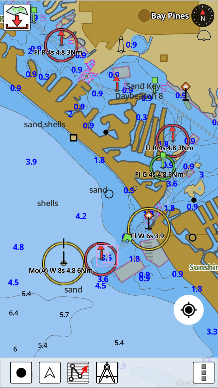
 The app has a main navigation screen with several icons to help with setup and viewing of your position or course. The free app does not come with any charts. You will have to purchase charts for your regions. These range form $14.99 to 25.99 depending which area you need.
 Once you have purchased charts you will be able to download the portion of the chart you need for navigation. In the upper left of the screen is the Chart Download icon. Tap this and you will be shown a tiled map overlay of the charts to download.
The green colored tiles show the ones I had previously downloaded. I tapped the tile to the right and it turned purple. Simply press the Press to Download bar on the top to download your chart tiles to your device. More than one tile can be selected and downloaded at a time. The charts can then be used offline while out cell range.
Other icons are displayed across the bottom of the screen. On the bottom left of the screen is the Record Track, Follow, Route, Measuring Tool and Menu icons. The Tracking feature is nice to have to see where you have travelled. Tracks are automatically saved and can be found under the Route icon.
The Follow feature icon is second from the left and is used to engage the follow mode. In follow mode the app will keep your position centered on the chart as you move. Additional details including speed and course are shown in the lower left of the screen.
 The next icon is the Route Manager which allows the creation of new routes and viewing of saved routes, waypoints and recorded tracks. Importing of GPX and KML route files can also be done through this display.
Routes and Waypoints can also be renamed, deleted or edited from the Route Manger.
Select Create New Route to enter route creation mode. Several icons in the route manager are displayed across the top of the screen. The Hand icon allow you to pan around the display, the Pin icon allows placing a marker for a favorite fishing spot or a hazard.
The Route icon is selected to create a new route. Simply set the cross hairs to the location to make your first waypoint and tap the New Point box, pan to the next location and tap it again. Continue tapping to create all your waypoints within a route. Next select the Save Icon to name and save your route for retrieval later.
As you create a route your can delete the last point if you make a mistake. Select the grey box "Delete Last".
It would be handier to have a Waypoint icon on the bottom menu to easily create and edit waypoints like the Route icon. To create or view waypoints the Menu icon has to be first selected. Under the New Waypoints selection you can use the current GPS location, enter the latitude and longitude or use the cursor crosshairs to make a waypoint. One unique feature is being able to Geo tag a photo at a waypoint.

The Tides and Currents selection allows making favorites of your tide and current stations. The data is listed in tabular form. Once you save a favorite they all go into one list. It would be nice to have separate favorites lists or a way to differentiate so you can identify which ones are tidal and which one are for currents.
Voice prompts can be enabled within the Menu/Settings selections. Voice prompts can be set up to notify that you have reached a marker or waypoint. Notifications for ETA and distance are continuously updated. It will even alert you when you are off course or going the wrong direction.
GPS Nautical has done a great job with the basics and I am impressed with the presentation of the NOAA ENC vector charts. They are very bright and easy to read and contain many useful navigational aids.
Some features that I would like to see are some points of interest. Active Captain is used by many app developers and it is provided to them for free. Very basic instrument data is displayed. Incorporation of NMEA 0183 instrument data over WiFi would be a nice feature also. With WiFi you could also add AIS to display nearby ships for collision avoidance. Some form of weather and display options for satellite maps would be a bonus also.
If your looking for a solid entry level app with great charts i-Boating just may be for you. Check it out in the app store and let me know what you think!
~~~ Sail On ~~~ /)
Mark
Do you know if i-Boating apps for navigation can be used on an iPad without cellular service?
ReplyDeleteGerald,
DeleteIf your iPad does not have the cellular service it will not have any GPS locational service features while away from land. The iPads with cellular service have assisted GPS which will give you your GPS position while away from WiFi and cellular service. The non cellular iPads will not.
It is worth the extra $100 to buy an iPad with the service even if you don't activate it, the GPS features will still be available.
There are many Bluetooth GPS devices that you can connect to your iPad to give is GPS capability. Check these out here.
http://i-marineapps.blogspot.com/p/gps-for-iphone-ipad.html
Become a follower and click on a few Google adds to help me pay the bills.
Good luck
Mark
This comment has been removed by a blog administrator.
ReplyDeleteThis comment has been removed by a blog administrator.
ReplyDeleteThis app is not good enough for boating and no proper support from the company
ReplyDeleteMus,
DeleteThanks for your comment! This app is not one of my favorites either and I do not use it. I try to review all the charting app options out there and list all the features to allow the users to make their own decisions. I have of list of my top Charting apps on a tab at the top of my blog. Check these out for the most used and supported apps.
Stop back soon and click the Follow button on the right column to follow the blog.
Happy New Year!
Mark
Checked your reviews but am not sure which app you would recommend...was hard to understand exactly what you were trying to convey with your reviews so that's why I'm replying to your post...thanks.
DeleteGreg, The easiest and best marine charting app to use is Navionics Boating. Download the app for free for a 15 day free trial. Then download the maps for your region $9.99 for the USA. It provides great charts, tracking, weather, tides, currents, markers and routing. It would be a great app for about any type of boating.
DeleteGood luck!
Mark
Never realised there are so many good apps. Great article, thanks.
ReplyDeleteWhere can I find the distance to waypoints?
ReplyDeleteThis comment has been removed by a blog administrator.
ReplyDeletePretty good post. I just stumbled upon your blog and wanted to say that I have really enjoyed reading your blog posts. Any way I'll be subscribing to your feed and I hope you post again soon. Big thanks for the useful info.
ReplyDeleteHey, this is very nice post. I love this post. But if you are looking for 4G OBD GPS tracker for your automobile VT400 4G OBD tracker from ThinkRace is the newest design OBD II GPS tracker for car. Having high accuracy in location, history playback, Geo-fencing, the ThinkRace Technology OBD tracker factory help you enjoy a smart fleet management. With easy installation, tracking device is ideal for Automobile Industries, Logistic Companies, and Insurance Companies.
ReplyDelete
ReplyDeleteThanks for sharing such kind of nice and wonderful collection......Nice post keep it up and keep sharing. Do you want boat accessories? Visit here Spring Hook
nice
ReplyDeleteI loved your article!! It has given me plenty to think about moving forward on my social media journey!
ReplyDeletePUBG PC Crack
This comment has been removed by a blog administrator.
ReplyDeleteI have been running I-Boating on Android for nearly a year. Everything was good. Recently bought the iPhone 12. Position seems accurate but speed reads zero more than not when sailing. Any ideas what could be going on? Location sharing to app was on. Even rebooted just to be sure.
ReplyDeleteI really liked your Information. Keep up the good work. Best Boating App
ReplyDeleteThis comment has been removed by a blog administrator.
ReplyDeletefield force automation app
ReplyDeletefield force tracking app
field staff tracking app
ReplyDeleteSharetipsinfo is investment and trading solutions company is leading Share Market Tips company. Sharetipsinfo provides all types of online stock trading includes best investment tips to their customers. Sharetipsinfo share trading have best Stock Market Tips for investors, equity shares, stock shares and many types of investments in share markets.
Looking for simple instructions instead of a review of every feature.
ReplyDeleteThis comment has been removed by a blog administrator.
ReplyDeleteI think this is a better than average article. You make this data intriguing and locks in.
ReplyDeleteSo we are also providing the printer http //ij.start.canon setup repairing service online. You can repair your printer remotely. If you have any query so visit our website - canon.cpm/ijsetup
This comment has been removed by a blog administrator.
ReplyDeleteThis comment has been removed by a blog administrator.
ReplyDeleteThis comment has been removed by a blog administrator.
ReplyDeleteİsmetpaşa
ReplyDeleteKnidos
Sanayi
İhsaniye
Bostanlı
JUS
Are you plannin강릉출장샵g on hosting a swap anytime soon? I recently stumbled upon busy bags and think my little man would devour them!
ReplyDeletedenizli evden eve nakliyat
ReplyDeletekars evden eve nakliyat
çorum evden eve nakliyat
kars evden eve nakliyat
malatya evden eve nakliyat
JN3CZ
8E519
ReplyDeleteIğdır Parça Eşya Taşıma
Batman Şehir İçi Nakliyat
Mersin Parça Eşya Taşıma
Eskişehir Şehirler Arası Nakliyat
Ordu Evden Eve Nakliyat
Etlik Boya Ustası
Coin Nedir
Bitfinex Güvenilir mi
Kastamonu Şehir İçi Nakliyat
DF562
ReplyDeleteCoin Madenciliği Siteleri
Kripto Para Nasıl Alınır
Kripto Para Kazanma
Coin Çıkarma
Coin Oynama
Coin Madenciliği Nedir
Binance Madenciliği Nedir
Coin Nasıl Çıkarılır
Yeni Çıkacak Coin Nasıl Alınır
55A82
ReplyDeletesamsun ücretsiz görüntülü sohbet
Şırnak Kızlarla Canlı Sohbet
yabancı görüntülü sohbet siteleri
en iyi ücretsiz sohbet uygulamaları
kocaeli kadınlarla ücretsiz sohbet
yalova muhabbet sohbet
rastgele görüntülü sohbet ücretsiz
ığdır nanytoo sohbet
siirt sesli sohbet uygulamaları
360CE
ReplyDeleteBinance Referans Kodu
Bitcoin Çıkarma Siteleri
Binance Yaş Sınırı
Linkedin Beğeni Hilesi
Bitcoin Nedir
Threads Takipçi Hilesi
Kripto Para Nasıl Alınır
Star Atlas Coin Hangi Borsada
Binance Nasıl Üye Olunur
B27F4
ReplyDeleteraydium
poocoin
galagames
arculus
dexscreener
poocoin
onekey
phantom
poocoin
regytryhtrtretgryhrtyh
ReplyDeleteشركة مكافحة الحمام بالاحساء
شركة مكافحة الصراصير بالاحساء IYm6hZhcch
ReplyDeleteHistoric nautical charts are invaluable artifacts that reveal how sailors once navigated the seas. They showcase early mapping techniques, trade routes, and coastal discoveries, blending art with science. These charts not only guided explorers but also preserve maritime heritage, offering insights into exploration, commerce, and cultural exchange.
ReplyDelete