Monday, December 19, 2011

DMK Yacht Instruments


Application: iPhone, iPad, iPod Touch
Function: Marine data and instrument display
Rating: ****
Cost: App is free, black box is $399.00 or with GPS 499.00

There are many communication protocols out there when it comes to marine instruments.  Many of us have the older NMEA 0183, while others may have upgraded to NMEA 2000.  If you have Raymarine on board you are dealing with SeaTalk. Some may have all three onboard.  The problem has always been how do we tie all of these together to make them available to our laptops, iPhones and iPads.  DMK has built a system to address this very problem.

DMK Yacht Instruments has put together a versatile data display app for your iPad, iPhone or iPod touch.  The app uses the UDP protocol over WiFi to retreive the data from the DMK proprietary black box that must be purchased separately.
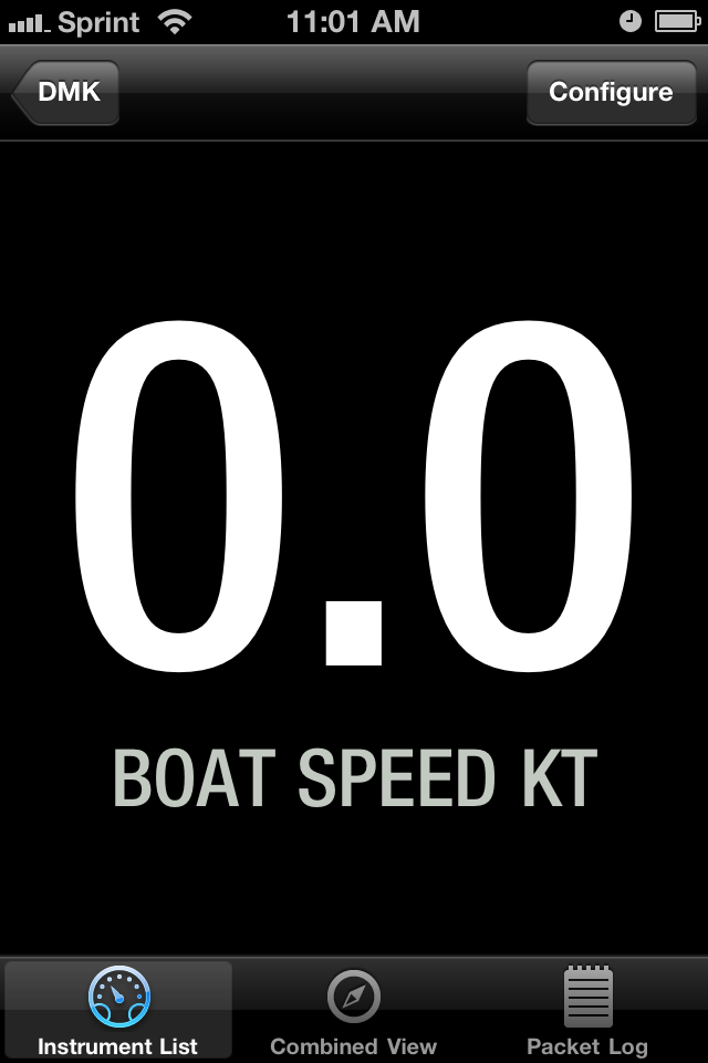

iPhone view
App features include:
  • iOS 4.2+
  • iPad, iPhone, iPod Touch
  • Apparent Wind Speed
  • Apparent Wind Angle
  • Boat Speed
  • Depth Below Transducer
Black Box features include:
  • Accepts any combination of Raymarine SeaTalk®, NMEA 0183, and NMEA 2000 inputs
  • Uses WiFi to send the sentences for each protocol as UDP packet payload
  • Two NMEA 0183 connections
    Separately configurable baud rates: 4800, 9600, 19200, 38400, 57600, 114200
Main Instrument View

  • One Raymarine SeaTalk® connection
  • One NMEA 2000 connection
Includes an RP-SMA Wi-Fi rubber duck antenna
  • FCC-approved Wi-Fi transmitter
  • Requires external power DC: 5-12v
Model 11A-GPS Only
  • Built-in 14-channel GPS
  • Includes an external passive GPS antenna which connects via threaded SMA socket
  • 0183 GPS Out; use this to provide location data to e.g. a Standard Horizon AIS radio


There are options to display the instrument by itself and change the options of the display. You can select digital or analog mode, fathoms, feet for meters for depth and options for Celsius of Fahrenheit for temperature.

 
These two screens allow you to manage logging and settings for the wireless network within the app.

I like that is has the flexibility to accept NMEA 0183, NMEA 2000 and SeaTalk protocols simultaneously.  This give you options if you have a mixture of different instrument types on your boat.  NMEA 2000 is the newest technology but there are still many of NMEA 0183 systems out there. If your a Raymarine fan SeaTalk is the protocol they use.

I don't like that the app only displays four instrument types.  Their webpage says that this is only a demonstration app. I assume DMK provides additional NMEA sentence support for other instruments.  DMK is selling the WiFi hardware for $399, or $499 if you want the GPS option.  iNavX is another app that can accept and display the data from the DMK box.  DMK uses port 1703 and UDP protocol. See the iNavX setup instructions here.  I assume other apps could be designed to access the data wirelessly through DMK's black box. Some apps allow the user to also use the iPhone or iPad's internal GPS for speed and location data. DMK's apps does not allow this.

There are cheaper options out there to connect your varied NMEA protocols to your iPad. Using the Actisense products to connect your NMEA 2000 or 0183 instruments to your laptop would be less expensive.  The laptop could then relay data via TCP/IP to an iPad app like iNavX or Mid +WiFi.

The Brookhouse iMux will connect your iPad or iPhone through WiFi to your NMEA 0183 and SeaTalk instruments.  There are lots of options our there. DMK has built a device to handle all the possible protocol options. Research which one fits your situation best and go with that. Hope this was helpful. What is everyone else using as a display app? Appreciate any feedback.


Sunday, December 4, 2011

Volvo Ocean Race - Leg 1 Recap

Telefonica wins first leg! Three of the six boats in this years Volvo Ocean Race have finished leg 1 in Cape Town, South Africa after 7480 miles of racing.  The other three boats suffered equipment failures and had to drop out of the first leg.  Sanya had problems with their hull separating and Puma and Abu Dhabi both lost their masts while racing.

Sanya and Abu Dhabi were shipped to Cape Town where repairs are underway. All boats plan to take part in the next leg of the race. Puma motored to the small island of Tristan da Cunha and has since been picked up by a freighter and is en route to Cape Town also.

In case you missed all the action you can see a great video highlighting the first leg of the race. See it here. http://www.youtube.com/watch?v=WqOsqvKARww&feature=player_embedded

Next on the schedule is an in port race on Saturday December 10th. Leg 2 of the race from Cape Town to Abu Dhabi is 6249 miles and will starts December 11th.

Follow all the action on the Volvo Ocean Race website.

Saturday, December 3, 2011

Tidal Chronoscope

Application: iPhone, iPad and iPod Touch
Function: Solar, Lunar and Tidal Info
Rating: ***
Cost: $2.99


Growing up in South Dakota and sailing on inland lakes I did not have to worry much about tides.  Tides as we all know are the daily rise and fall of the worlds oceans which are influenced by the gravitational pull of the sun and moon.  Many locations usually experience two high tides and two low tides each day.  Some places experience only one high and one low tide each day. Tides can range as high as 55 feet in the Bay of Fundy to a few inches in the Mediterranean and Caribbean. These extreme high tides occurs around the time of the full or new moon when the gravitational forces of both the Sun and Moon are in phase reinforcing each other.

Since I have been sailing on the oceans and coastal areas I have learned to pay attention to the daily tides. Coastal cruising in Florida has been especially interesting at times.  I was contacted by ChronGlobal and asked if I would take a look at their app and give my impressions about their Tidal Chronoscope app.

The Chronoscope comes is both an iOS and Android version so we all can enjoy this app. The app attempts to provide data in three different areas that are easily selected with the soft keys at the bottom of the app. Tidal, Solar and Lunar data are depicted on a watch or chronograph face. The whole idea of the watch faces seems confusing at first but after working with it for a while it grows on you. Some users have commented that it is hard to use and figure out. We all use a watch to tell time why not use it to show astronomical data.

Tidal Features:
  • Dedicated watch face for graphic and relative depiction of current state of the tides at current or any give time up to 7 days.
  • GPS location based for instant and current tide information for local or optional locations
  • Choice of over 9400 tide stations world wide
  • Tide watch shows how many hours to high and low tide
  • Information screen for detailed tide event
  • Tidal indicator depicts current moon phase for predicting neap and spring tides
  • Option setting of watch for up to 7 day predictions for hourly/minute future tide predication simply by setting the watch to desired date and time.
  • Option predicting future current tide time by the hour
  • Choose between meters and feet for tidal depth
  • Option for updating time and distance interval
  • A turn of the watch crown for minute and hour increments provides future tidal data.
  • A tap on the date provides a date and hour wheel for future time setting or manual adjustment
  • Save your favorite port.
  • Option to follow the tides of another location using your current time zone.
Lunar Features:
  • Dedicated watch face for a graphic depiction of current moon phase and relative position of the moon in the sky.
  • GPS location based
  • Indicates position of the moon in the visible sky
  • Striped moon indicates where moon is in non visible sky
  • Depicts moon phase and all progressive phases
  • Depicts moon rise and moon set
  • Depicts the moon as it transits the visible and non visible sky
  • Predict moon position and phase up to 7 days by the hour or day by simply setting the watch to desired date and time
  • ‘Moon over’ and ‘Moon under’ depiction
  • A turn of the watch crown for minute and hour increments provides future moon data
  • A tap on the date provides a date and hour wheel for future time setting or manual adjustment
Solar Features:
  • Dedicated watch face for a graphic depiction of the current and relative position of the sun in the visible and non visible sky
  • GPS location based
  • Indicates relative position of the Sun in your location
  • Yellow sun indicates in visible sky
  • Blanked out sun indicates moon in non visible sky
  • Sunrise and sunset depiction
  • 7 day prediction up to 7 days by the hour or day by simply resetting the watch
  • A turn of the watch crown for minute and hour increments provides future sun data
  • A tap on the date provides a date and hour wheel for future time setting or manual adjustment
The app is very versatile and allows you to customize the look of your chronograph with several different styles and colors. If your looking for a unique and fun way of looking at Tide, Solar an Lunar data, check out ChronGlobal's Chronoscope app.

Friday, November 25, 2011

AIS Radar

Application: iPhone, iPad
Function: AIS charting and information
Rating: **
Cost: $11.99


AIS can be used by the long distance cruiser or the weekend coastal boater to add a level of safety. AIS Radar is a reasonably priced app that will give you some basic AIS functionality.


AIS stands for Automatic Identification System.  Large international commercial ships and all passenger ships are required by law to broadcast AIS data to prevent collision and increase safety while at sea.  It is estimated that there are about 40,000 ships currently carry AIS class A equipment. The new Class B AIS standard was introduced in 2007 and created a new generation of low cost AIS transceivers.  AIS will not replace conventional radar but can be used to assist the yachtsman in collision avoidance.

AIS is becoming more popular with the advent of cheaper software and hardware. AIS uses VHF frequencies to broadcast and receive the AIS data and targets. AIS Radar can display data received from marine AIS transponders such as the ExNC 101 Class B AIS Transponder over a WiFi network. For AIS transponders or receivers without built-in WiFi support, an external serial WiFi adapter such as the SEAMate1A Lite, the Brookhouse iMux, the Roving Networks RN-370 or the Digi Connect® Wi-SP can be used.

Data from public AIS networks can optionally be displayed from the Internet.

Features:
  • Radar like display of AIS data and targets.
  • Course, heading and speed information of targets
  • Variable radar display range
  • Multiple symbols for AIS targets. Class A and class B transponders.
  • Computes CPA, closest point of approach and TCPA, time to closest point of approach.
  • Multitouch gestures to select display range
  • Display modes of heading up, course up and north up
  • Options to hide slow moving targets from radar display
  • List of AIS targets and display all information about the targets
  • Viewer for AIS safely related broadcast messages
Four soft keys, Radar, Targets, Messages and Settings are used to navigate within the app. The radar like display shows real time AIS targets. Targets are shown with different symbols depending on if they are AIS A or B. The app allows different radar ranges to be selected with multi touch gestures.

The Targets display gives you a list of AIS targets which can be selected to give more details. The name, call sign, type, status, speed, course and heading can all be viewed.

The price of app at $11.99 is reasonable if your just looking for a stand alone AIS app. The one draw back is that it does not display the targets on a marine chart. There are several charting apps that do also include AIS displays.  If you have the iNavx app the AIS display is integrated into the charting display.  I have a list of the Top 5 Best AIS apps listed on my blog. Check them all out and see which one fits your needs.

Saturday, November 19, 2011

Digital Yacht - iOnboard

Application: iPhone, iPad, iPod touch
Function: Marine data display
Rating: ***
Cost: $6.99

Digital Yacht has had quite a year with an introduction of many new electronics for the yachting enthusiast. They were just recently awarded the DAME 2011 NMEA award for marine electronics. The company creates devices that take your onboard navigation, instrumentation and AIS data and through WiFi makes this data available to mobile devices. The Digital Yacht WLN10 NMEA to wireless server the BOATraNet and iAIS systems provide these wireless data networks.

The iOnboard app is used on your iPhone or iPad to display the data from the wireless network. GPS data, instrumentation, navigation and AIS data are easily viewed when and where you want.  The iPad or iPhone are more mobile and less expensive than a full blown stand alone multifunction display.  Through a wireless TCP/IP link the data is transferred from the onboard server to your mobile device.

The app has four soft keys across the bottom. These access the GPS, navigation, instruments and settings pages.  The GPS page list the typical GPS coordinates, speed and course over ground, date and time. Additional pages show the list of GPS satellites and locations.


The navigation pages show course, heading and track displays to keep you on course. The instrument pages provide gauge like dials showing additional navigation instrument.

Digital Yacht also has another free app called Digital AIS.  This app displays AIS data on your mobile device from an onboard wireless AIS network.

The Automatic Identification System (AIS) is an automated tracking system used on ships and by Vessel Tracking Services for identifying and locating ships by electronically exchanging data with other nearby ships and VTS stations.

The Digital AIS app has a radar like display showing ships in your area and provides important information about the ships name, speed, course, heading and length.  AIS is valuable tool to keep track of possible collision courses with surrounding ship traffic. 

Both of these apps require that that you have onboard instrumentation networks and a WiFi network setup to broadcast the NMEA data. If all of your ships data is connected to your laptop you can set up an adhoc network to send this data to your mobile devices.  Digital Yacht has several WiFi devices that can be setup to create a WiFi network on your boat also.  There are many data display apps out there. The iOnboard app provides similar data to the NMEA Remote and MID+WiFi apps that I have reviewed. At $6.99 for the iPad version this is cheaper than the other two.  Take a good look at them all to see what fits your needs the best.

Thursday, November 17, 2011

Caribbean 1500

As fall approaches, sailors start thinking about the sunny skies and balmy trade winds of the Caribbean. This year 62 boats are heading south as part of the 22nd annual Caribbean 1500. 53 boats will sail the 1500 miles to the British Virgin Islands while 9 boats will finish in the Bahamas.

The Caribbean 1500 normally starts during the first week of November each year. This years rally was delayed by 5 days late due to tropical storm Sean but they are now closing in on the finish in the British Virgin Islands. Most boats make the trip in about 8-12 days.

The Caribbean 1500 is one of the longest running rallies for cruiser. It annually starts from Hampton Virginia and ends at Nanny Cay in the British Virgin Islands. Alternate routes can also be taken to Green Turtle Cay in the Bahamas. Boats of all shapes and sizes band together to train and sail together.

Many boats come in early and take in the seminars and training provided by the rally organizers. Mandatory safety seminars and inspections make sure the sailors are prepared for the trip. Many sailors return year after year to make the pilgrimage south.  Many new sailors join to sail with the seasoned group and experience safety in numbers. Daily weather forecasts are shared with all the cruisers and tracking of all the boats is done using the Yellowbrick satellite tracking system.

All the boats can be tracked on the World Cruising Club website which is now the home of the Caribbean 1500.
http://www.worldcruising.com/carib1500/viewer.aspx

If your ever heading south for the winter the Caribbean 1500 may be for you!

Friday, November 11, 2011

Volvo Ocean Race

I assume all you die hard sailors out there are following the Volvo Ocean Race. They are on day six of their race around the world.  All six boats left Alicante Spain and headed out into the Mediterranean Sea and eventually the Alantic Ocean on there way to Cape Town South Africa. Make sure to follow all the action on the official Volvo Ocean Race website http://www.volvooceanrace.com/en/home.html.

Two boats have already had mechanical problems and have dropped out of the first leg. Abu-Dhabi lost their mast and returned to Alicante for repairs. They restarted the race but decided to drop out of this leg again at this point. The will sail to Lisbon where they will pull the mast and get the boat on a freighter to Cape Town.

Sanya had problems with their hull separating after taking a beating in the Mediterranean Sea. They too have dropped out of the first leg. See the YouTube video of their damage. http://www.youtube.com/watch?v=g99Pdy-TGe4&feature=relmfu

More later!

Marine Instrument Display +WiFi

Application: iPhone, iPad iOS 4.3
Function: Instrument data display
Rating:***
Cost:$11.99 WiFi option, $3.99 no WiFi version


I am always looking for an inexpensive way to display data around the boat.  Hard wired multi-function displays are costly and difficult to wire and mount. Why not use your iPhone or iPad to display data where and when you need it. The folks at Veera Solutions has put together a nice little app called Marine Instrument Display+WiFi. There are two versions of this app the Marine Instrument Display only displays the devices GPS and compass data. MID+WiFi will displays all of the data listed below.

MID+WiFi can display position, speed and heading from your devices GPS, internal compass and locational services and many other variables if your onboard instruments are connected to WiFi.  MID+WiFi in WiFi mode can receive additonal NMEA0183 data over your ships WiFi network.  Using TCP/IP the data can be wirelessly sent to your device from an on board computer or WiFi multiplexer.

Features:
 Compass heading (mag/true) (HDG)
 Course over ground (COG)
 Speed over ground (SOG)
 Average SOG (ASOG)
 Maximum SOG (MSOG)
 Trip Distance (TRIP)
 Trip Time (TIME)
 Heeling (HLG)
 Position (POS)
* Apparent wind angle and speed (AWA, AWS)
* True wind angle and speed (TWA, TWS)
* Velocity made good (VMG)
* Boat speed (SPD)
* Depth (DPT)
* Sea temperature (SEA)
* Predicted Boat Speed (PSPD)
* Boat Speed to Predicted Boat Speed Ratio (SPR)
* = NMEA-WiFi bridge required

The app has the versatility to display three data pages with different font sizes. Three color modes for day and night are available (black/white, white/black, red/black)
Units can be changed to your desired preference kt / nm, mph / mi, km/h / km, m / ft, °C / °F

Selectable Data Fields
Selecting what data you want to display is as easy as tapping your finger on the screen. You can select the color mode by simply tapping on the value of any field to cycle through the color modes.  Just tap the title of any field to select the data to display.  The units can be set by tapping on the unit and cycling through the unit modes.

The angle of heel can be calibrated by tapping the unit degrees of the heeling (HLG). Value of any field can be reset by tapping and holding it for two seconds.

The different data pages can be reached by simply swiping left or right to reach the desired page. The app uses the locational services by default. This can be switched on or off by tapping the Position latitude and longitude coordinates. The WiFi mode is then enabled. You will have to supply the IP address and port in the settings screen. Just tap the POS indication do bring up the setting screen.

The application will run in the background mode for 30 minutes before turning off. Simply double tap the home button to kill the app.

The trip time only runs while moving which is calculated when the SOG is greater than zero.  The COG is only shown while moving and when the SOG is greater than zero.

I really liked the versatility of this app. It gives you complete control of what data you want to display and in what order.  The various pages give you options on how much data you want to display and in what sizes and units.  If your device has a GPS it will display the devices appropriate data. More data from your ships instruments can easily be added using the WiFi option from an on board computer or a WiFi multiplexer such as a Brookhouse iMux or similar device.

At $3.99 for the basic no WiFi and $11.99 for the WiFi version , the price is right for all the options supplied and the versatility of the app. I purchased it myself and look forward to using it while cruising and racing. NMEA Remote is a similar product but they charge $18.99 for their iPad version with similar functionality.

Sunday, October 30, 2011

Jeppesen Marine Plan2Nav

Application: iPad1&2 and iPhone 3GS, 4
Function: Marine navigation, planning and charting
Rating: ****
Cost: App is free, charts purchased in the app

Jeppesen navigation has been around for years providing aviation and marine navigation and charting systems. They are a Boeing company, perhaps you have heard of them. Their C-Map products have been a industry standard for years. The Plan2Nav app is their latest marine planning and charting app.  The app is free to download and comes with a worldwide base map for planning purposes. Additional charts can be purchased within the app.

The app was just updated on October 19, 2011 to version 1.0.3.

Features:
  • View charts in perspective mode
  • Enable the GPS to view
    • Speed Over Ground (SOG)
    • Course Over Ground (COG)
    • Estimated Time of Arrival (ETA)
    • Time To Go (TTG)
  • Download the free weather and see a five-day forecast overlaid on the chart
  • North-up, Course-up: fully rotating visualization
  • Distance Unit, Clock and Compass
  • NavAids
  • Detailed harbor charts
  • C-Marina port database
  • Dynamic tides and currents
  • Photos and diagrams
  • Depth and land elevations
  • All downloaded charts stay recorded on your iPad and are accessible even when a wireless connection is not available.
The base map shows major land formations and depths. The handy compass at the bottom of the screen shows heading, speed over ground and course over ground.

The rest of the app features are accessed on the bottom of the screen with the soft keys. Realtime GPS, Compass, Search/go to, CWeather, Buy charts, Track, Measure, Route, Settings and Anchor drift.

Weather can be downloaded and includes temperature, humidity, wind and waves. A handy slider at the top shows forecast weather data out five days.

Screen orientation can be changed using multi-touch commands. The view of the charts can be changed to show other orientations.

The compass soft key brings up a navigation display which shows the GPS status, SOG, COG, Latitude and longitude and a dynamic compass.

Plan2Nav has a nice professional look an feel to it. It has many features that are required for marine navigation. The charts are very detailed and allow the user access to the data needed to be confident while navigating.

I found it very intuitive to use and was able to download weather, navigate in realtime, make measurements, create tracks, and routes without to much effort.

I am so impressed with the app that I am moving it into the number 3 spot of my Top 10 Best Marine Charting Apps.

Additional charts can be purchased in the chart store. Both lakes and marine shoreline charts can be downloaded by using in app purchases. Charts prices vary depending on the area and selection.

Additional features include a tracking feature which will track your boats course. A measuring feature allows you to measure distances on the chart for planning or on the go navigation.

Routes can be created by simply tapping and holding a point on the map.  Points are marked and displayed with pins.

Settings allow you to change between different units of depth, distance coordinates, speed, temperature and fuel consumption.

If nothing else download the free Plan2Nav app and take it for a test drive. I think you will find the Jeppesen has a winner here.  The next step is to download a detailed map of your region and explore the rich detail, photos, charts, tides and information available.

Sunday, October 23, 2011

Sailing, Boating and Travel Magazine Apps

Application: iPad
Function: Boating and Travel Magazines
Rating: ****
Cost: Apps are free, subscriptions are $1.99 per issue up to $24.00 per year.


When I am not sailing or working on the boat I like to read about new and exotic destinations that I might want to visit.  I have subscribed to numerous magazines over the years and have stacks of old issues laying around the house and in my closets. With the wide acceptance of the iPad, magazine companies are now making their issues available on this device. The prices for the i-issues range from $1.99 per month to $24.00 per year. 

This is a bargain compare to most paper issues that range from $5.00 to $7.00 per issue. Since we are all trying to "go green", what better way to save a tree than purchase electronic versions for your iPad.  

Some of my favorites are Cruising World, Boating Magazine, Yachting MagazineIslands Magazine, and Caribbean Travel and Life.  These are all available in the iTunes Store.  The apps are free and the in-app purchases of the issues are available.  Download one and give it a try. You can always have your favorite magazine with you when you travel or need something to read while your relaxing on the beach.

The magazine apps have a Store section and a My Issues section.  The store section allows you to purchase and download single issues or purchase an annual subscription. The settings allow you to manage your subscriptions and downloads.

Apples iOS 5 has a new app called Newstand. Many magazines are also available there.

The magazine apps I listed here are not available in Newstand so make sure to search the AppStore for your favorites.

In these apps you will find several features:
• A free sample issue
• The ability to buy a single issue or subscribe monthly or annually.
• New high resolution image featuring pinch & zoom
• Social sharing
• Complete cover-to-cover issue (including all ads)

You may purchase subscriptions for these magazines through what they call an in-app purchase. Payment will be charged to your iTunes Account at confirmation of purchase.

With the convenient access and ability to purchase your favorite magazines anytime anywhere, it couldn't be easier.

Download your favorite and start dreaming and planning for your next exotic destination.

Sunday, October 16, 2011

Hurricane HD 2.1

Application: iPad versions available for iPhone
Function: Weather, hurricane tracking
Rating: ***
Cost: $3.99


Each year from June to November sailor in the lower latitudes keep their eyes on the skies. The hurricane season for 2011 has been fairly quiet along the gulf coast.  Several remnants of hurricanes have caused severe flooding in the northeast. September is historically the busiest month for hurricanes but for those sailors in the Gulf of Mexico and Caribbean it is far from over. 

The hard working people at Kitty Code have developed Hurricane HD to keep you abreast of the latest tropical storms and hurricanes. This is an iPad app to give you the best view of the approaching hurricane systems.

Features:
  • World Wide Interactive Tracking Map with storm data, generated on your device as it becomes available, throughout the hurricane season.
  • The newly updated tracking map now allows for the display of multiple tropical systems simultaneously, while the Hurricane HD Historic Storm Library gives you access to memorable storms of the past and can be displayed along side current storms within the tracking map.
  • With the new Storm Center, active storm bulletins, forecasts, satellites and radar are all at your finger tips, along with the ability to play through storm tracks
  • Use the Historic Storm Library to learn more about past hurricanes like Camile, Hugo, Andrew and Katrina, just to name a few. All hurricanes back to 1851 in the Atlantic, and 1949 in the Pacific are available!
  • Internet Connection required to receive new plots and view new satellite pages and text bulletins.
  • Tropical Outlooks, Discussions and Summaries produced by the National Hurricane Center (NHC), Central Pacific Hurricane Center (CPHC) and the Joint Typhoon Warning Center (JTWC)
  • Each ACTIVE storm has:
  • Storm Centered Satellite Images
  • Forecast Image Maps
  • Tropical Bulletins from the NHC, CPHC and JTWC:
    • Storm Bulletin
    • Storm Forecast/Advisory
    • Storm Discussion


  • Storm Probabilities (NHC/CPHC)
  • Radar (when available/within radar range)
  • Satellites which contains Generic satellite images and satellite loops
  • All Satellite views updated throughout the hurricane season, and updated to current imagery as they become available.
Hurricane HD is one of many hurricane apps available but is unique in that it has the ability to track all storms on the go. Check in real time with the animated satellite images, tracking maps and interactive forecast.  The additional narrative bulletins provide detailed information.

The app tracks all tropical storms from both the Central Pacific Hurricane Center and National Hurricane Center. The app not only provides data about active storms but also give you data about inactive storms from past seasons.  

For $3.99 this is a great app for keeping track of these monster storms. Don't get caught on the high seas without Hurricanes HD.

Sunday, October 9, 2011

Navtech iPlotter Solent HD

Application: iPad, iPhone, iPod Touch
Function: Marine passage planner and charting
Rating:***
Cost: $7.99

Navtech has put together a nice app for passage planning and viewing those routes on maps. The passage planner uses a Solent marker and buoy database. Waypoints are selected from the database to built a route. Stream direction and flow can be input to calculate the course to steer.

The app has two main sections. The first is the Passage Planner which allows the user to create routes using waypoints and sectors. Waypoints can be added to the database manually by tapping and holding your finger on the map.

The second section is the Map-Nav section which allows the viewing of the routes and realtime tracking.

Features:
  • Passage planning using a database of markers and buoys.
  • Solent marker and buoy database.
  • Calculation of of course using tidal stream flow and direction
  • Simulator mode to play route.
  • Nav mode to show vectored display of the passage plan and waypoints
  • Map mode displays the passage plan and waypoints overlayed on a map.
  • Internet connection required for display of maps.
  • The GPS mode allows real time updates of boat position on the map. Device must have GPS capability

This display allows the user to select different markers and buoys to build a passage. The course, heading, distance and time are displayed for each section of the passage.


Sectors can be edited by changing the direction and speed of the tidal stream.


In the Nav mode you can view the passage route along with estimated time (ETE), Distance (DTK), Crosstrack Error (XTE) and Speed Over Ground (SOG)


In Simulator mode you can run the route and view a simulated boat as it traverses the route.


The map view can be changed between locator modes of simulator or GPS navigation mode.

The Map mode allows displays of standard map, satellite and hybrid maps.


I thinks this app would be useful for planning but there are other real time marine charting apps that do a better job of the real time tracking.  It would be nice to have nautical charts instead of the basic maps used by iPlotter.  The maps are only available if the device is connected to the Internet.  Offline use of the maps would be more useful when an Internet connection is not available.

The price point of the app is $7.99. This is reasonable but there are many other apps at that price point that have nautical charts and routing capability. See the rest of my blog for other options. See you on the water! 

Saturday, September 17, 2011

Raymarine RayView

Application: iPad, iPhone, iPod Touch
Function: Raymarine Multifunction Display
Rating: **
Cost: Free


RayView is a new app just released in the App Store on September 2.  There is not a lot of explanation in the App Store or on Raymarines' website.  It appears that the app allow any of your iOS devices to become a extended display for the Raymarine e7 Multifunction Displays.

Raymarine and the marine industry seem to continue to embrace the use of iOS devices.  This app is proof that one of the industry leaders has adapted and will continue to support WiFi access to their network displays.

I do not own any Raymarine Multifunctional displays so I was not able to test the app but it looks like when the app is started it automatically looks for a Raymarine wireless network.

Features:
  • Wireless WiFi connectivity to the Raymarine e7 Multifunctional display.
  • Allows display of the entire e7 display simultaneously with the video streaming capabilities.
  • View charts , sonar, video, radar or thermal night vision displays on your iPad, iPhone or iPod touch.
  • Use the Bluetooth connectivity to control your iPad, iPhone or iPad MP3 player from the multifunctional display.


If your a Raymarine multifunction display owner this is a no brainer. The app is free and it looks like it allows the user to view whatever is on the display. I am not sure it gives the user any control of the multifunctional display, it appears that it just allows the user to view the display. Has anyone used this app? Any feedback would be appreciated.