Sunday, October 25, 2015

ActiveCaptain Locations Version 1.2

I reviewed Jeff Siegel's Locations app back in June of this year. I would have though he would have taken the summer off  to enjoy some of that great Maine weather. Instead, he has been busy adding some great new features to his Locations app.

To get started you will need to get an ActiveCaptain account which you can then use to login to your eBoatCards account.  Not sure why they require two accounts, it would be much easier if there was only one log in and account required. The account is free so just sign up once to register.

New Features:
  • Session Mode selection of Send and Receive or Receive only 
  • Layered base map overlays
  • Group layers
  • Signal K support
  • Menu selections for Settings, Layers, Messages and Help
  • Scrollbars setting for desktop version
  • Dot Icon for member location data older than 24 hours
  • Graphic display of boats current course in the Search(magnifying glass icon)
  • Bing, OpenStreet, Satellite, NOAA charts and Aqua Maps base map layer options
The Locations app is not only available for you mobile device but is also able to run on PC, iOS and Androind devices.

The first thing you will notice new about the app when you start it up is the selection of a session mode. At this point you can choose to Send and Receive locations or just Receive Locations of friends and not upload your position.  This is just another level of security that was added to the app.  You can always change this mode by going to the Settings menu and selecting Session Mode to change it later.

Your GPS location is shown on the map as an arrow icon. If no GPS location is being received the icon will display red.

The icon will display dark blue if your device is receiving GPS and sending your location.

The icon will display white if your device is receiving a GPS signal but not sending your location.  The option to send your location or not can be set up with the session modes.

Find: 
The Magnifying Glass icon in the lower left side of the main screen activates the new find feature and options.

This is used to find other eBoatCard users and your boating friends. Options can be selected to show your friends, groups, nearby boats and stationary boaters.

Nearby members that are within a 5 mile radius will be shown with as a light blue icon with a white boarder. Group boater icons will be shown as white with a dark blue border. Friends will be shown as dark blue bordered by white.

Tapping any of the icons will show the latest information received from that member. Tapping the bolded boat name will open up their eBoatCards data in a separate web browser.

The Search bar will help you quickly locate boaters by simply typing in their name.

Your list of friends will be listed in the lower section and can be sorted by name, distance and data age. As you can see I just have one friends so far. Jeff was nice enough to accept my friend request.  Requesting Friends is done in the eBoatCards application and is much like requesting friends on FaceBook.

Settings:
The new menu button now shows selections for Settings, Layers, Messages and Help.

The Settings section provided selections to change some of the display options, sounds, units and GPS data. The display options include selections of large, medium or small user interfaces. This is great for many of us old boaters who need larger text. The Keep On options lets the app remain on and not go into sleep mode. This will constantly display the screen so make sure your device is plugged and charging to prevent your battery from running down.

The + and - zoom buttons can be togged on or off. If your are familiar with the pinch to zoom feature these are really not needed.

The Follow mode has options for Course up, Heading up and North up. These change the orientation of the icon to the map or displayed chart.

Sounds can be toggled on or off to alert you when friends, groups or nearby boats are located.

There are options to select metric or English units for distance, depth, height and location.

The app allows the use of your devices internal GPS or options to select NMEA 0183 or Signal K over WiFi. Locations has the ability to show your location using the DeLorme and SPOT satellite location devices. These are set up in the eBoatCards website.
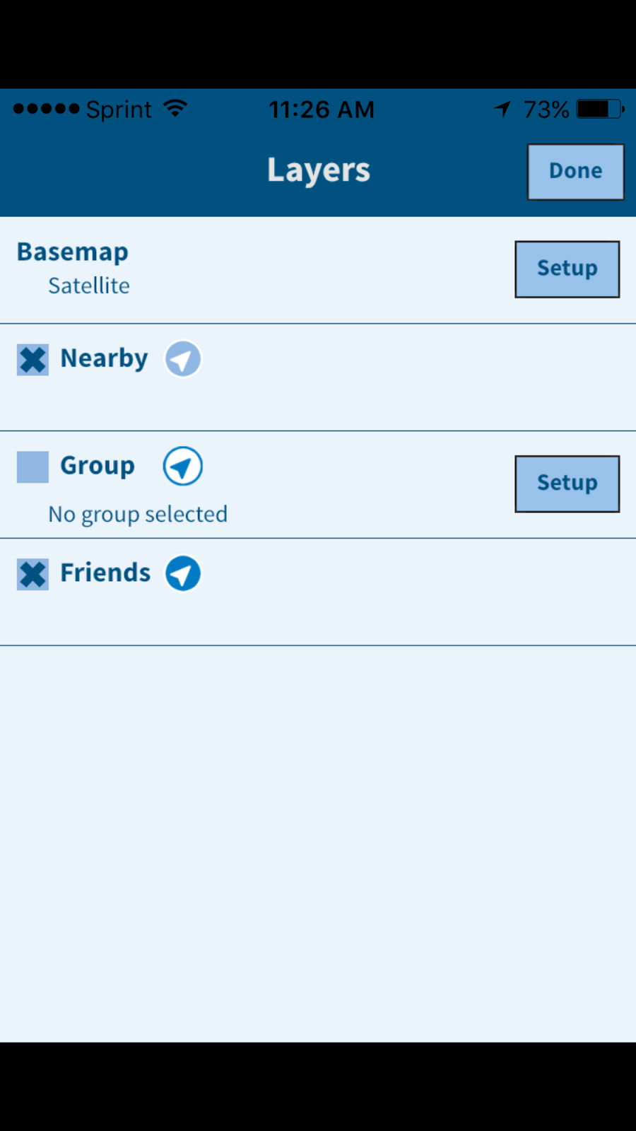
Layers:

Locations provides several new maps and charts options. There are options to view OpenStreet 1 or 2, Bing Map, Satellite, NOAA raster charts and Aqua maps.  NOAA raster charts are copies of the old NOAA paper charts which are a powerful navigation aid.

The Aqua Maps are a vector representation of the marine charts used by the Aqua Maps app I reviewed some time ago. With all these options it should be easy to locate other boaters and help aid you with some basic navigation.

Other custom base maps can be added with the setup of the Base map name and the tile server list.

More new features have been promised in the very near future.  The ActiveCaptain messaging system will be integrated with the eBoatCards system and the functionality to send, receive and archive will be made available in the Locations app.

Many of you are familiar with the DragQueen anchor alarm app. This functionality will be moved into the Locations app along with remote monitoring capabilities.

All the great ActiveCaptain crowd sourced points of interest will also be integrated into the Locations app at some point. This data will be able to be used offline in case you lose your Internet connection or are way from WiFi.

As you can see, the ActiveCaptain crew is hard at work providing all these amazing apps and features to you absolutely free.  So there is no reason not to download the app an get started today.

~~~ Sail On ~~~~/) Mark


Thursday, September 10, 2015

Swell Avantage Boating Location App

Application: iPhone, iPad, iPod Touch, iOS 8.0 or later
Function:Marine GPS tracking and location
Rating:*****
Cost: Free

Swell Advantage is a brand new app just released this summer in July of 2015. It was developed by the Novia Scotia based Canadian group called Swell Advantage, ahh!  Co-founders Iaian Archibald and Craig Sheppard wanted to develop a different kind of app to bring boaters together on the water.

I was recently contacted by Mike Hardy from Swell Advantage. He was excited about the new app and wanted me to check it out and review it if possible. I am always looking for new apps to review so I said, heck yah!  So, lets lift the hood and see what this app has to offer.

The iOS version is out now and an Android version will be available soon.  SwellAdvantage is a new and different kind of boating app at first look!  It is meant for all levels of boater to use in marine navigation and to improve the social and safety aspect of boating.

Have you every asked the question, have our friends left the dock yet? Where are they now? Are the kids jet skiing with the neighbors? Where is the raft up party? SwellAdvantage helps answer these questions for you and helps guide you to your boating friends.

The main screen at left shows your present location with the arrow and range marker. The view can be changed from North up to Course up by tapping the arrow icon in the lower left of the screen.

The Menu is accessed with the icon in the lower right of the screen.  A list of your Friends is accessed with the icon in the top right of the screen.

The app provides functionality to easily notify you when your friends are out on the water and then it provides the tools to interact and locate them if you wish. This is not just another navigation app but a tool that enables socializing with other boaters.

SwellAdvantage allows you to share your position and other data including speed and heading so you can see your friends and they can see you on the water. Boating is a social sporting activity. Many boaters, sailors, paddle boarders or kayakers like to rendezvous with each other to raft up, share stories or have an impromptu race.

I have two kids who are always on the water. This app would be a great way to keep track of them when they are out boating, sailing, jet skiing, kayaking or paddle boarding.

The app not only provides notifications locally but you can also track your friends around the world when they go boating.

The app provides the option to share your location or not. A simple flip of the switch in the Friends menu will turn location sharing off. Your location is only shared while you are on the water and it is blocked when you are on land.  This will prevent your friends from tracking you when your not boating. The app must have some locational software that determines when you are on a lake, river, pond or ocean or land.

Features:

  • Viewable Maps, Satellite and Bathymetric displays
  • Display Course, speed and drift
  • Imperial or metric settings
  • Entering water notification
  • Custom boat data
  • Invite and add friends through your Facebook contacts
  • Visually locate your friends’ locations, distances, and headings on the water
  • Receive notifications when friends and family get on their boat
  • Location tracking is automatically disabled when you're on land
  • Users can manually disable On-Water location tracking
  • Your course due to drift, speed, and heading is visually shown on the screen
  • Unique interface that puts the user at the center of their boating experience
The app is pretty basic so far.  There are hints that the authors will be adding more marine navigation and charting features to future versions of the app.  I like what they have done so far and will be patiently waiting for the next update and the addition of more functionality.

What features would you like  to see added to the app? I personally would like to see NOAA charts, tracking, waypoints and routes to start with.

There are other apps similar to SwellAdvantage in the iTune Store. Many of the big name apps have AIS locational information through NMEA WiFi or through land based AIS systems that rebroadcast position data over the Internet.

ActiveCaptain recently came out with the Locations app which I reviewed recently.  ActiveCaptain is best know for their crowd sourced points of interest website and the many charting app that have embraced their POI database. They have a bigger vision in mind which will also connect boaters much like SwellAdvantage is trying to do.

So download the app now and start building your very own social boating network of family and friends! I bet it will even work this winter when those Canadian lakes freeze over and everyone goes ice fishing. 

~~~ Sail On ! ~~~ /)

Mark

Monday, September 7, 2015

iNavX Version 4.7.0 Brings New Changes and New Ownership

If you have updated your iNavX app recently you might have notice the new logo.  The logo is not the only thing that has changed. The creator of iNavX, Richard Ray has reportedly sold his iNavX, MacENC and GPSNavX applications to NavX Studios LLC.

You can check out their new website  for a list of all the features and support links.  It is cool to see if you click on the Tutorials tab on their website it takes you to my blog, i-Marine Apps site.  All the tutorials that I did for iNavX can be accessed there.

Over the years I have written numerous articles and tutorials about iNavX for a good reason.  It is still ranked #1 on my list of Best Marine Charting apps. I hope the new owners and developers will be as engaged at Richard was with the boating community.  The MacSailing message board for iNavX is a great resource for anyone wanting to learn all they can about the app and it's capabilities.

In the past there were only iPhone and iPad versions of the iNavX. MacENC and GPSNavX were programs for iOS computers.  I am sure there are many users out there that would love to see an Android version of the industry leading iNavX app. Maybe the new owners can work on that.

Over the years I have made many suggestion for improvements to the app. One of the main things I do hope the new owners address is the xTraverse website.  It would be so much easier to download charts if the app allowed in app purchases.  The whole process of paying for the xTraverse yearly membership and then purchasing charts through the site is a bit cumbersome and frankly more complicated that is has to be. I am not sure why is set up this way but in app purchases would be a great improvement.

I will keep an eye on the new iNavX team and report any new developments. Stay Tuned!!

~~~ Sail On ~~~~ /)
Mark


Saturday, August 29, 2015

Transas iSailor 50 % Off Chart Sale

I recently reviewed the new Android version of the Transas iSailor app. iSailor is listed in my top 10 Best Marine Charting apps on this blog. It is a full featured marine charting app capable of helping you navigate rivers, lake and coastal waters almost anywhere in the world.  I have written many reviews of the app over the years since it was introduced in 2010.

I got an email recently from iSailor notifying me that they will be having a chart sale this coming week. That's right if you want to buy some charts for you new app you can get them 50% off starting September 1-15th. Not all charts are on sale. Only a limited number are half off so make sure your selecting the right ones to get this special deal.

The chart folios on sale are limited to Canada, Europe, Australia and New Zealand. With each of these charts sets costing up to $24.99 each a 50% sale could save you some serious money.

To purchase charts in the iPhone or mobile Android phone version, pull up the Tools bar from the bottom of  the screen. Tap the Gear, (Settings) icon and Select the Chart Store.

If you have an iPad or Android tablet version of the app just tap the Gear icon in the lower right of the screen and then select the Chart Store.

Simply scan around the interactive map until you find the area you wish to purchase. Tap on the price button to purchase and download.

If your in the market for some new charts this would be a good time to stock up at half price.

Happy September 50% off iSailor Charts. Wahoo!!!!!


~~~ Sail On ~~~/)Mark


Saturday, August 22, 2015

i-Sailor for Android Devices

Application: Compatible Android tablets and phones
Function: Marine charting, AIS, GPS, navigation
Rating: *****
Cost: App download is free, with in app purchase for charts $4.99 to $24.99.

Transas i-Sailor is one of the leading apps in the Marine Navigation and GPS tracking area.  I have written extensively in many post about the iOS version of their i-Sailor app since it was released in 2010. Since that time may Android users have been very vocal about wanting a version they could run on their phones and tablets. Well after much pleading and outcry i-Sailor has heard you loud and clear and responded with an Android version. You can now download it on the Google Play store.

The functionality and features appears to be very similar to the iOS version. i-Sailor has evolved to be a full featured app including charts, routes, waypoints, tracking, weather, AIS, NMEA connectivity.  The navigation screen is clean and uncluttered allowing full view of the Transas's TX-97charts.

Features:
  • Internal GPS 
  • NMEA GPS over Wi-Fi (TCP connection Bluetooth NMEA GPS through the Android Location Provide or Bluetooth GPS 
  • Display of Charts and Routes
  • North Up, COG Up and Route Up chart orientations
  • Information on any vector chart objects
  • Free cursor, Point-To-Point and Own Ship referenced ERBL functionality
  • Navigational data: Position, Course (COG) and Speed Over Ground (SOG)
  • Route creation, Go To routes
  • Bearing to WP, Distance to WP, XTD
  • Time-To-Go and ETA to any selected waypoint ahead
  • Day and Night chart background colors
  • List of supported and tested devices with Android version 4.3.x (API 18) and higher:
Compatible Tablets:
  • Google Nexus 7 (2013)
  • Samsung Galaxy Tab S
  • Samsung Galaxy Note 8.0
  • Samsung Galaxy Tab Pro 8.4
  • Samsung Galaxy Note 3
  • Sony Xperia Z2 Tablet
Smartphones:
  • Samsung Galaxy S4
  • Lenovo S60
Other phones and tablets may be compatible but this is the list that i-Sailor had on their website. i-Sailor Android had GPS functionality that allows the user to select the onboard GPS of the phone or tablet. It also has the options of selecting NMEA and Bluetooth GPS options. The NMEA option is available for a $9.99 in app purchase. 

Charts:
The first thing you will want to do is download some charts. i-Sailor offer a wide variety of charts for most locations in the world. 

Select the gear icon to access the Settings Menu. From there select the Purchase Charts option to access the chart store. Charts range in price from $4.99 to 24.99. I downloaded the USA Gulf Coast Florida charts for $4.99.  The full list of Caribbean charts will run you $24.99.

The main chart and navigation screens are laid out nicely. The tablet version is shown in the image on the left. Selections for track up and north up are in the upper right of the screen. Indications for position information, latitude and longitude are displayed in the upper section also.

Course over ground, (COG) and speed over ground (SOG) are two of the most important navigation features most boaters need.

Waypoints and Routes:

The app has the ability to create routes with waypoints for more in depth navigation options. To create a route go to the Route icon in the Tools section. Select New Route, you will note that a waypoint box pops up on your screen. Place your finger on the waypoint and move it to the desired location. The latitude and longitude are displayed as you move the waypoint.  Select the Green + when you have it at the location you want. Tap the screen again to create another waypoint in your route. Continue doing this until the route is complete.

Navigating a route is one feature that not all marine charting apps have. i-Sailor provides this functionality and show Bearing to waypoint (BTW)and Distance to waypoint (DTW) along with Cross track error (XTR). Other navigation features include estimate time of arrival (ETA).

NMEA Options:

One of the most powerful features of i-Sailor Android is its ability to connect wirelessly through WiFi or Bluetooth to onboard instruments and external GPS devices. NMEA GPS can be accessed with an in app purchase of $9.99. This will unlock compatibility to receive GPS over WiFi connections through TCP and UDP protocols for the GGA, RMC, GLL and VTG sentences.

NMEA Compass rotation, Wind Sensor and Echo sounders can also be purchased for $4.99, and $8.99 each.  This level of connectivity with your onboard instruments give the app the information it needs to be a full fledged navigation chartplotter.

Wi-Fi Connection to an external AIS sensor is also provided with an in app purchase. This will allow the display of ships in your area on your mobile device. You will need to have a AIS receiver unit onboard capable of broadcasting the AIS data over WiFi to be able to receive this data.  

The Android version of the i-Sailor app is a welcome addition to the Google Play Store. I know the release of this version has made many Android users happy to finally have this app available to them. Please comment and let me know if you are using the app and how its working for you!

~~~ Sail On ~~~ /)
Mark