 I reviewed Jeff Siegel's Locations app back in June of this year. I would have though he would have taken the summer off to enjoy some of that great Maine weather. Instead, he has been busy adding some great new features to his Locations app.
To get started you will need to get an ActiveCaptain account which you can then use to login to your eBoatCards account. Not sure why they require two accounts, it would be much easier if there was only one log in and account required. The account is free so just sign up once to register.
New Features:
- Session Mode selection of Send and Receive or Receive only
- Layered base map overlays
- Group layers
- Signal K support
- Menu selections for Settings, Layers, Messages and Help
- Scrollbars setting for desktop version
- Dot Icon for member location data older than 24 hours
- Graphic display of boats current course in the Search(magnifying glass icon)
- Bing, OpenStreet, Satellite, NOAA charts and Aqua Maps base map layer options
 The Locations app is not only available for you mobile device but is also able to run on PC, iOS and Androind devices.
The first thing you will notice new about the app when you start it up is the selection of a session mode. At this point you can choose to Send and Receive locations or just Receive Locations of friends and not upload your position. This is just another level of security that was added to the app. You can always change this mode by going to the Settings menu and selecting Session Mode to change it later.
Your GPS location is shown on the map as an arrow icon. If no GPS location is being received the icon will display red.
The icon will display dark blue if your device is receiving GPS and sending your location.
The icon will display white if your device is receiving a GPS signal but not sending your location. The option to send your location or not can be set up with the session modes.
 Find:
Find: The Magnifying Glass icon in the lower left side of the main screen activates the new find feature and options.
This is used to find other eBoatCard users and your boating friends. Options can be selected to show your friends, groups, nearby boats and stationary boaters.
Nearby members that are within a 5 mile radius will be shown with as a light blue icon with a white boarder. Group boater icons will be shown as white with a dark blue border. Friends will be shown as dark blue bordered by white.
Tapping any of the icons will show the latest information received from that member. Tapping the bolded boat name will open up their eBoatCards data in a separate web browser.
The Search bar will help you quickly locate boaters by simply typing in their name.
 Your list of friends will be listed in the lower section and can be sorted by name, distance and data age. As you can see I just have one friends so far. Jeff was nice enough to accept my friend request. Requesting Friends is done in the eBoatCards application and is much like requesting friends on FaceBook.
Settings:
The new menu button now shows selections for Settings, Layers, Messages and Help.
The Settings section provided selections to change some of the display options, sounds, units and GPS data. The display options include selections of large, medium or small user interfaces. This is great for many of us old boaters who need larger text. The Keep On options lets the app remain on and not go into sleep mode. This will constantly display the screen so make sure your device is plugged and charging to prevent your battery from running down.
The + and - zoom buttons can be togged on or off. If your are familiar with the pinch to zoom feature these are really not needed.
The Follow mode has options for Course up, Heading up and North up. These change the orientation of the icon to the map or displayed chart.
Sounds can be toggled on or off to alert you when friends, groups or nearby boats are located.
There are options to select metric or English units for distance, depth, height and location.
The app allows the use of your devices internal GPS or options to select NMEA 0183 or Signal K over WiFi. Locations has the ability to show your location using the DeLorme and SPOT satellite location devices. These are set up in the eBoatCards website.
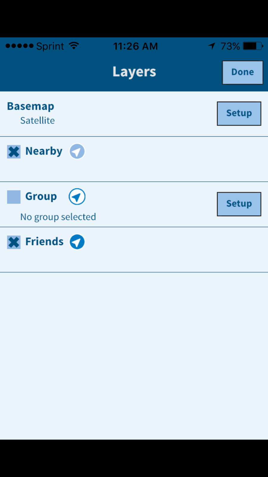 Layers:
Locations provides several new maps and charts options. There are options to view OpenStreet 1 or 2, Bing Map, Satellite, NOAA raster charts and Aqua maps. NOAA raster charts are copies of the old NOAA paper charts which are a powerful navigation aid.
The Aqua Maps are a vector representation of the marine charts used by the Aqua Maps app I reviewed some time ago. With all these options it should be easy to locate other boaters and help aid you with some basic navigation.
Other custom base maps can be added with the setup of the Base map name and the tile server list.
More new features have been promised in the very near future. The ActiveCaptain messaging system will be integrated with the eBoatCards system and the functionality to send, receive and archive will be made available in the Locations app.
Many of you are familiar with the DragQueen anchor alarm app. This functionality will be moved into the Locations app along with remote monitoring capabilities.
All the great ActiveCaptain crowd sourced points of interest will also be integrated into the Locations app at some point. This data will be able to be used offline in case you lose your Internet connection or are way from WiFi.
As you can see, the ActiveCaptain crew is hard at work providing all these amazing apps and features to you absolutely free. So there is no reason not to download the app an get started today.
~~~ Sail On ~~~~/) Mark
This comment has been removed by a blog administrator.
ReplyDeleteıldır transfer
ReplyDeletegüzelbahçe transfer
foça transfer
mordoğan transfer
aliağa transfer
UAD