
Application: iPhone 3,4,5, iPad, iPod Touch iOS 6.0
Function:
Marine GPS Navigation and Charting
Rating: *****
Cost: SEAiq USA $9.99, Free version, SEAiq Open $19.99
Mark Hayden, the author of the SEAiq series of apps, has been very busy lately. He has not only sailed more than 15,000 miles this past year but also has made many valuable additions to his SEAiq charting app. I originally reviewed the SEAiq USA app back in April of 2012.
Mark and his growing family arrived back at their boat in Australia with an added crew member this year. Their son joined them as they spent many months exploring the coasts of Australia and eventually moving on to Southeast Asia. Concerns about pirates forced them to cross the Indian Ocean and onto South Africa. The last leg of their trip was from South Africa to Cape Verde where the boat will remain until baby number 2 arrives shortly. They plan to continue their adventures in the Mediterranean. Congratulations Mark and Dana!
You can follow all of their travels on their Northfork blog.
Mark's many ocean miles have given him a unique perspective on what features are valuable for crossing oceans as well as coastal cruising. He happens to be an accomplished sailor and a very talented programmer. This combination has produced one of the best charting apps on the market today.
The latest additions to SEAiq have added more functionality to the already feature rich app that is becoming the Go-To-App by many boating enthusiasts and harbor pilots. The variety of features and the versatility to display just about any type of chart make it a must have app.
Features:
- NOAA ENC Vector
- NOAA Raster charts
- US Army Corps of Engineers vector chart of inland waterways
- For SEAiq Open formats include, KAP and BSB formats, S-57, S-63, Inland-ENC, CM93, and KAP/BSB plus home-made charts generated from satellite imagery
- Offline use of charts
- Night time color modes
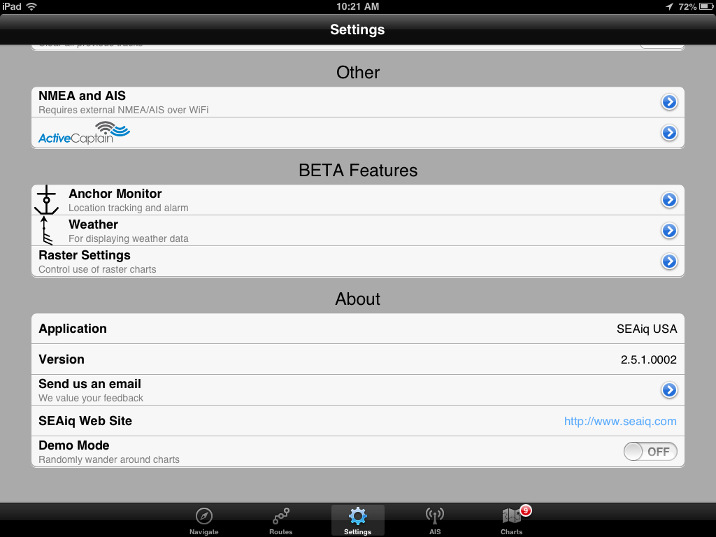
- ActiveCaptain points of interest
- On screen instrument display
- iPad vertical instrument display
- LAT: Latitude, LON: Longitude, ACC: Horizontal Accuracy of current GPS fix, COG: Course Over Ground, SOG: Speed Over Ground, BTW: Bearing To Waypoint, DTW: Distance To Waypoint,VMG: Vector Made Good
-
English and metric units
- Import/Export
- Detailed Vector chart information
- Waypoints creation and edit
- Route creation and edit
- Tracking
- Smooth chart quilting
- World chart view
- Multi-touch gestures, pan and zoom
- NMEA WiFi instrument and AIS data
- AIS display
- Weather Grib downloads from the Internet or Saildocs via Sailmail
- Wind, pressure isobars
- Anchor Alarm
- 7 Day evaluation period
- Drag and drop Variable Range Markers
- Drag and drop Electronic Bearing Lines
The premium features will no longer be available after the 7 day trial period. They do allow you to un-install the app and reinstall it for another 7 days if needed.

Chart Types:
SEAiq has a very wide range of charts that can be displayed. Unlike most charting apps many of the charts can be downloaded and updated for free. For SEAiq USA and SEAiq Free, both raster and vector charts and updates can be downloaded free from NOAA within the app. Vector charts for inland waterways published by US Army Corps of Engineers are now available too. The app allows you to switch back and forth between displaying the raster or vector types of charts. The Raster setting in the settings menu will switch the viewed charts between Vector and Raster.
For the SEAiq OPEN version, you can load charts in the KAP and BSB formats. SEAiq OPEN now supports formats including S-57, S-63, Inland-ENC, CM93, and KAP/BSB. Many of these can be downloaded from the Internet and imported using the Open In feature. Support also includes home-made charts generated from satellite imagery. This is useful for areas that do not have good chart coverage. The OPEN version is free to download and with an in app purchase of $19.99 it will upgrade to the premium version with all the features. No other app allows you to download and use so many different chart types.
Mark provides links to many free S-57 chart sources within the app's help screen. (See below). Help for downloading other types of charts is also explained nicely within the app.
NOAA provides high quality charts of the USA and territorial waters:
http://www.charts.noaa.gov/
The US Army Corps of Engineers provides charts of some inland waterways in the USA (in both S-57 and Inland ENC formats):
http://www.tec.army.mil/
Numerous charts of inland waterways in Europe. Below are some of the links. Note that these links change from time to time:
Austria: http://www.doris.
Belgium: http://ris.
Czech Republic: http://193.86.76.
Germany: http://www.elwis.de/
Netherlands: http://www.
Romania: http://www.afdj.ro/
Serbia: http://www.plovput.rs/
South China Sea (requires registration): http://scsenc.eahc.asia
Status Bar:
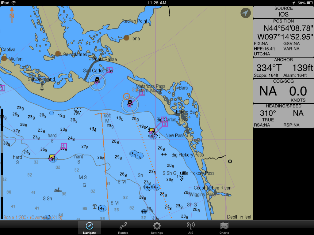
Another new addition to the app is the Vertical Status Bar. This is available for iPad versions when in landscape mode. When you rotate the app into landscape mode the status bar will move from the top of the display to the side of the display. The data is now organized into more logical groups for display. The GPS position and senor data is separated and shown on top. The SOG and COG readings are displayed using a bigger font which makes them stand out and easier to read.
Context-sensitive information is also displayed when certain features are turned on so you only see the data when it is useful to you. When the anchor alarm in enabled, the information about relative position of the anchor is displayed. When AIS is being used, information for the most recently selected target is displayed.
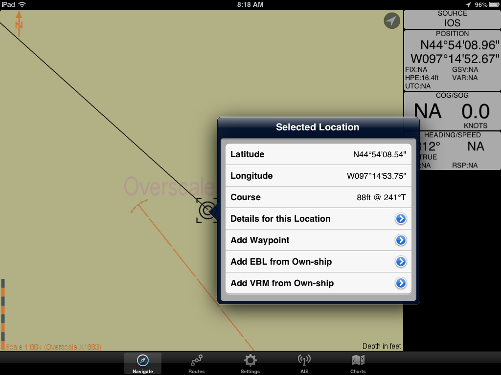
Variable Range Markers and Electronic Bearing Lines are some new tools added for measuring distance and bearing. These can be added to you chart by simply double tapping at any point and making a selection. The VRM tool allows you to specify a distance around your present location or a point. A circle is then displayed at that radius.
EBL can be made from any point on your chart to another point or location. It will display the bearing and distance between the two points. This feature is nice to quickly find distance and bearing from your own-ship or even to an AIS target. These can be dragged and dropped onto or off of a vessel.
One of the latest additions to SEAiq is the weather data including Wind, Pressure/Isobar data. It has the ability to download this data automatically from the National Weather Service. An Internet connection is required. This latest release adds the pressure/isobar lines. The weather data can also be downloaded manually while underway via SailMail/SailDocs using your SSB. Additional weather data is planned for future releases. The settings menu in the Weather sections lets you control what data you want to see and how it is downloaded.


~~~ Sail On ~~~ /)
Mark
This comment has been removed by a blog administrator.
ReplyDeleteThanks for the review. We just released version 2.6.0 of SEAiq Open and will release 2.6.0 for the other apps over the next several days.
ReplyDeleteThe biggest change is that our SEAiq Free and SEAiq Open apps now allow viewing all charts regardless of chart scale. Previously, viewing harbor-level charts (<1:50,000) required purchase of the in-app upgrade. The SEAiq apps are the ONLY iPad apps to provide FREE chart coverage for the USA and internationally.
Other changes:
* Lots of performance improvements.
* SEAiq Open has been tested to support:
* UK Hydrographic Office entire catalog of S-63 charts
* Free raster charts published by the Brazilian Navy
* Free raster charts published by the Argentine Navy
* Many users have sent us raster charts they use and we have fixed all related issues
* If you have any charts that SEAiq Open can view, please email us...
regards, Mark
Mark,
ReplyDeleteThanks for the update on the app's progress. Glad to see you are continuing to make additions to your already very useful app.
The additional charts for Brazil and Argentina should make your South American users happy. Your app continues to be the most versatile and able view many types of charts from all over the world.
Mark
SEAiq has updated the pricing of their apps as of November 1, 2013. These prices are still very reasonable for the vast number of features and charts that are provided with the apps. SEAiq is now listed number 2 on my list of best marine charting apps.
ReplyDeleteSEAiq Free is the only app that automatically downloads and displays all vector and raster charts published by NOAA and US Army Corps of Engineers. SEAiq USA is the same as SEAiq Free but can be purchased with all features with an in-app purchase.
SEAiq Open is for international use. It is the only app that allows download of your own S-57, S-63, iENC, CM93, and BSB/KAP charts on your iPad/iPhone.
SEAiq Pilot is the only iPad app designed for use by river and harbor pilots. It supports the same chart formats as SEAiq Open, and has support for additional features include: docking aids, bathymetric ENCs (bENC's), manual tidal adjustment, AIS meeting point, and GPS diagnostics
•SEAiq Pilot: US$249.99
•SEAiq Open: US$39.99
•SEAiq Free: US$24.99
•SEAiq USA: US$24.99
Mark