 Application: iPhone 4, 4S, 5, iPad, iPod Touch>3rd gen, iOS 5.1
Function:
Rating: **
Cost: $1.99
Jens Christensen is a sailor like some of us and out of a need to do some marine calculations he created a slick little app called Marine Tool. He pointed out that it is tough sometimes to do calculations underway on a pitching boat. Having an app handy on your iPhone or iPad can save you from looking for a piece of paper, pencil and a calculator to do the calculations.
 With his latest version of Marine Tool 1.3 he has added the Navigation page, Distance between two coordinates and Course correction. He has also developed the Marine Tool website to support of his work.
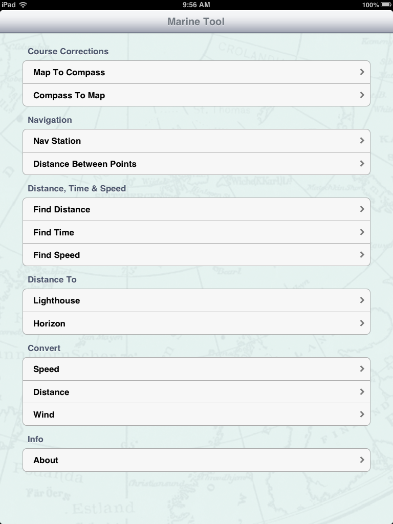
The app is separated into five main areas. Course Corrections, Navigation, Distance-Time-Speed, Distance To and Conversions.
The main screen is shown to the left. To make a calculation simply select by tapping the line to enter the calculation page for that value.
Values are easily typed in using the on screen keyboard and multiple units can be selected on each page.
Features:
- Course calculations taking into account speed and direction of the current
- Latitude
- Longitude
- SOG
- COG
- Magnetic North
- True North
- Time, Date
- GPS accuracy
- Distance and bearing calculations
- English and Metric units
- Time and distance calculations
- Lighthouse and horizon distance
- Speed conversions between knots, KM/h and MPH
- Distance conversions between nautical miles, kilometers and miles
- Wind conversions between meters/second, knots, MPH, KM/h and Beaufort scale
 The Course Correction page allows you to easily make calculations related to the effects of wind and current on your yacht's heading. The Map to Compass selection lets you enter the speed and direction of the current and leeway affects of the wind and provides you the adjusted course to steer to maintain your heading.
The Compass to Map selection lets you enter your compass course, current speed and direction and boat speed. It then calculates your true heading and speed advance.
I like that the calculated values are shown on top of the display for easy viewing.
 The Navigation section has real time readings from your devices on board GPS. It provides latitude, longitude, speed over ground, course over ground in magnetic and true readings. Date, time, altitude and GPS accuracy are listed also.
 Units for the various readings can be changed by tapping the arrow on the right side of the screen. Change between knots, KM/h, MPH or meters/second.
I like the data provided but I would like to see the compass heading, SOG and COG with the option to display these in large segmented displays to make them easier to read for us old guys who can't see the small type. The addition of trip mileage and trip time would be a nice addition too.
Another feature I would want is some kind of marine charts to show the user's position. NOAA charts or Google maps would be a nice additional feature.
The Distance Between Points is also part of the Navigation section. Simply enter two GPS locations and the app will calculate the distance and bearing to the second point. Distance can be shown in knots, kilometers and miles. It would be nice to have the first point default to the users present GPS position. Most of the time I would want to calculate the distance between my present position and a destination location. This would also speed up the data entry.
The last position data and calculation is saved in case you want to return to the calculation page.
 Distance,Time and Speed calculations can be made in the next section.
The three different sections allow you to calculate the third value knowing two of the three.
For the Distance calculation we enter the time of travel and the speed to get the distance travelled.
For the Time calculation, enter the Speed and Distance and the time is calculated.
For the Speed calculation, enter the Time and Distance to get the speed.
All units for Speed and Distance can be made in metric and English units.
Distance To calculator is the next section. Marine Tool easily calculates the distance of an object in this case a light house if you know the height of the object. The horizon can also be calculated with the known height of the the observer. Units can be selected for English and metric units.
 Convert is a very useful section to covert just about any nautical value to various units including English and metric values.
Speed can be converted to any of the values including knots, KM/h and MPH. Simply enter the value and the desired units and Marine Tool make the conversion, whiz bang easy!
Distance can be converted between nautical miles, kilometers and miles.
Wind speed can be converted between meters/sec, knots, MPH, KM/h and a Beaufort scale number. With each wind value come a description of the expected wave height, land and sea conditions.
The author of the app has reported that version 1.4 is already in the works. Some additional features that it will include are logbook features with advanced statistics and more calculations related to GPS coordinates and a few extra converters.
This app puts together many of the common calculations needed by boaters. I can only see this app improving with the planned future additions. It will definitely be one of the apps I add to my marine app toolbox. Check it out for the great price of $1.99!
~~~Sail On ~~~ /)
Mark
Can it also convert D°M.M to D°M'S", D.D and vice versa?
ReplyDeleteAnonymous,
ReplyDeleteThanks for checkin out the blog! It does not covert the position, but it does have a setting to change the display of the position in DDD.DDDD, DDD MMM SS or DDD.MMM.MMMM
Under Navigation, select Nav Station. Select either latitude or longitude to specify how it is displayed.
Hope that helps
Mark
I truly appreciate how you’ve worded your material in this article. I am very impressed with this information and you’ve managed to keep it interesting.
ReplyDeleteMarine College
Excellent. Worth Sharing & Guiding. Hats Off..............Marine engineering training in HIMT Collage trained both theoretical and practical,during the first and final year of the course. Top marine course in HIMT Collage.
ReplyDeleteBest Marine Colleges In India
As a Marine College professor, I found this post very useful for Marine students, keep posting info like this. Kindly let me know how to subscribe for this blog because i need regular marine updates like this from you. Keep touch with my websites gp rating best college in tamilnadu | gp rating training
ReplyDeleteThank you for posting this blog. It will be useful for Marine students.
ReplyDeleteTop Schools In Coimbatore
Your Content is amazing and I am glad to read them. If you are familiar with SEO, you already know how important Links Building. If a link relation is given as dofollow, then you will get a good boost over SERP and Boost your Ranking Buy Services From it 24/7
ReplyDeleteunique 35 article submission high 40 da backlinks
top rated classified website Ads
Wordpress Shopify Wix On Page SEO services
This comment has been removed by a blog administrator.
ReplyDelete