Function: Marine navigation, planning and charting
Rating: ****
Cost: App is free, charts purchased in the app
Jeppesen navigation has been around for years providing aviation and marine navigation and charting systems. They are a Boeing company, perhaps you have heard of them. Their C-Map products have been a industry standard for years. The Plan2Nav app is their latest marine planning and charting app. The app is free to download and comes with a worldwide base map for planning purposes. Additional charts can be purchased within the app.
The app was just updated on October 19, 2011 to version 1.0.3.
Features:
- View charts in perspective mode
- Enable the GPS to view
- Speed Over Ground (SOG)
- Course Over Ground (COG)
- Estimated Time of Arrival (ETA)
- Time To Go (TTG)
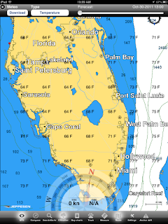
- Download the free weather and see a five-day forecast overlaid on the chart
- North-up, Course-up: fully rotating visualization
- Distance Unit, Clock and Compass
- NavAids
- Detailed harbor charts
- C-Marina port database
- Dynamic tides and currents
- Photos and diagrams
- Depth and land elevations
- All downloaded charts stay recorded on your iPad and are accessible even when a wireless connection is not available.
The rest of the app features are accessed on the bottom of the screen with the soft keys. Realtime GPS, Compass, Search/go to, CWeather, Buy charts, Track, Measure, Route, Settings and Anchor drift.
Weather can be downloaded and includes temperature, humidity, wind and waves. A handy slider at the top shows forecast weather data out five days.
Screen orientation can be changed using multi-touch commands. The view of the charts can be changed to show other orientations.

The compass soft key brings up a navigation display which shows the GPS status, SOG, COG, Latitude and longitude and a dynamic compass.
Plan2Nav has a nice professional look an feel to it. It has many features that are required for marine navigation. The charts are very detailed and allow the user access to the data needed to be confident while navigating.
I found it very intuitive to use and was able to download weather, navigate in realtime, make measurements, create tracks, and routes without to much effort.
I am so impressed with the app that I am moving it into the number 3 spot of my Top 10 Best Marine Charting Apps.

Additional charts can be purchased in the chart store. Both lakes and marine shoreline charts can be downloaded by using in app purchases. Charts prices vary depending on the area and selection.
Additional features include a tracking feature which will track your boats course. A measuring feature allows you to measure distances on the chart for planning or on the go navigation.
Routes can be created by simply tapping and holding a point on the map. Points are marked and displayed with pins.
Settings allow you to change between different units of depth, distance coordinates, speed, temperature and fuel consumption.
If nothing else download the free Plan2Nav app and take it for a test drive. I think you will find the Jeppesen has a winner here. The next step is to download a detailed map of your region and explore the rich detail, photos, charts, tides and information available.


This comment has been removed by a blog administrator.
ReplyDeleteJeppeson site doesn't tell me what the cost of the program, or the charts, is - - - I'll stick with Mariner MX for now.
ReplyDeleteAnonymous,
ReplyDeleteThe app is free but the charts can be purchased between $20 and $50 through an in app purchase depending on what chart set you want.
Mark
This comment has been removed by a blog administrator.
ReplyDelete