Friday, July 27, 2012

Marine Map Navigator

Application: iPad, iPhone 4, iPhone 3GS, iPod Touch 3rd and 4th Gen
Function: Marine Charting and Navigation
Rating: **
Cost: $9.99

Well I survived the Jimmy Buffett concert in Chicago and the 4th of July celebrations and my niece's wedding in Colorado the past few weeks. I guess it is time to get back to work and tell you about some more great, geeky apps for your mobile devices. 

More charting apps are hitting the market these days and new features are constantly being added to the apps already out there. One new app I ran across today is called Marine Map Navigator.  Many of us who have been looking at charting apps have seen many apps use the NOAA Raster Charts.  These charts look like the old paper charts and have many limitations for displaying and viewing additional data.

Marine Map Navigator has taken a new direction and is one of the few apps to use Vector charts which can be downloaded for free from NOAA ENC.  This is a collection of about 1000 charts that cover the coastal areas of the US, Puerto Rico, US Virgins Island and the Hawaiian Islands.  The app will load and display and ENC charts in the S-57 format.

Features:

  • Free NOAA ENC S-57 Vector charts
  • Paid Canadian and United Kingdom Hydrographic charts
  • International Hydrographic Organization charts
  • Multi-touch gesture navigation
  • Compass
  • GPS display of current position
  • Weather Data
  • Tides
  • AIS
  • Speed and heading
  • Waypoints and Routes
The feature list looks pretty inclusive of all the needed functions to navigate with your iPad.  The screen shots on the website don't seem to match the ones on the iTunes Store, not sure what is up with that. They may be from a previous release.

The splash screen shown at left comes up when the app is loaded. Here you can press Start to bring up the previous chart from your last session. Select Open Set if you want to select another chart. Open File will show you the recent files you have opened and allow you to select one of them. It appears to only load one chart at a time. Quilting of the charts would be a nice added feature.

Open Set will display a list of NOAA charts for you to select and manually download. Pick the chart you want and the file will be downloaded and installed automatically.

The app requires that you have access to the Internet or WiFi to download the charts to your iPhone or iPad. Once they are downloaded you can use them offline.


The first screen shot shows five tabs across the top listing Charts, Compass, Weather, Tides and AIS.  Additional buttons on the bottom of the display show Real time Position, a Measuring function, Navigation Lights, Waypoints, Routes, Layers and a menu selection. 

Selecting the Compass display will overlay the compass on the chart. The compass rose is shown with readings to 5 degrees. Speed, Heading and coordinates are shown in the bottom panel.


The Weather and Tides features require that you have an Internet or cell connection to download data. The tides and currents are from the website http://tbone.biol.sc.edu/tide/.

The weather tab just brings up the National Weather Service  page for the area you are viewing on the chart. This is a great site for forecasts, radar, satellite images and more. This is handy feature that lets you view weather from within the app rather than bringing up another app to check the weather.


The AIS screen also uses the Internet or cell connection to bring up the website http://www.vesselfinder.com/  This is not true AIS but a land based AIS site that rebroadcasts locations of vessels for you to see on the web.

The site shows it has about 29000 ships listed for viewing.  I am not sure what kind of coverage they have around the world so make sure to check your areas for coverage.


Waypoints and Routes can be created and saved under the Arrow menu key on the bottom right of the screen. To create a waypoint select Create Waypoints from the menu. Then tap the screen to create a waypoint. The keypad will then come up to allow you to name the waypoint. A color selection box will also pop up to allow you to make your waypoints different colors. After you have selected the color, save your waypoint.

Here I have created three waypoints and labeled them with different colors. A list of waypoints is shown at the bottom of the screen.

Selecting the Routes button from the bottom of the display allows you to create a route.  The waypoints that we created earlier can be selected and put into a route.  Save the route and the next time you select Open Route the new route will be displayed.

The measuring feature can be selected by tapping the second button from the left at the bottom of the screen.  With this selected you can tap on the screen and a pop up bar will show you the distance from your current location. It would be nice to have the heading to the waypoint shown also.

The next button on the bottom of the screen looks like a lighthouse. Select this and the chart will show you all the flashing beacons and lights in the area. The lights will actually flash on the chart. This is kind of a cool feature but if there are alot of lights in the area it can be distracting.

The layers button, second from the right on the bottom, allows you to turn off and on different features of the map. Once the button is selected a list of features will display. The default is that they are all on and will be shown in "Green" to turn off a layer simply tap it and it will turn "Red".

It takes some messing around with these features to understand how they work. It would be nice if the developer had a tutorial or more help online. As with most developers documentation always seems to come last.

The app appears to have some nice features. I like that it uses the NOAA vector charts and that the charts are stored on the device.  Waypoints and Routes are crucial to having a full featured navigation app. 

It is a little awkward working with the waypoints and routes at first. I did have some performance issues and the app did crash a few times while I was using it. It was very slow in responding to changes in zoom levels and in response to multi-touch gestures.  It is an early release and I can only hope the author works on improving the performance.

Has anyone purchased or used this app?  Any feedback from you readers would be appreciated.  I you are looking for an entry level app give it a spin.  There are a few bugs to be worked out so I am looking forward to future releases.

Sail On
Mark


Monday, July 2, 2012

Jimmy Buffett - Lounging at the Lagoon Tour 2012

Sorry for the lack of an app review this week. My family and I just got back from a great weekend in Chicago.  It was a gruelling 12 hour drive over and back but it was worth it.  We partied with our 30,000 friends of the Parrothead nation, also known as Jimmy Buffett fans.  The concert this year was held at Tinley Park's First Midwest Banks Amphitheatre.  It is an open air outdoors venue which is the only way to see Jimmy and Coral Reefer Band.

The picture is of my friend Scott and myself with some new friends who call themselves the Flamingo Sisters. You can find them on Facebook.

This has been a family tradition for us for many years. Our kids have grown up listening to Buffett music all their lives, so they know the words to most of his songs. It is part of their required education growing up in the Messerli home.

As a sailor myself, I have been listening to Jimmy since about 1976. Back then he was on cassette tape and vinyl albums. Some of you kids out there don't know what those are. My first Buffett Concert was in 1991 in Denver and I have been hooked ever since. 

Buffett and his band provide a unique concert experience the is unmatched by anyone in the business.  His legion of Parrottheads show up early and the party gets started by tailgating in the parking lot. Many venues open as early as 8:00 in the morning which allows for a full day of carninval like activities.  This year the gates opened at about 2:00 PM, so we had to pack all of our fun into about 6 hours prior to the 8:00 PM concert.

Over the years we have tried to perfect the tailgating experience. To be a true tailgater you have to be prepared for a full day of fun.  Some of the basics required are a cooler, a tent, a bar, a grill, a pool and whatever else you can dream up to make the day enjoyable.

Coolers

Coolers come in all shapes an sizes, I would suggest a large one with wheels.  The wheels will allow you to move it around easier or ride it. We found a few other modified versions which are shown here.
Cooler Trike

Cooler Grill combination
Bars

Some folks get by without a bar, but to be in the big leagues of tailgaters you will need a bar.  You will find many types of bars from just a table to some that are ornate and covered with palm fronds.
Palm frond version

Beautiful Teak bar

Tents

The weather this year was extremely hot.  To keep the sun off of you and to keep your beverages cool you will need a tent.  We purchased an E-Z Up brand which provide us with alot of space for our pool and friends.
Grills

While your tailgating you will need to eat. So a nice grill is needed to cook up some Cheeseburgers in Paradise. My wife surprized me on my birthday this year with an authentic Margaritaville Grill complete with articulating tailgate hitch. This is the ultimate tailgating accessory!
Pools

Temps this years during the concert were in the 90s. To keep from getting heat stroke we brought our trusty pool.  Others cool off with dunk tanks or a big sippy slides.
LandShark infested pool!


As you can see, tailgating is a real big deal for us at the Jimmy Buffett concerts.  I think his concerts are so popular because he provides us an escape from the world's problems, even if it is just for a few hours.  Not once did I think about the world economy, the finacial crisis, the election, my dwindling 401K, our national debt or the housing crisis while I was at the concert.  All those problems just melt away as we listen to his music. For a few short hours we get to get on board with Jimmy and he takes us to that magical place called Margaritaville where the weather is always perfect and the beer is always cold!

If you ever get a change to go to one of his concerts, I highly recommend it. It is a life changing experience!  I hope everyone has a great 4th of July celebration wherever you are.

~~~Sail On~~~
Mark

Sunday, June 24, 2012

iPad Onboard - Navigation

In my iPad Onboard Series of posts I have tried to cover a few ways for you to get the most out of your iPad while using it onboard. I talked about ways to protect your iPad, ways to use it to capture your photos and video and most recently the entertainment value of the iPad. In this post I want to cover the navigation aspects of the iPad.

The iPad WiFi, iPad2 3G and iPad3 4G(new iPad) can all be used for navigation purposes. Some models have limitations so make sure you understand which model you have.

Apple has put so much technology into these devices so they are well suited for use on your yacht. GPS, Locational services, WiFi, compass, accelerometer, Bluetooth, rotating screen, mult-touch gestures, multitasking and retina display. All of these features make it one of the most popular and versatile pieces of electronics ever built.

GPS Options
To get started navigating you need a GPS and a charting program.  The WiFi only models of the iPad do not have a GPS chip, so you will have to purchase an external GPS unit to link to your iPad. I have a whole section of my blog dedicated to reviewing the different external GPS devices.  Refer to this and purchase one of these to give your WiFi only iPad GPS capability.  The Dual XGPS150 is very popular and will cost you about $99 on Amazon.com. It uses Bluetooth to connect to your iPad and provides reliable GPS coordinates. It now comes with a 12V adapter which means you won't have to worry about the battery running down.

If you have a 3G or new 4G model of the iPad your are in luck. The device has an onboard GPS that will work with locational services to provide any GPS app the data it needs to find your latitude and longitude anywhere in the world.  Apple refers to their GPS as assisted GPS. WiFi and a cell connection are not required to get the GPS to work but if they are available the GPS will pick up a signal quicker and the accuracy will be improved using cellular triangulation.  I recently had a question from a lady wanting to know if the GPS would work without WiFi and a cell data plan.  Yes it will, you do not need either of them to use the GPS on your iPad 3G or 4G versions.

Charting Apps

At this point we are now ready to look at navigation apps.  There are many apps in the AppStore available for marine navigation.  The reason I started this blog was that I had trouble deciding myself which apps would be best to use.  After looking and all the possibilities I figured others might be having the same problem.  I have looked at hundreds of apps and have narrowed down the Best Marine Charting Apps for you. This is a list of my top 10 charting apps.

You will find that charting apps will have a wide variety of features. The more features generally, the more you will have to pay.  High end apps will cost you $49.00 and low end can cost you as little at $5.00.

Features that you should consider when looking at apps are chart type, waypoints, routes, tracking, instrument data integration, charts overlays, satellite views, AIS, anchor alarm, compass, weather, GRIB files, tides, points of interest and social networking.

Charts are a big consideration. Many apps use the raster charts from NOAA.  The raster charts are scanned versions of the old paper charts many of us are familiar with.  These charts will cover most of the coastal US, the Great Lakes region, Puerto Rico and the Virgin Islands.  These are free to download from NOAA, so most app developers don't have that expense of charts.  Vector charts, which I prefer, have many advantages over their raster predecessor.  Vector charts can imbed more information and colors which can be revealed as you zoom in to a specific area.  I wrote at length about the Perfect Marine App is this post. There are many apps, with many price ranges and many levels of users out there. I can make recommendations to you but you will have to decide what charting features are important to you.

On the high end, iNavX and Navionics HD will cost you about $49.00. I give the edge to iNavX here for their incorporation of TCP/IP connectivity for your onboard instruments. Both apps use high resolution vector charts. iNavX can use either the free NOAA raster charts or a variety of vector charts sets.

Medium priced apps like Navimatics and EarthNC use NOAA charts. Navimatics Charts and Tides gets the nod here. It has the Active Captain database and all charts reside on the device. Earth NC requires a cell connection for some of their overlays and features to work.

Low priced apps Transas iSailor and SEAiq are in the range of $5.00-10.00. SEAiq uses vector charts and does a better job with waypoints, routes and tracks. iSailor also has vector charts but does not handle waypoints very well. Mark Hayden is passionate about his app SEAiq and is a big believer that vector charts are better.

Garmin is working on their marine version of an app that is suppose to be out this summer. I am sure it will give some of the high end apps a run for their money.  The price of the apps are all fairly cheap. I find that I use several of them depending on what I am doing on the water.
 
iPad Mounts

Now that we have the iPad set up with your charting app we need to find some way to mount it.  We want the iPad secure so it will not be thrown around the boat when your rolling down that 30 foot wave in the southern ocean.  I have been in search of the perfect mounting system. Here are a few that I have found. 

MudulR case and mounting system has several mounting options that may work for the iPad on your yacht. The one drawback it that none appear to protect your iPad at the same time. Most of their mounts are for flat surfaces and would be good for mounting on a bulk head.

Ram Mounts are very popular and provide a strong base and many mounting options. They have suction cup mounts and bases that can be secured to your console or helm. They all use the ball mount system which gives you flexibility to swivel it in any direction. They do have a model called Tab Tite with a spring loaded cradle that will allow you to mount the iPad in a protective case.


I talked about the Makayama movie mount in a recent post.  You can buy it off their website for $69.00. Not sure why Amazon has it listed for $99.00. It not only works great on a tripod but you can use it at the helm too. You will need a 1/4 inch handle bar camera mount to secure it to your helm station bar. Pick one up at Amazon for about $8.00


Here is a picture of it attached to my hatch handle. There are a ton of options when it comes to mounting. Use your imagination and find something that works for you. Send me some pictures of how you have your iPad mounted. I would love to see some other creative ideas.


Ok, you have your iPad connected to GPS you have selected a great charting app and found a way to mount it to your yacht. There is nothing left to do now but go sailing!

~~~Sail On~~~
Mark

Saturday, June 16, 2012

mAIS - Marine Traffic Reporting

Application: iPhone, iPad 3G,4G
Function: Internet based ship locating and reporting
Rating: ***
Cost: Free

Am I on a collision course with that ship?  We are going to die! Are we going to be run down by that big freighter? Which way is that ship headed?  If you have ever stood watch at night and traversed some busy shipping channels, I am sure those are some of the thoughts that have crossed your mind. 

AIS (Automatic Information System) systems are now widely available and provide the added safety of collision avoidance. An actual AIS system involves having an AIS receiver or transponder installed on board and a VHF antenna to receive and broadcast your position.  Other ships in the area can then see your yacht's position and trip information.  It is a great way to see and be seen while out on the ocean or in busy ports.

A poor mans version of AIS has been developed to allow yachts to view and report their position to the Internet using a cell phone or 3G iPad.  Marine Traffic.com has a great website that uses a network of land based AIS receivers to report ship positions in many busy ports around the world.

Marine Traffic has developed an app called mAIS, that allows boaters to use their mobile devices to report their position over a cell connection to their Internet site MarineTraffic.com.  This is not true AIS but something they call mAIS.  It is important to remember that commercial ships will not see your mAIS position or data. The position data can only be view on the Internet site or on the Marine Traffic app.

You must first download the mAIS app and create a user account with Marine Traffic.  It is suggested that you get an MMSI code next. If you don't want to get an MMSI you can just register your yacht with Marine Traffic and get a unique vessel ID. This number will allow you to only report your vessels position.

MMSI stands for Maritime Mobile Service Identity. This is a unique number that will be assigned to your yacht and can be programmed into the DSC option of your VHF radio.  DSC stands for Digital Selective Calling. DSC equipped VHF radios have a one button emergency feature that will allow you to send out a distress signal along with your latitude and longitude.  The DSC option is pretty standard on most new VHF radios.

When you open the app the main display shows the status of the app. It is easily controlled using the Start and Stop buttons. It displays your ships name, position, GPS accuracy and other position information. Your ship's speed and course are also displayed on top.

Once started the app will continue to transmit your position to the Marine Traffic website until it is stopped. It will also work in the background mode until stopped.


Selecting the gear icon in the lower right corner brings you to the settings page. Here you can enter all the pertinent information about your vessel.  You will need to enter your registered email and enter your user password. If you don't have a Marine Traffic account select to register one.

The next section asks for your MMSI number. If you have one you can enter it here. If you do not want one you can select the register link to get a unique vessel ID from Marine Traffic. You will enter that here instead of an MMSI. 

Marine Traffic suggest you register and get an MMSI number. This will register your boat and allow your MMSI number to also be used with your VHF radio's DSC feature.


Additional information can also be added on the settings page. Vessel name, vessel type, IMO, call sign, boat length and width, destination, ETA, status and draft.

You can also set the reporting period of your position from 1 to 5 minutes.

The app is great to keep track of your friends if you are sailing together and of course keep out of the way of large commercial ship traffic. The Marine Traffic network is worldwide and growing with new ports being added regularly.

I like the concept of the Marine Traffic system and if you are just a coastal cruiser it will probably serve your needs well.  If you cross the worlds oceans or deliver yachts for a living you will want an full blown AIS receiver/transmitter to see the big ships coming and to let them know you are out there too.

One thing I found a little awkward about the app is that a separate app has to be used to view your ships position.  You will need to purchase the Marine Traffic app for $3.99 to view the Marine Traffic data.  It would be nice if the developers could combine the two apps into one.

I reviewed Boat Beacon a few posts ago. It is a similar type of AIS app with some additional useful navigating and viewing features. Check them both out and let me know which one works best for you.  Are any of you readers out there using AIS apps like these?


Saturday, June 9, 2012

iPad Onboard - Entertainment

In my last blog entry I gave you a few tips on taking photos and talked about some must have accessories for your iPad.  The iPad is not only a great GPS and navigating tool on board it is also a great source of entertainment as well.

We are all familiar with Apples original iPod. These little devices changed the music industry and how we purchase and listen to music.  Back when I was growing up everyone had a boom box. These were large battery powered portable stereos with big speakers. They had the ability to play the radio and cassette tapes.  Many of us had cases of cassette tapes in the back seats of our cars. Later versions came with a CD player.  It was not uncommon to see people carrying these things around on their shoulders.  Every party had a boom box blaring out loud disco, rock or heavy metal.

Boom boxes still exist today and have become more sophisticated.  Now you will find docking stations on most boom boxes for your Apple devices.  This allows you to connect your iPod, iPhone or iPad and play music through the larger speakers.  We can now easily carry around thousands of movies and songs on our iPhone or iPad.


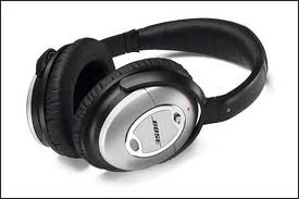
The iPad and iPhone are much more personal devices and do not have the large speakers to share your music with others as the boom box did. Today we see all the kids wearing ear buds or headphones plugged into their iPods or MP3 players. I even have a real nice pair of Bose noise cancelling headphones myself.  These are great for using on the airplane to get rid of background noise and listening to music or movies. Make sure you get the over the ear style shown at right. These are more comfortable and quieter than the on the ear version.

If  you already have an on board stereo system there are a few ways to connect your iPhone or iPad to it.

Most newer stereos come with a 3.5 inch auxiliary connection. You can pick up one of these cables and connect your device directly to your stereo system. 

I prefer to go the wireless route so I am free to move around the boat and also have the ability to change songs and control the volume.  The iPhone and iPad both have Bluetooth technology which is a wireless communications protocol with a range of about 30 feet.

I recently purchased an iHome Bluetooth speaker that works great. It has about a 40 foot range and is rechargeable. It also comes with an iPad stand.


To wirelessly connect my iPhone or iPad to my existing stereo system, I purchased one of these little Bluetooth receivers.  I plugged this into my stereo receiver down below. I am then able to move about the boat with my iPhone or iPad controlling my music selections.  The range is limited but it does allow me to be disconnected. 

Bluetooth can be turned on in your iPhone or iPad in the settings menu under General settings. Once Bluetooth is turned on it will search for your Bluetooth device. You can then pair with that device and connect.


If you have a larger yacht with WiFi on board you may want to use the Apple TV as discussed in my earlier post.  The  Apple TV box will cost your $99 but will give you the ability to stream music or 1080p video to your on board entertainment system and big screen TV.  WiFi will give you extended range and allow you to control your stereo system from anywhere on your yacht.


If you are a gamer there are tons of games for the iPad that will allow you to entertain yourself for hours and hours on those long trans Atlantic crossings.  I am not a big gamer but I have to admit that I have played Angry Bird a few times.

If you are a big reader there are tons of books and magazines available through the iTunes store. Some of my favorites boating magazines are Cruising World, Yachting, Islands Magazine, and Caribbean Travel and Life.


Well, there is no doubt that the iPad is a great entertainment tool to have on board your boat. It is the perfect companion and will keep you entertained for hours. How do you use your iPad for entertainment?

~~~Sail On~~~
Mark