Sunday, December 11, 2016

Signal K and the WihelmSK App

Application: iPad, iPhone Apple Watch, iOS 9.03 or later
Function: Marine Data
Rating: *****
Cost: Signal K free/Open source, WihelmSK $19.99

What the heck is Signal K?

Signal K is new modern open source data format for use with marine electronics. Signal K is based on web communications and display technologies which makes it available to anyone who wants to build systems to use and display marine data. This is truly an open format available for anyone to contribute to and help develop.  A whole new world of possibilities has been made available by converting data from a closed standard proprietary NMEA format to open Signal K standard.

The compatibility of marine electronics was very limited years ago due to the many proprietary protocols of each company. The National Marine Electronics Association (NMEA) 0183 standard was developed in the early 1980s in an effort to provide a standard protocol for marine electronic device communications. NMEA 0183 is a serial protocol that defines how data is transmitted from one device to another. As modern electronics and chart plotters began to develop manufactures realized it had many data and bandwith limitations. The NMEA 0183 was finally updated with the NMEA 2000 protocol in about 2005.

NMEA 2000 had been in development since about 1994. It was developed cooperatively by over 40 manufacturers and organizations including the US Coast Guard.  It was intended to facilitate interconnection and interchangeability of the new digital marine electronics. The NMEA 2000 format allowed for greater bandwith, additional data types, standard connectivity and a faster network style format.  The NMEA 2000 format has worked well and was a much welcome update to the older NMEA 0183 standard.

The creation of the Internet, mobile devices and especially the iPhone in 2007 along with the development of marine apps created the next revolution in the marine industry.  Suddenly the need for this NMEA data had exploded and boaters with mobile devices were hungry for access to it.

The Signal K revolution was started as an open source project by several marine boating enthusiasts back in about 2014 as far as I can tell. The project members develop and supply the software code to anyone wanting to use it or help develop it further.  Signal K received a big boost when Digital Yacht launched a KickStarter project for a Signal K device called iKommunicate. This was well received by the many "early adopter" marine electronic enthusiasts and Digital Yacht has since produced the device for sale. It is available for $299.

The Signal K code can be easily run on a Raspberry Pi server also. The Raspberry Pi 3.0 board can be purchased for about $35 on Amazon. The full installation instructions for the software can be located on the Signal K site. The Raspberry Pi will then wirelessly provide the Signal K marine data to any mobile device over WiFi.

Getting the NMEA 2000 or 0183 data to your Raspberry Pi can be achieved by using a signal converter which plugs into the Pi's USB connection. Actisense is one company that produces these devices. If your onboard instruments are NMEA 2000, the Actisense NGT-1 can connect to your 2000 network and convert the data to USB. A Google search found several companies offering them from $169 to $189. If your marine instruments are the older NMEA 0183, Digital Yacht makes an adapter cable to convert the data to USB for about $55 on Defender.com.

Still in it's infancy, Signal K is starting to receive more support from hardware manufacturers, app developers and programmers.  Apps are now being written to accommodate any data type and display it in digital, analog, line or bar chart display.

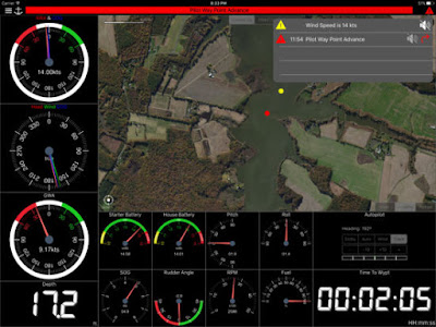
Wilhelm is one new app that was developed by a long time programmer and sailor, Scott Bender. He wanted the flexibility to display marine data the way he wanted on a variety of devices. The $20 app is impressive and has the versatility to display a variety of marine data. The list of feature is extensive as seen below.


Features: 

Supported Connections:
  • Signal K REST api or streaming 
  • iKommunicate REST api or streaming 
Connection Configuration:
  • Apple Watch support 
  • Manual configuration of ip/hostname and port 
  • Signal K discovery via Bonjour 
  • iKommunicate discovery via Bonjour
Raymarine Auto Pilot Support:
  • View or change current mode (Standby, Auto, Wind, Track)
  • View current target heading or Wind direction
  • Change target heading or Wind direction
Alarms and Notifications:
  • View list of current current alarms
  • Acknowledge Raymarine "Turn To Waypoint' 
  • Push notification support 
  • Setup server side alarms 
  • Set an anchor alarm with the push of a button 
Gauges:
  • Raymarine MFD: display and interact with a Raymarine MFD (discovered via Bonjour)
  • Water Temperature
  • AWA
  • AWA and COG
  • AWS
  • Drift
  • Set
  • TWA
  • TWS
  • GWA (Ground wind angle and speed calculated internally from AWS, AWA and COG)
  • GWS
  • Battery Voltage
  • Alternator Voltage
  • RPM
  • Coolant Temperature
  • Oil Pressure
  • Oil Temperature
  • True Heading
  • Magnetic Heading
  • Pitch
  • Roll
  • Yaw
  • SOG
  • COG
  • GPS Position (with link to Apple Maps)
  • XTE
  • Water Speed
  • Distance to Waypoint
  • Route ETA
  • Time to Waypoint (computed internally from DTW and SOG)
  • Depth (adjusted via depth offset)
  • Fuel Tank Level
  • Black Water Tank Level
  • Fresh Water Tank Level
  • Rudder Angle 
  • AWA Close Hauled
  • Engine Run time
  • GNSS Date 
  • GNSS Time
  • GNSS Date/Time
  • Atmospheric Pressure
  • Create a gauge for any value available via Signal K
  • Customize gauge display using Signal K meta.zones
  • Wind Angle gauges can optionally be rotated to the bow, regardless of device positioning
  • Place gauges by long pressing on a gauge and choosing a different one
  • Make a gauge full screen by double tapping
  • Multiple layout support. Create a different layout for Steaming, Sailing, Home Monitoring, etc.
  • Customize the number of pages and layout
  • Manual connection configuration synced across devices via iCloud
  • Automatic connection selection based on current IP (useful when Bonjour is not available and you have multiple boats)
  • Dark and light themes
  • Animated gauge needles
  • iPad Slide over and Split View support (Your gauge configuration can be customized for these views)
  • Connections refreshed manually or at specific intervals
  • Design your own custom gauge templates
  • Share templates via Air Drop, eMail, Text, etc.
  • Edit ApplyTV or other device layouts and templates remotely using your iPhone or iPad
  • Digital or analog gauges
  • Enter the Signal K path and title for any gauge to show data not supported by default

The list of gauges that WilhelmSK supports is impressive. The app has the versatility to display over 40 different parameters and more are being added with each release. The gauges can be displayed in either digital or analog format with light or dark backgrounds.  

The app displays can be customized in several ways by the user which allows development of personalized displays. Several instrument layouts can be developed to include the data in the desired groupings.  You can even develop displays for the Apple Watch.

WilhelmSK Apple Watch
The app should work with any Signal K server. Digital Yacht's iKommunicate device and the low cost Raspberry Pi servers can be configured as well. These devices have to be connected physically with your onboard instrument's NMEA 0183 or 2000 networks. The data is then provided from the server over WiFi to your mobile device. 

Apple Watch support is also provided. How cool would that be to have all your boat's instrument data available on your wrist. Alarms could alert you to problems on board that you might otherwise miss. My mind is just racing at all the possibilities for using this technology.

I applaud the Signal K group and programmers like Scott Bender who are blazing a new trail in the marine data industry. Making data available in a non proprietary open source format sure make sense to me. 

Other app and devices that support Signal K are listed below. I am sure this list of apps and servers will explode within the next year as this new and open source protocol catches on. 
I am excited for the marine industry and the future of Signal K. This effort will allow the average user to create their own displays and better utilize all the marine information for hopefully a safer and more enjoyable boating experience.

So who is ready to buy a Raspberry Pi and get started?

~~~ Sail On ~~~ /)
Mark

Saturday, November 19, 2016

Sony SRS-XB3 Pairable Bluetooth Speakers

I know this is a little different than my usual Marine App post but I thought it might be of interest to some of you. As a sailor I am always looking for technology that will make my boating experience easier and more enjoyable.

Entertainment on your yacht will most likely includes some form of music. Most sound systems on boats are hardwired into the vessel's 12 volt power supply. A set of wires then has to be run to each of the speakers at various points around the boat. This means the installation can be messy and expensive. That is the traditional "old school" way to set up a stereo system on your yacht.

Everyone now carries around a cell phone or mobile device. These phones are little super computers that not only allow us to communicate but to also run a variety of marine app which I have written about in this blog. My phone already has all of my favorite music and some video on it so, why not build an entertainment system around that? I also have a blog for my S2 22 ft sailboat in which I shared my design for the Ultimate On Board Entertainment System. This included the an iPhone, a WiFi router, an AppleTV and some AirPlay speakers.
iHome IW3 AirPlay Speaker

Bluetooth and AirPlay speakers have been around for several years now and I own several of them. They offered an easier mobile solution to my entertainment needs. I liked the idea of not having to drill holes and run wires all over my boat. In my blog post I designed my system around the Apple TV which I converted to 5 or 12 volts to either run off of USB or 12 volt power. I wanted to be able to have more than one speaker so I pursued the use of AirPlay speakers which require that the boat have a WiFi router that both the speakers and my iPhone can connect to. This worked fine and I have been using it for the past few years.

My latest discovery, which you may already know is that the latest version of Bluetooth allows more than on speaker to be connected to each other and then be connected to a device providing a true mobile wireless stereo system.

I researched the latest Bluetooth speakers and found a few that have this capability. Some of these manufacturers are Sony, JBL Flip 3 with JBL connect, Sharkk and Logitech UE Boom and SoundBot Quadio.  Those are a few of the speakers that I found with the capability to be paired together and there may be others.

Sony SRS-XB3 Bluetooth speakers
I chose the Sony SRS-SBX-3 model after some research and watching some YouTube videos. This model has a large rechargeable battery with a long 24 hour run time. The speakers come is several colors and normally run about $149 but I purchased some on Amazon for $98.

Specifications:
  • 2 Channel speakers + passive radiators
  • Extra Bass
  • Audio in jack
  • Bluetooth Version 3.0
  • Remembers 8 paired devices
  • Weight 32.8 oz
  • Compatible sound formats A2DP, AVRCP, HFP and HSP
  • Range 32.8ft
  • Condenser microphone
  • Noise suppression for phone calls
  • Omni directional speaker
  • Li Ion battery, 24 hour battery life
  • AC charger
  • Auto Power off after 15 Min
  • NFC, Android Near Field Communication
  • 20-20,000 frequency response
  • 30 Watts power
  • Dimensions L 8.31 X H 3.15 X W 2.37
  • Audio In jack
  • 5 Volt USB charging outlet
  • Water resistant IPX5 rating
I liked that the speakers were very compact and re-chargeable so I could not only use them inside my boat but I could move them out into the cockpit or take them ashore for a beach party if I wanted.

They are water resistant so a little rain or sea spray will not damage them. Mounting options are limited but I found Velcro works nicely to hold them into place on a bulkhead or shelf.

The speakers have seven button on top of the speaker to control the functionality. These include the Power button, Volume Up and Down, Phone, Add, Pairing and Extra Bass.

The Power Button will power the speaker on and it will also power down the the speaker and the other speaker that it is paired with.  This is convenient not having to go to each speaker and power them down separately.

The volume Up and Down buttons control volume on both the speaker and the other speaker that it is paired with. Volume can also be controlled from your mobile device's volume controls.

The Pairing button is used to connect the speaker to your mobile device and to a second speaker if desired. Make sure to turn on Bluetooth in your mobile device's settings. Press and hold down the pairing button until you hears some beeps which puts the speaker into pairing mode. The pairing indication will flash rapidly white. Go to Bluetooth settings on your device and select SRS-XB3. Once the speaker is paired it will remember your device. The speakers will remember up to 8 devices and automatically pair to your mobile device the next time it is used.

The Add button is used to pair an additional Sony SRS-XB3 speaker to the existing speaker. The speakers have to be paired with each other before they can be paired with your mobile device. First turn on one speaker and hold the Add button down until you hear a tone. Next turn on the other speaker and select the Add button again. This will pair the two speakers together.

Next to the Add button you will see a L and R indication light.  Once the speakers are paired together, tapping the Add button will change between stereo, left and right channels or mono natural. When L is selected on one speaker and R is selected on other this will give you true stereo channel separation for an awesome sound.  Selecting both L and R on each speaker will give you both channels in each speaker. I have not seen many speakers allowing the stereo channel separation option.

Once the two speakers are paired together you can then pair your mobile device to the first speaker that has the pairing indication flashing.

The Extra Bass button provides just that. Pressing this allows each speaker to delivery a richer and deeper bass sound. When the two speakers are paired together pressing this on one speaker enables it on both speakers.

On the back of the speaker behind a pop off door are the connections for the DC in for charging the speaker, USB DC out for charging a mobile device, audio in jack and a reset button.  The USB DC charging feature is another option that could come in handy if your mobile device needs charging.

I am sure there are other more expensive Bluetooth options out there for mobile speakers but for $98 on Amazon, these little speakers are an awesome set with many capabilities.

What are you using on board your boat for speakers and entertainment systems? Please comment below and let me know what is working for you.

~~~~ Sail On ~~~~/)
Mark

Saturday, September 24, 2016

FLIR One for iOS and Android

Application: iPhone, iPad, iOS>7.0, Android devices
Function: Thermal Imaging, night vision
Rating: *****
Cost: FLIR One $249, Apps are Free

All images compliments of FLIR
The iOS and Android mobile devices are impacting every industry on the planet. These small computers and apps that we carry around in our hands can do some pretty amazing things. My blog is primarily focused on marine charting, weather and navigation apps. The application of a thermal imaging device is a bit of a sidebar but I thought it was interesting, useful and very applicable to the marine industry.

The digital imaging capabilities of the iPhone make it perfect for a thermal imaging device. FLIR is one of the leading thermal imaging companies in the world.  FLIR makes commercial imaging cameras and devices for a variety of uses including night vision, fire fighting, law enforcement, security and surveillance, safety, electrical maintenance, search and rescue, marine, energy efficiency.

I reviewed the iPhone 5/5s FLIR One thermal imaging device in a blog post back in 2014. That device retailed for $349 and was more of a case version that the iPhone fit into. Rather than trying to keep up with the ever changing sizes of each iPhone release, FLIR created a more universal device which connects through the lightning charging port on the bottom of the iPhone or iPad. There is an Android version also.

Their latest addition to their product line is the FLIR One compact dongle that can be attached to your iPhone or iPad which allows you to see the infrared spectrum on your devices display. The Android version connect to the micro USB of that device.

The FLIR ONE dongle uses MSX technology which utilizes two cameras to scan images. One camera picks up the thermal imaging spectrum and the other picks up a visual image. The two images are combined to create a unique viewable image.

Features:
  • Measures temperature from -4 degrees F to 248 degrees F(-20 C to 120 C)
  • FLIR MSX technology
  • Lepton imaging technology
  • Attaches to iOS devices through the lightning connection
  • Attaches to Android devices through the micro USB port
  • Capture still or video images .mov
  • Panorama
  • Time lapse
  • Close up
  • 7 Dynamic video display palettes, rainbow, BW, WB, rainbow, contrast, arctic, hot and cold and iron
  • Social media sharing Twitter, Facebook, Instagram, email and text
  • Internal re-chargable 350 mAh battery
  • Battery monitor
  • Copy image to camera roll
  • Detects temperature differences of about one-tenth of a Fahrenheit degree, and the temperature readout is accurate to within 2 degrees
  • Observe heat sources, heat differences, fire, overheating equipment or components
  • See through smoke and haze
  • Detect insulation leaks and energy efficiency problems
  • Aid in man overboard nigh time situations 
  • One year warranty
Boat Beacon Man overboard
There are several apps that can be used to display the thermal images. The popular Boat Beacon app has incorporated the use of the FLIR One into its augmented reality display. Other iOS apps can be found in the App Store such as Thermal Compare and the FLIR One Paint app.  Check out FLIR's list of all compatible apps for the FLIR One.

This device can be used for many applications around your home or on you boat. I can think of many uses including checking engine temperature, exhaust or hot spots, checking insulation around windows and refrigerator seals. This app could help you see hot spots and locate faulty wiring connections.
Boat Beacon Augmented reality night vision
On a boat it might be useful in a man overboard situation. This thermal imaging device could help you locate a person by their thermal signature on a pitch black night.

There are marine apps that have incorporated this functionality into their displays. The image from Pocket Mariner's Boat Beacon app shows what their augmented reality app display looks like. This night vision display make it easy to pick out other boats and ships in the area. Pocket Mariner has a blog post about the use of augmented reality night vision display using the Flir One dongle attached to an iPhone.

I am a real gadget guy and think it would be cool to have one but would this really be something I would use on a daily basis. I am still on the fence. The price of $249 makes it a little more attractive.

I would be interested to hear from anyone who may have this device or a night vision scope. Do you find these devices handy or are they just an expensive piece of gear one could live without?

~~~ Sail On ~~~ /)
Mark


Saturday, May 28, 2016

Airmar OnSiteWX Weather and Instrument Display

Application: iPhone, iPad, iPod Touch, iOS 6 or greater
Function: Weather and Boat Instrument data display
Rating: *****
Cost: Free


Instrument data is more prevalent than ever on modern cruising yachts. Having easy access to this data can be very useful for monitoring your yachts engine performance and function.

Sailors will be interested in instrument data like Speed, COG, Wind speed and Direction. The ever popular Depth indication is needed on all yachts. Most of these can be viewed from the helm station or at the chart table if you have instrument repeaters.

Having all of your instrument data broadcast over WiFi makes it available to mobile devices like tablets or mobile phones wherever you are on the boat.

There are many NMEA to WiFi devices that can be connected to your navigation systems to broadcast the data over WiFi. I have written about many of these apps over the years on this blog.  I have a list of my top 10 instrument data apps shown here. I think this app may be worthy to make the list.

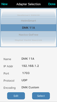
I recently acquired a DMK Marine 11a module for my yacht.
This device has the option of connecting to NMEA 0183, NMEA 2000 or Raymarine SeaTalk instruments and broadcasting this data over WiFi.  The versatility of this unit is the reason I selected it.

MillPort Media has developed an app called OneSiteWx to display all kinds of weather and NMEA 0183 and 2000 data. It is compatible with all the Airmar weather station products so it can provide all the weather data directly to your mobile device.

The app is unique in that it can provide weather data but also can display any of your boats NMEA 2000 or 0183 data.The app is available from the AppStore from here.

There are several pages of instruments already developed for the most popular readings you will need.  Custom pages can also be created with 1, 2, 3 or 4 instruments per page so you can group the instruments as needed.

Features:

  • Custom pages
  • Air temp Celsius or Farenheight
  • Air pressure
  • Wind speed and direction, true and apparent
  • Water depth and temperature
  • System time and date
  • GPS position
  • COG/True or Magnetic
  • Heading True or Magnetic
  • Pitch and roll
  • Page selection
  • Black and white gauge display
  • Digital or analog gauge display
  • US or Metric units
  • Tachometer
  • Speedomenter
  • WiFi capable
  • NMEA 2000 and 0183
  • Compitable with SeaSmart SSN2K, HelmSmart, DMK 11a, Navico GoFree, Digital Yacht NavLink, WLN10, Miniplex 2Wi, Vesper Marine and MailaSail Redbox.
  • Optional dual engine speed fuel tank gauges available with an in app purchase.
The beauty of this OnSiteWX app is that you can use the standard pages to display data and you can also create custom pages of any grouping of instruments that you want.

Select the green MENU button on the upper right of the app display. The Menu page contains the options to display some Demo data on the displays, Select Display Preferences, Manage pages, Create custom pages and more.

Select Create Custom Pages to develop your own pages for the data you want to display. A screen with four selections will come up. Select the number of instruments per page. Simply hold your finger down on the instrument and a menu of instrument types will come up.

Select the instrument type for each of the custom instrument displays on your page. 

There are 60 different types of instrument to select from.  The custom display can then be save or renamed for your reference. 

The Adapter Selection provides a list of the many WiFi devices that the app is compatible with. The adapter is the device that provides your yachts weather and marine data over WiFi. If your WiFi device is not listed select the NEW button on the top to create the IP address, port and protocol settings for your device.

I am impressed with the OnSiteWX app not only for the ability to display all the weather data I need but that it also can display all of my instrument data from my yacht. Having all of this data in one app makes it more convenient and easily accessible. This means I don't have to jump between several apps the get the data I need.  

The apps is free so you can't complain about the price. It is definitely worth picking up and giving it a try.

~~~ Sail On ~~~ /)
Mark

Sunday, April 17, 2016

Weather4D 2.0

Application: iPhone, iPad, iOS7, iOS9 and Android 4.2
Function: Marine Weather Forecasting and Route planning
Rating:*****
Price: $49.99

Weather4D 2.0 is one of those apps that has become a big game changer in the area of marine weather and routing. I originally reviewed Weather4D back in 2011 and was impressed with the new and unique way weather information was presented in the app.

APP4NAV LLC has continued to add features and functionality to the app to keep me coming back. I have reviewed many weather apps over the years and this one ranks near the top as one of my favorites.

As a boater you all know weather can either make or break your day on the water. It pays to know what your up against when heading out for the day. If your a geek like me you will appreciate the versatility of the this app. The app has several versions both for iOS and Android devices. The table below shows the features with each version.


Marine  Charts:

The app can display a variety of charts. Raster charts can be downloaded from the chart server at Geogarage. The following countries are supported. 
  • USA NOAA Raster charts
  • Canada CHS
  • Bahamas WLP
  • Brazil DHN
  • Argentina SHN
  • France SHOM
  • Polynesia TOM
  • United Kingdom UKHO
  • Germany GSH
  • Netherlands NLHO
  • Australia AHS
  • New Zealand LINZ
Features:


  • Multiple Weather models
  • Apple Watch support
  • Cloud cover
  • Precipitation, rain and snow
  • Wind 10M above sea level
  • Temperatures 2 M above sea level
  • Barometric pressure
  • CAPE
  • Wave heights, period, direction
  • Currents speed and direction
  • World maps Bing and OSM
  • Weather 4D 2.0 comes with free GFS .025, .5 and 1 degree models
  • Data model include NOAA GFS, NAM, CMC, GEM, WRF, FNMOC WW3, MyOcean and Tidtech, Arpege and Arome French, Aroma HD models with in app purchases
  • 1 Year HD Forecasts subscription $33.99
  • 10 day forecasts
  • 3, 12 and 24 hr data
  • Worldwide coverage
  • Resolution to .025, .1,.25, .5, 1 and 2 degrees
  • Data updated every 6 hours 4 times a day.
  • Isochonuos routing for motor or sail
  • Import KMP and GPX files
  • Iridium satellite prediction paths
  • Satellite download of weather data
  • Import GRIB type 1 files from email, SailDocs and Safari
  • "Open In" feature for file imports
  • Routing with Polar diagrams
  • AIS by Internet through AIS Hub displayed in Blue
  • NMEA WiFi support
  • NMEA AIS targets displayed in Green
  • Navigation displays SOG, COG and distance of route legs


  • Navigation:

    Weather4D 2.0 is much more than a weather app. It can provide weather and routing data on marine charts from a variety of hydrographic services in many countries.

    The navigation features include recording waypoints, simulating routes, displaying latitude, longitude, GRIB data and weather overlays.  

    The navigation mode also displays instruments that provide real time data. The instruments include SOG, COG, VMC, DTW, BTW and ETA. Data can be received from an external WiFi connection and can include AIS data through a NMEA TCP/IP connection. So you can display all your onboard instruments within the app. Your boat instruments will need to be connected to an onboard WiFi router.

    Routes can be downloaded from navigation apps like iNavX to be displayed in Weather4D 2.0. 

    Routing:


    Weather4D has a very powerful weather routing feature integrated into the app. Polar diagrams for your sailboat can be programmed into the app so it can predict the best route for your vessel. 

    The GRIB weather data must then be downloaded for the duration of your passage. A route with waypoints then needs to be downloaded in GPX or KML format from a navigation app such as iNavX.


    Once Weather4D knows the route it overlays the weather and calculates the best possible route for your vessel taking into account the latest weather information.  Very few apps are able to do these very sophisticated calculations.

    Several cruisers that I follow on YouTube have had great success with the app and another similar app called Predict Wind.  Make sure to check both of these out to see which one works better for you.

    These apps don't come cheap but they may be a better value than hiring a weather routing agency to do the work for you. The Weather4D app cost $49.99 and if you want the additional forecast models those will run another $33.99 for a years subscription.

    If your crossing oceans and making long passages Weather4D may be for you. It can provide all the weather data you will ever need and give you confidence with routing for the conditions you will experience on your passage. Add in the ability to download weather data from a satellite connection and you have the total package. 

    I would like to hear if anyone has had experience using Weather4D. Francis Fustier has an apps blog site named Navigation Mac. He has worked extensively with the authors of Weather4D and has developed a users guide outlining all the features of the app. You can access all of these Weather4D reviews and tutorials on his website. 

    ~~~ Sail On ~~~ /)
    Mark


    Saturday, February 20, 2016

    ActiveCaptain and Jeppesen Charts - "Marriage Made in Heaven"


    Last week Jeppesen announced that it will be integrating the ActiveCaptain data into their popular C-Map chart products. The Active Captain data was introduced on the C-Map charts at the Miami International Boat show and will soon be available on their chart products this spring.

    I have reviewed all the ActiveCaptain products over the years including the Location, Drag Queen and the Companion apps.  I have been a big supporter of the crowd sourced POI and other data available through their website and the many apps that also provide the data. ActiveCaptain is the world leader in providing a unique set of verified crowd sourced marine data which has made the yachting experience safer and more enjoyable.
    ActiveCaptain in iOS app SEAiq
    ActiveCaptain and their legion of users provide detailed information about marinas, yacht clubs, marine fuel, docks, marine services, anchorages, marina reviews, hazards, shoals, currents, navaids, markers, bridges, locks, dams, ferries, boat ramps and marine stores.

    ActiveCaptain has users world wide but the majority of them are located in the United States and cover areas including the east and west coasts, Florida, the Intercoastal waterway, Great Lakes and San Juan Islands.

    Jeppesen will include this data in their March release of their C-Map 4D, Max and MaxN+ electronic charting products. These charts are used by many of the leading chart plotter manufacturers including B&G, Simrad, Lowrance, Furuno and Raymarine. This will bring the ActiveCaptain data to millions of new users all over the world.

    ActiveCaptain  C-Map on Furuno NavNet
    The C-Map charts will have the latest ActiveCaptain data at the time they are published. Subsequent updated data will be added to new C-Map chart releases.

    The ActiveCaptain data in the C-Map chart sets will be static because it will resides in the chart plotter memory. Dynamic updates will not be available like the data in many of the popular mobile device apps using ActiveCaptain. These apps are updated with the latest data from the ActiveCaptain database.

    Much of the data about marinas, marine stores, services and bridge heights does not change that often so it is mainly the reviews, hazards and fuel prices that won't be up to date.

    The ActiveCaptain data can only be updated when you update your charts on your chart plotter. This is slight draw back so it is recommended that you get more frequent updates to your charts to have access to the latest data. At some point in the future I could see all chartplotters being tied to the Internet and being able to keep the database up to date.

    Congratulations go out to the Active Captain crew and Jeppesen for creating this unique relationship. The addition of the ActiveCaptain data to the C-Map charts allow access to this enormous database to millions of new users.  Consider using the new C-Map charts on your chartplotter!

    ~~~ Sail On ~~~ /)
    Mark


    Monday, February 15, 2016

    Dockwa - Reserve a Slip or Mooring!

    Application: iPhone, iPad, iPod Touch, Android
    Function: Marina slip and mooring reservation app
    Rating: *****
    Cost: Free

    There's an app for that! Have you ever wanted to be able to reserve a slip or mooring in a marina before you left or while you were on your way to your destination? Well, you are not alone. Why can't reserving a slip be just as easy as making a hotel reservation? The smart guys at Dockwa have solved that problem with their new website and app. The Dockwa app is available in iOS and Android versions so is will work on all your mobile devices.

    Dockwa was launched in May of 2015 by CEO and founder Mike Melillo. In October they were recognized by BoatUS and formed a partnership to provide discounts to Dockwa users at BoatUS participating marinas.

    In the past, many of us have had to deal with the stress of not knowing if we had a slip or not. The process often involved trying to locate a marina and phone number or trying to arrive early before the slips of our favorite marina filled up.

    The Dockwa app was developed to take the worry out of where you are going to spend the night. The Dockwa app and website are laid out by region with many details and colorful pictures of marina destinations.

    The app is easily navigated with an on screen menu. Five soft keys across the bottom of the home screen are used for navigating within the app. The Search option is the first  key on the bottom left.  Simply page through destinations or type a location in the search box at the top to locate marinas in that area.

    The next icon is the Map selection which shows locations throughout the United States with red markers. The east coasts is very well represented with many locations marked along the inter-coastal waterway.

    The Florida gulf coast also has several locations fairly well covered.  Other than that, a few other marinas are shown in the Great Lakes and the Pacific northwest. Future expansion plans include the Great Lakes, west coast and the Bahamas.

    The Map page allows you to apply filters by tapping the blue bar at the top. Filters include arrival and departure date, type of dockage, services and amenities and Boat US discounts. Applying the filters will then show you the marina locations with your filtered selections.

    The next soft key is the Calendar icon. This page will show you all your reservations that you have made. This will require you to log in to your account.

    The next selection is the Message Center. This will be used for communications between yourself and the marinas where you have reservations. If something comes up or your going to be late simply sent the marina a short text to notify them of your plans.

    The last icon is the Profile page.  Here you can sign up or log in into your account. In your account data you can provide a method of payment so there is not need to enter your card information each time. The marinas can automatically bill you for all the services during your stay.

    Features:


    • Review and book with marinas right from you mobile device
    • Book from hundreds of marinas and yacht clubs up and down the East Coast and Caribbean. 
    • Expanding to the Great Lakes and West Coast in 2016!
    • No booking fees to reserve a marina. 
    • Request a dock or mooring using the app and get confirmation within minutes. 
    • On-demand service means no long waits and more trips!
    • Book same day, nightly, or multi-day trips in advance or last minute. 
    • Accommodates all types of reservation requests.
    • Compare rates, amenities, and services for different marinas and provides quotes in the app.
    • Add your boat and credit card information to your secure account profile so you never need cash on hand at the marina.
    • Select your check-in and check-out times, berth type and electric requirements for your vessel.
    • Marinas, Yacht Clubs and Boatyards can benefit from enabling reservations automatically.
    • Enable marina customers to reserve transient slips and moorings without the overhead of manually dealing with reservations over the phone.
    • Back-end marina management software is provided to marinas at no cost.

    There are other similar apps out there that provide marina information. ActiveCaptain is by far the leader in providing marina information and reviews for thousands of locations around the world.  The ActiveCaptain website and apps display crowd sourced POI and marina information, reviews, services, fuel prices and more. Dockwa has no where near the coverage but they have gone one step further and provided the marina reservation and billing through e-commerce.  This app is a win-win for both the boater and the marina operator. Boaters now can easily make reservations and pay for marina services easily with mobile devices. Dockwa has also helped marina owners with marketing and has streamline the reservation and billing process.

    Dockwa has found a niche and will be expanding throughout the United States and abroad in the near future. I would think once they get their marina locations built out they could easily add a Trip Advisor type review system to thir site also.

    Has anyone used Dockwa? What was your experience?

    ~~~ Sail On! ~~~~/)
    Mark

    Sunday, January 17, 2016

    Smart Chart AIS

    Application: iPhone, iPad, iPod Touch, Android phones an tablets
    Function: Marine Charting, AIS and Points of Interests
    Rating: *****
    Cost: Free

    The Smart Chart app has been around for a while but has been recently upgraded to the Smart Chart AIS app in the App Store. The addition of some exciting new features make it worth taking another look.

    Features:
    • Free NOAA Raster charts of the United States
    • Puerto Rico and the USVI charts included
    • Satellite map views
    • Internet based AIS A and B targets
    • Nexrad Radar
    • Active Captain Points of Interest marinas, services, reviews, ratings and anchorages.
    • Augmented Reality Display
    • Chat Feature
    • Center on location
    • Picture and Video Mode selection
    Registering:

    Once you download and open the app you will notice that you will need a user name and password. This is easy and free to register.

    Once logged you will need to select a vessel. You can select a trial vessel until you get yours set up. The Smart Chart AIS website also has resources and tutorials about the app.

    The app's main screen has a world map and if you view the United States you will see colored boxes on the display. As you zoom in the chart data will fill in automatically.

    It does not appear that the charts are downloaded for offline use. If you zoom into the same area later on it appears the charts have to be downloaded again.

    I turned WiFi and may cell service off and sure enough, no chart data displayed.

    The Active Captain points even disappeared which is confusing because that database should reside on the device itself and be available for offline use. 


    Charts:

    The app uses the NOAA digital ENC charts for navigation purposes.  These charts covers just the continental US coastal waters, the Great Lakes, Hawaii, Alaska, Puerto Rico and the Virgin Islands.  These charts provide detailed soundings, channel markers and lights. The charts automatically download as you zoom into a particular area. 

    I found that there was a slight delay as the charts were downloaded and displayed.  Perhaps that was my slow cell or WiFi connection.  The charts do not appear to be saved on the device which is a bummer because that means the charts will not display if I am out of cell range.

    Most apps download the charts to the device so they can be used offline away from WiFi and cell coverage. 

    Navigation:

    There are six soft key icons across the bottom of the main display for app navigation. The latitude and longitude are also displayed just above the navigation icons. If your position in displayed in red that means the accuracy is reduced. If it is displayed in green, you are good to go.  

    The far left icon that looks like a bullseye, is for centering the display and chart on your present location. The next icon to the right is for adding and deleting points of interest. The Delete all POIs selection will remove any POIs that you add manually.  To add a POI, select POI icon and then the Points of Interest tab.  Tapping on the chart adds a pin to mark your own POI.  

    The next icon is the Chat icon. Selecting this bring you to the chat page. Mine was empty and the only selection at the bottom right was New Chat. I selected that and it gave me a No Users to Select error. Evidently there are no Smart Chart AIS user in my area or within range of the display. Once a user is selected you can then start a chat conversation.

    The next selection to the right is the Camera icon.  This is a quick way to start your devices camera or video without having to leave the app.

    The next icon labeled AR is the augmented reality display which will superimpose important information onto a real time image. The AR selection is only visible if your device has an accurate GPS location.

    The app accesses the devices rear facing camera and overlays buoys, markers, points of interest and other users on the real time camera display.

    Active Captain POIs are also displayed on the AR screen. Click on these points for more detailed information. The devices compass direction is shown at the top for added navigation. I works much like a hand bearing compass.

    Active Captain POI:

    The last icon on the far bottom right accesses the settings of the app. Settings include logging into your Active Captain account and selecting map layers.

    Map layers include the NOAA ENC charts, NEXRAD visible radar, Smart Chart and AIS displays.

    To display the Active Captain POI's you will need to log in to your Active Captain account. If you don't have one, go to the Active Captain website and sign up for free.

    Active Captain provides crowd sourced information on markers, marinas, anchorages, local knowledge, and hazards. These are all color coded for easily identifying them on the map.

    All pertinent marinas in the area are marked by red icons, anchorages are shown with green icons, local knowledge are shown with blue icons and hazards are shown with yellow icons.

    Click on any of these to access a wealth of knowledge from the Active Captain database.  This data resides on your device so you should be able to use it offline away from cell or WiFi service.


    AIS:

    AIS stands for Automatic Identification System.  The actual commercial Class A and non commercial Class B systems are broadcast and received over marine VHF frequencies.

    The Smart Chart app utilizes land based AIS receivers that rebroadcast this data over Internet connections to your device. So this feature will only work if you have an Internet connection.

    The purple triangular icons are ships that have AIS transmitters. Tapping on the ships icon will bring up the name and location of the vessel.

    Tapping on the info box then brings up additional information about the ship. This data can be use for collision avoidance and closest point of approach calculations.

    Well, final thoughts about the Smart Chart AIS app are that it does the functions it provides fairly well. To be honest, It would not be my go to app and I would probably not use it myself.

    If your looking for a basic app with charts, some navigation, POI and AIS features it may work for you. It is free and available for both Android and iOS devices.

    ~~~ Sail On ~~~ /)
    Mark