Sunday, October 30, 2011

Jeppesen Marine Plan2Nav

Application: iPad1&2 and iPhone 3GS, 4
Function: Marine navigation, planning and charting
Rating: ****
Cost: App is free, charts purchased in the app

Jeppesen navigation has been around for years providing aviation and marine navigation and charting systems. They are a Boeing company, perhaps you have heard of them. Their C-Map products have been a industry standard for years. The Plan2Nav app is their latest marine planning and charting app.  The app is free to download and comes with a worldwide base map for planning purposes. Additional charts can be purchased within the app.

The app was just updated on October 19, 2011 to version 1.0.3.

Features:
  • View charts in perspective mode
  • Enable the GPS to view
    • Speed Over Ground (SOG)
    • Course Over Ground (COG)
    • Estimated Time of Arrival (ETA)
    • Time To Go (TTG)
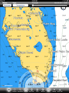
  • Download the free weather and see a five-day forecast overlaid on the chart
  • North-up, Course-up: fully rotating visualization
  • Distance Unit, Clock and Compass
  • NavAids
  • Detailed harbor charts
  • C-Marina port database
  • Dynamic tides and currents
  • Photos and diagrams
  • Depth and land elevations
  • All downloaded charts stay recorded on your iPad and are accessible even when a wireless connection is not available.
The base map shows major land formations and depths. The handy compass at the bottom of the screen shows heading, speed over ground and course over ground.

The rest of the app features are accessed on the bottom of the screen with the soft keys. Realtime GPS, Compass, Search/go to, CWeather, Buy charts, Track, Measure, Route, Settings and Anchor drift.

Weather can be downloaded and includes temperature, humidity, wind and waves. A handy slider at the top shows forecast weather data out five days.

Screen orientation can be changed using multi-touch commands. The view of the charts can be changed to show other orientations.

The compass soft key brings up a navigation display which shows the GPS status, SOG, COG, Latitude and longitude and a dynamic compass.

Plan2Nav has a nice professional look an feel to it. It has many features that are required for marine navigation. The charts are very detailed and allow the user access to the data needed to be confident while navigating.

I found it very intuitive to use and was able to download weather, navigate in realtime, make measurements, create tracks, and routes without to much effort.

I am so impressed with the app that I am moving it into the number 3 spot of my Top 10 Best Marine Charting Apps.

Additional charts can be purchased in the chart store. Both lakes and marine shoreline charts can be downloaded by using in app purchases. Charts prices vary depending on the area and selection.

Additional features include a tracking feature which will track your boats course. A measuring feature allows you to measure distances on the chart for planning or on the go navigation.

Routes can be created by simply tapping and holding a point on the map.  Points are marked and displayed with pins.

Settings allow you to change between different units of depth, distance coordinates, speed, temperature and fuel consumption.

If nothing else download the free Plan2Nav app and take it for a test drive. I think you will find the Jeppesen has a winner here.  The next step is to download a detailed map of your region and explore the rich detail, photos, charts, tides and information available.

Sunday, October 23, 2011

Sailing, Boating and Travel Magazine Apps

Application: iPad
Function: Boating and Travel Magazines
Rating: ****
Cost: Apps are free, subscriptions are $1.99 per issue up to $24.00 per year.


When I am not sailing or working on the boat I like to read about new and exotic destinations that I might want to visit.  I have subscribed to numerous magazines over the years and have stacks of old issues laying around the house and in my closets. With the wide acceptance of the iPad, magazine companies are now making their issues available on this device. The prices for the i-issues range from $1.99 per month to $24.00 per year. 

This is a bargain compare to most paper issues that range from $5.00 to $7.00 per issue. Since we are all trying to "go green", what better way to save a tree than purchase electronic versions for your iPad.  

Some of my favorites are Cruising World, Boating Magazine, Yachting MagazineIslands Magazine, and Caribbean Travel and Life.  These are all available in the iTunes Store.  The apps are free and the in-app purchases of the issues are available.  Download one and give it a try. You can always have your favorite magazine with you when you travel or need something to read while your relaxing on the beach.

The magazine apps have a Store section and a My Issues section.  The store section allows you to purchase and download single issues or purchase an annual subscription. The settings allow you to manage your subscriptions and downloads.

Apples iOS 5 has a new app called Newstand. Many magazines are also available there.

The magazine apps I listed here are not available in Newstand so make sure to search the AppStore for your favorites.

In these apps you will find several features:
• A free sample issue
• The ability to buy a single issue or subscribe monthly or annually.
• New high resolution image featuring pinch & zoom
• Social sharing
• Complete cover-to-cover issue (including all ads)

You may purchase subscriptions for these magazines through what they call an in-app purchase. Payment will be charged to your iTunes Account at confirmation of purchase.

With the convenient access and ability to purchase your favorite magazines anytime anywhere, it couldn't be easier.

Download your favorite and start dreaming and planning for your next exotic destination.

Sunday, October 16, 2011

Hurricane HD 2.1

Application: iPad versions available for iPhone
Function: Weather, hurricane tracking
Rating: ***
Cost: $3.99


Each year from June to November sailor in the lower latitudes keep their eyes on the skies. The hurricane season for 2011 has been fairly quiet along the gulf coast.  Several remnants of hurricanes have caused severe flooding in the northeast. September is historically the busiest month for hurricanes but for those sailors in the Gulf of Mexico and Caribbean it is far from over. 

The hard working people at Kitty Code have developed Hurricane HD to keep you abreast of the latest tropical storms and hurricanes. This is an iPad app to give you the best view of the approaching hurricane systems.

Features:
  • World Wide Interactive Tracking Map with storm data, generated on your device as it becomes available, throughout the hurricane season.
  • The newly updated tracking map now allows for the display of multiple tropical systems simultaneously, while the Hurricane HD Historic Storm Library gives you access to memorable storms of the past and can be displayed along side current storms within the tracking map.
  • With the new Storm Center, active storm bulletins, forecasts, satellites and radar are all at your finger tips, along with the ability to play through storm tracks
  • Use the Historic Storm Library to learn more about past hurricanes like Camile, Hugo, Andrew and Katrina, just to name a few. All hurricanes back to 1851 in the Atlantic, and 1949 in the Pacific are available!
  • Internet Connection required to receive new plots and view new satellite pages and text bulletins.
  • Tropical Outlooks, Discussions and Summaries produced by the National Hurricane Center (NHC), Central Pacific Hurricane Center (CPHC) and the Joint Typhoon Warning Center (JTWC)
  • Each ACTIVE storm has:
  • Storm Centered Satellite Images
  • Forecast Image Maps
  • Tropical Bulletins from the NHC, CPHC and JTWC:
    • Storm Bulletin
    • Storm Forecast/Advisory
    • Storm Discussion


  • Storm Probabilities (NHC/CPHC)
  • Radar (when available/within radar range)
  • Satellites which contains Generic satellite images and satellite loops
  • All Satellite views updated throughout the hurricane season, and updated to current imagery as they become available.
Hurricane HD is one of many hurricane apps available but is unique in that it has the ability to track all storms on the go. Check in real time with the animated satellite images, tracking maps and interactive forecast.  The additional narrative bulletins provide detailed information.

The app tracks all tropical storms from both the Central Pacific Hurricane Center and National Hurricane Center. The app not only provides data about active storms but also give you data about inactive storms from past seasons.  

For $3.99 this is a great app for keeping track of these monster storms. Don't get caught on the high seas without Hurricanes HD.

Sunday, October 9, 2011

Navtech iPlotter Solent HD

Application: iPad, iPhone, iPod Touch
Function: Marine passage planner and charting
Rating:***
Cost: $7.99

Navtech has put together a nice app for passage planning and viewing those routes on maps. The passage planner uses a Solent marker and buoy database. Waypoints are selected from the database to built a route. Stream direction and flow can be input to calculate the course to steer.

The app has two main sections. The first is the Passage Planner which allows the user to create routes using waypoints and sectors. Waypoints can be added to the database manually by tapping and holding your finger on the map.

The second section is the Map-Nav section which allows the viewing of the routes and realtime tracking.

Features:
  • Passage planning using a database of markers and buoys.
  • Solent marker and buoy database.
  • Calculation of of course using tidal stream flow and direction
  • Simulator mode to play route.
  • Nav mode to show vectored display of the passage plan and waypoints
  • Map mode displays the passage plan and waypoints overlayed on a map.
  • Internet connection required for display of maps.
  • The GPS mode allows real time updates of boat position on the map. Device must have GPS capability

This display allows the user to select different markers and buoys to build a passage. The course, heading, distance and time are displayed for each section of the passage.


Sectors can be edited by changing the direction and speed of the tidal stream.


In the Nav mode you can view the passage route along with estimated time (ETE), Distance (DTK), Crosstrack Error (XTE) and Speed Over Ground (SOG)


In Simulator mode you can run the route and view a simulated boat as it traverses the route.


The map view can be changed between locator modes of simulator or GPS navigation mode.

The Map mode allows displays of standard map, satellite and hybrid maps.


I thinks this app would be useful for planning but there are other real time marine charting apps that do a better job of the real time tracking.  It would be nice to have nautical charts instead of the basic maps used by iPlotter.  The maps are only available if the device is connected to the Internet.  Offline use of the maps would be more useful when an Internet connection is not available.

The price point of the app is $7.99. This is reasonable but there are many other apps at that price point that have nautical charts and routing capability. See the rest of my blog for other options. See you on the water!