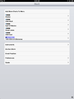
 The most popular post on my blog last year was, iNavX. It was the most searched for and read post during 2011. It is not hard to figure out why, iNavX was one of the first marine navigation apps out there for the iPhone and the iPad.
 iNavX continues to to update the app and make needed improvements to take advantage of all the iPad's capabilities. I plan on writing a series of articles in the next few weeks to showcase this great app. I originally wrote a iNavX post over a year ago and much has changed with the app since then.
Some may shy away from the app because it will cost you $49.99. Don't let that stop you from buying it if you are a serious marine navigation nut like me. It is much more than just a charting app as we will find out. Some other added features you won't find in other apps are AIS, NMEA 0183 and 2000 data, anchor alarm and auto pilot control.
Lets re-visit some of the features of this great app:
- All NOAA RNC marine charts free to download.
- Large chart store X-Traverse with a variety of charts. Charts include CHS Canada charts, Navionics Gold charts, Fish'N'Chip charts, HotMaps, NV. Verlag charts, Hilton's Fishing charts, TRAK Canada lakes fishing maps and Solteknik European waters charts.
- Map and satellite overlays.
- Full line of instruments to display in digital or analog style.
- Instruments types for location services, NMEA 0183 and NMEA 2000.
- WiFi capabilities receive and send data over TCP/IP.
- Ability to email position.
- Create waypoints and routes. Import and export waypoints and routes including KML (Google Earth) and GPX formats.
- Export tracks to email or Facebook via X-traverse account.
- Track Log recording.
- Ability to measure bearing and distance.
- Weather forecast Grib files and tides.
- On screen compass and instrument bar.
- Multi-touch gesture controls of screens.
Let get started using this great app.
1. First download the app from the iTunes Store. You will need an iTunes account to make the purchase. I would suggest downloading it to your iPad if you have one. The larger form factor of the iPad is great for viewing the charts. The iNavX app will work on the iPad, iPhone or iPod Touch with iOS 4.2 or later.
2. Downloading Charts is fairly easy. iNavX allows you access to all the NOAA RNC charts for free. These are the most common charts used for coastal navigation. To download charts select a Chart Region to download. The NOAA charts for Alaska, USA West, Gulf of Mexico, Great Lakes and USA East are available.
This is the NOAA USA East chart list. Simply select one of the charts that you wish to download. You will then be asked to download the chart or download all "USA East".
If you want all the charts, go for the download all. If you are just interested in the one chart you selected, select "Yes".
The charts that you have downloaded will now show up in bold.
There are three indications at the top of the chart display.
There are three indications at the top of the chart display.
 The magnifying glass will allow you to search by number or name. The Triangle will show charts that intersect with your position. The Clock will show you the most recently opened charts.
If you want additional charts other than the free NOAA charts you can purchase these through X-Traverse. This process is complicated, so follow below.
You will need an X-Traverse account to purchase and access your charts. This account will cost you $10.00 per year and allows you access to your charts through the iNavX app. Access to Grib weather files and transfer of waypoints and tracks can also be done through your account.
 Once you have your X-Traverse account you can then purchase additional charts. Make sure you purchase the iPad charts for download. They offer a wide range of Navionics, CHS Canadian Charts, Fish"N"Chips, HotMaps, NV Verlag and Hilton fishing charts.
To access and download your purchased charts in your iNavX app you need to add your X-Traverse account information to the app. Go to "Preferences" and select "X-Traverse Account". This is where you will add your email and password for your account.
Next select "Show Account Information" this will retrieve your account info showing you what products you have activated for use by the iNavX app.
You will next need to go back to the Charts list and select "Add More Charts to Menu". The next menu should show you the list of charts. The charts you purchased should show up as bolded. I purchased Navionics Gold Marine Charts 2011. Select this and another display will show the charts in that package. Turn "ON" the charts you purchased.
Go back to the iNavX menu and select the chart you turned on to view you charts. Select your chart title and download you your iPad.
My next post will cover the charts display and navigation screen features for iNavX.


