Saturday, June 18, 2011

iNautical

Application: iPhone, iPad, iPod Touch
Function: Chart viewer
Cost: Free app, charts $15.99
Rating: *

Waterproof Charts LLC has been around the marine industry since 1984.  They are well known for their high quality paper marine charts.  They were the first company to repackage the NOAA charts and provide them on a waterproof and tear resistant paper.  Now they are providing these same charts electronically.  Their new app, iNautical was just released June 17, 2011 and provides access to these same great charts on your IOS device. The charts display beautifully on the iPad as shown below.

The app is free and they do provide one chart to get started.  The chart of Florida to Puerto Rico & Mona Passage is included for free.  Additional charts can be purchased for $15.99.  Their regular paper charts cost between $26.95 to $29.95 so the electronic versions are somewhat cheaper.

Features:
  • This is a basic chart viewer, no navigation features are provided.
  • High resolution 10 megapixel charts.
  • The charts provide combined multiple NOAA chart regions.
  • Chart include big colorful display of soundings, navigation beacons and lights.
  • Include fishing locations, boat ramps, restaurants, marine services, waypoints and GPS coordinates.
  • Charts can be purchased for Bahamas Crossing-Bimini&West End, British Virgin Islands, Central Bahamas-Bimini to Georgetown, Charlotte Harbor and Lemon Bay Fishing, Corpus Christi Inshore fishing, Florida Bay, Grand Bahamas and the Abacos, Hilton Head and Beaufort, Lower Keys fishing, NW Lake Erie and the Detroit River Fishing, NW Lake Erie and Detroit River, North Bahamas Islands, Northwern Bahamas Bathymetric Fishing Pennekamp Park- Islamorada Fishing, Pine Island Sound and Matlacha, The Thousand Islands, Thousand Islands Fishing and West Grand Bahamas and Berry Islands.
The charts quality is great and you will appreciate having multiple NOAA regions on one chart.  This app and charts are a great backup for your other navigation systems. These charts can be used for planning and reference.  With many other great charting apps out there I would probably not use these charts myself.  I can only hope that navigation and GPS features will be coming in future releases.   If you are a fan of the Waterproof charts you may find this app useful.

Saturday, June 11, 2011

SkippersEye

Application: iPhone, iPad, iPod Touch
Function:  Boating Navigation and Data Display
Cost: $64.99
Rating: ****

With all the electronics on board yachts these days there is a need for a quick and easy way to view this data.  GBS Global Business Solutions Group has developed a slick looking app called SkippersEye that allows the yachtsman to view just about any navigation data or video source available.

Through the use of TCP/IP and WiFi networks the ships navigation system and data can be connected to your favorite IOS device.  Client and server software need to be set up to take your ships navigational data from your onboard computer and wirelessly transmit it to your iPhone, iPod or iPad. Programs like Franson GPS Gate provide the TCP/IP data transfer capabilities. There are other PC and Mac navigation programs that provide a TCP/IP server.  If your yachts PC is not connected to a WiFi network the app will display whatever data is available from the onboard GPS or locational services on your device. This will likely be only position, course and speed.

On most modern yachts there is a ton of navigational data that can be viewed.  SkippersEye lets you create and save your own customized navigation instrument layouts. Numerous layouts can be built and saved to display your favorite data. Creating displays is as simple as tapping the displays and templates to select the data you want to display.  This versatility is one of the best features about the app. 

One unique feature that I have not seen before is the ability to set up and view video feeds.  There are other NMEA display apps out there, but none of them have the video capabilities of SkippersEye.

Features:
  • Ability to set up to four video webcam views.
  • Display multiple instruments on a display.
  • Show 6 instruments on an iPhone or iPod touch and 8 instruments on an iPad.
  • Versatility to choose the background, text, and frame color of the data displays.
  • Options to create day and night time displays.
  • Monitor NMEA data.
  • Supports NMEA 0183 sentences.
  • Set up English or metric units for temperature, depth, speed and distance.
  • Data includes, position, Speed over ground, Speed of current, Water speed, Velocity made good.
  • Wind data includes, True wind angle, True wind direction, Apparent wind angle, Apparent wind speed and True wind speed.
  • Navigation data includes, Heading, Bearing to waypoint, Range to waypoint, Waypoint name, Estimated time of arrival, Time to go, Course over ground, Cross track error, Arrival alarm and Log.
  • Depth, Water temperature and Core Location data from your device.
As you can see, if the data is on your yacht, you can get it to your IOS device for display on the SkippersEye app. For you techies our there, it supports the following NMEA 0183 sentences:

AAM, APB, BEC, BOD, BWC, BWR, BWW, DKB, DBT, DPT, GGA, GLL, HDG, HDM, HDT, HSC, MWD, MWV, MTW, RMA, RMB, RMC, RPM, ROT, RSA, VBW, VDR, VHW, VLW, VPW, VTG, VWR, VWT, WCV, WNC, XTR, XTE, ZDA, ZFO, ZTG

Virtual Sentences:
AAL, ALTI, ALT, AWA, AWS, BRG, COG, DEPTH, ETAx, POS, RNG, SOC, SOG, STW, TMP, TTGx, TWA, TWD, TWS, UTC, VMG, WPN


Locations Services :
POSi, COGi, SOGi, HDGi, TIMi (iPad and iPhone only)


I like the options the app provides to set up and display almost any NMEA data sentence.  It has some flexibility that other NMEA apps don't have.  The only problem I found was the price. I might actually give it a try  if it was not so expensive. I know it takes alot of work to put these apps together. Maybe their shooting for the high end market, but $65 seems a little high.

If your a cost conscious app shopper like me, NMEAremote at $11.99 might be more in your price range. Even cheaper is NMEAremote Lite at only $1.99. These apps don't display as many functions but are more reasonably priced.  If you need the video feeds your going to have to go with SkippersEye.

Download one of these apps and start setting up your NMEA network.

Sunday, May 29, 2011

Marine US

Application:  iPhone, iPad, iPod Touch
Function: Marine Navigation and Charting
Cost: $5.99
Rating: ***

Have you ever run across Geogarage Marine. They have been around for as far as I can tell since about February of 2010.  A least that's when their blog entries started.   The smart guys at Geogarage figured out a way to overlay the nautical raster NOAA charts over Google Maps. What a great idea! This allows you to view nautical charts online with seamless quilting.  That mean you don't have to go looking for the next chart as you cruise along.  The app allows you to zoom in and out and pan in a continuous fashion on a specified map with automatic scaling.  Check out their website if you haven't already.

The next application of their technology had to be to bring this web based system to the app world.  An iPhone and iPad version called Marine US can be found on iTunes.  They also have offers in the iTunes store for Marine New Zealand and Marine Brazil. The Bahamas and Argentina versions are coming soon.

Features:
  • NOAA Charts: Geogarage hosts in their cloud the NOAA raster charts and charts from other cooperating countries.
  • Track display :  The app uses the embedded GPS on the iPhone 3GS/ iPhone 4 or iPad 3G to display the track of your boat in real-time on the multi-touch scrolling and zooming nautical chart.
  • Waypoint plotting : Waypoints can be added to create a route. 
  • Seamless Chart to Chart display: The most up to date charts are accessed via the web so there is not need to load charts into memory
  • Offline use : The charts viewed online are memorized in the cache memory of the application in order to be viewed offline when you are unable to get reception.
Geogarage does an impressive job displaying the charts and incorporating the multi-touch functions to zoom in and out to different scales. Once you hit the Nav button it displays the chart at your current position and starts real time tracking. No need to go hunting for the charts.  There is a short video at the Geogarage site showing some of the functionalityl

I am not a fan of accessing charts over the Internet or cellular network. I just don't trust this cloud computing thing yet.  I like my charts on my device so I have all my charts at hand.  Geogarage says that you can cache the maps and this works but I want to be able to access all chart at any time.  I may be out on the water and want to go to a new area that is not cache. I am out of luck viewing any charts if I am out of cell range.

Waypoints are easily added with the Waypoint button at the bottom of the screen.  Simply select waypoints to create your route. There appeared to be no way to name the waypoints. That would be a nice feature to add in future releases.

This a basic charting app with out many bells an whistles.  The price is fairly cheap at $5.99, but there are other apps in my Top 10 list  that have more features for the money.  Beyond  the charting there is no other functionality. I would pass this one by for now and hope that in future releases they add more features.

Saturday, May 21, 2011

EarthNC Marine Charts

Application: iPhone, iPad, iPod Touch
Functions: Marine Charting Navigation and POI
Cost: $9.99
Rating: ***

EarthNC has had a presence on the web for quite a few years. They are a Florida based company comprised of boating enthusiasts.  Following the introduction of Google Earth this company saw a way to add additional data overlays to the Google Earth maps.  I have been following them for a few years now and am impressed with the web viewer.  They have now entered into the mobile app market with the introduction of EarthNC Marine Charts for both the iPhone and Android devices. Their version 1.75 has added many usable features that put it into the top five of my Best Marine Charting Apps

I had reviewed the previous Android version several months ago and was not too impressed.  EarthNC has stepped up it's game and with the new version 1.75 for iPhone and has made some notable additions.  Most apps do a decent job in displaying charts and giving the user realtime tracking with a GPS signal.  What I look for in an app is what additional features does it have beyond the basic charting function.

Features:
  • Online and offline support. Charts can be downloaded and stored on the device
  • Charts include NOAA coastal, Great Lakes, USVI and Puerto Rico
  • Charts can be stored for use offline
  • The app provides realtime positioning and heading
  • Online support of integrated weather overlays, tides, buoy and airport weather data
  • Up to date marina, anchorage and bridge information from CruisersNet.net, Marina Life and Waterway Guides
  • Create waypoints by selecting the on screen icon
  • Select your preference of several different nautical units
  • Supports several different overlays for street maps, topographical maps
  • Export of GPX data
  • Map overlays of Google maps, MyTopos USGS, and OpenStreet Maps
Once you have opened the app five soft keys are located on the bottom. Map, Trip, POI, Saved and Settings.  The screen also has five more soft keys on the top right of the display.  All these keys make the display rather busy but they do have a feature to hide the soft keys. Simply select the red arrow and they are hidden.

The Map key allows the user to show EarthNC NOAA charts, MyTopos or OpenStreetMaps.  The different maps or charts are selected in the Settings feature.

Realtime radar weather overlay is a powerful feature. To get this feature to work you will of course need an Internet or cell connection for your device.  This shot shows a storm just northeast of Omaha Nebraska.

The current position is located on the bottom along with the course information.  The red arrows allow the data to be hidden if you want to de-clutter the display.
The Trip soft key brings up the tracking function which provides recording of your track.

Tracking is a basic feature that all app should have. It provide a log of each trip and can be played back or brought up and retraced.

Additional data about the track are recorded including time, distance and speed data.  It also provide a nice graph of your speed during the duration of your trip. 

Date, time, actual speed and max speed are provided for each trip.


The POI key provides a list of anchorages, marinas, bridges and ICW alerts and problems. This is connected to CruisersNet.net to provide the latest up to date information for boaters.

The Weather POI shows available weather report from airports and buoys.

Tides shows the available tide stations in the area. You can select any of these for tidal information.

Selecting Points of Interest will show you all of the available POIs near your current location.  

The Saved function allows you to manage your saved tracks, waypoints, charts and maps. EarthNC gives you the ability to delete or export any or all of your tracks and waypoints.
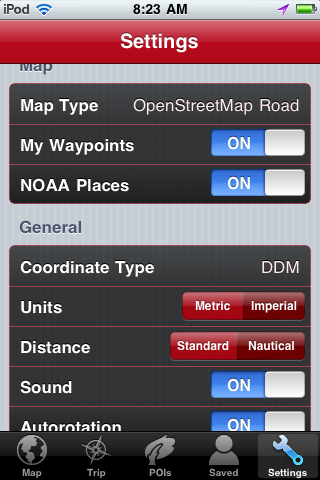
The Settings key allows the user to select the various setting for the app. These include map type, turning waypoints and NOAA places on, selecting coordinate type, units and distance.

As you can see EarthNC has made many nice improvements with this latest version. The one area where the app could improve is the charts. The NOAA charts and topo maps are very accurate and usable but are not the quality of the Navionics charts.

I am excited about the new features and look forward the more improvements as EarthNC Marine Charts matures. If your looking for a nice functional app with the addition of POI, EarthNC may work for you.


Friday, May 6, 2011

iSailGPS

Application: iPhone, iPad and iPod Touch
Function: GPS Marine Charting and Navigation
Cost: $7.99
Rating: ***

iSailGPS 1.0 hit the iTunes AppStore on April 29th.  The author Captain Larry James has put together a nice navigation app following his MacGPS Pro charting program. At first look this is an entry level charting app that uses NOAA RNC, Raster Nautical Charts and has a few feature that make it useful to the novice boater. NOAA RNC are supplied free by the Federal Government and many app developers have made good use of both the RNC and ENC charts.  This app does a nice job in display and transitioning to the next chart when needed. The tracking and waypoint features allow navigation to your favorite fishing holes.

I have reviewed several other GPS Charting apps with similar features with many costing less than the suggested price of  $7.99.

Features:
  • Up to 200 RNC charts stored on your device for use even while your device is not connected to a wireless network or cellular service.
  • Charts downloaded directly to your device while connected to the Internet.
  • Show your current location along with a track of where you've been
  • Go To waypoint to guide you to your destination.
  • Charts transition automatically as you sail, showing the highest resolution chart at your location.
  • Graph of the boat speed.
  • Record tracks even while your device is sleeping
  • Import GPX and LOC waypoints by email or iTunes.
  • Export GPX waypoints and tracks by email or iTunes.
  • Zoom and Pan the chart with full resolution.
  • Flexibility to use Degrees, Degrees/Minutes, Degrees/Minutes/Seconds, or UTM.
  • Ability to view Distance, Speed, Course, Heading & Estimated Arrival Time.
The My Location Page is accessed by selecting the soft key that looks like a snow flake at the bottom of the screen. The multi touch functions work for page navigation. Drag the screen around with one finger. Use two fingers to zoom in and out. Tapping  Two taps zoom in 2 times.  3 taps returns to the original scale.  4 Taps zoom all the way out showing the whole chart. 5 taps reset back to original.  That's alot of tapping.  The Mark button on the top of the screen creates a waypoint at your location.

Latitude and longitude are nicely displayed on the top of the page along with speed and GPS accuracy. When you start moving the course information replaces the GPS accuracy data.

The Go to Waypoint Page shows course, bearing, ETA and distance to waypoint on the top of the screen. Up to 4000 waypoints can be saved.  Waypoints can be added, deleted, saved, emailed or viewed on a chart.

The Track feature is selected by another soft key.  It allows you to delete your track or  initiate tracking and email your track or location if connected.  Tracking can be set up to track when using the app live or continue tracking when another app is being used or if the device is sleeping. This continuous tracking will eat up your battery if  your not careful.

The Chart List is accessed by a soft key at the bottom of the page. Charts can only be added when connected to the Internet through wifi or cellular service. Several charts of the same location can be selected based on scale. Charts can be added at your current location, by name or location or latitude and longitude.  There app offers several options to select the charts to display. Charts management features seemed functional and intuitive to the user.  The app allows you to save up to 200 charts for use offline when your not connected to the Internet.

If  you are a fan of the RNC charts and need a basic chart plotter as back up iSailGPS may be for you.  I personally like the ENC charts or Navionics. If your serious about a charting app look at several to find one that fits your application.