 Application: iPad Ver 5.0 or later
Function: Passage planning with currents and tides
Cost: Free
Rating: ***
I was paging through the many navigation apps the other day on iTunes and came across one I had not seen before. Track Pad is a fairly new app that has been developed by the folks at Ruddernuts. I like these guys already just for their crazy name. They have put together a simple and intuitive app that can be used in passage planning. It is designed primarily for sailors and calculates course and time to destination (TTD), calculations taking into various factors. For us sailors this is an invaluable tool.
Track Pad is a great little app that should be on every sailor's iPad. It is not available for the iPhone, so your out of luck there.
The app is not a chart plotter, a GPS or a weather app. It works independently from these devices to aid in your passage planning. It allows the sailor to compute tacking solutions at any point of sail taking into account user selected wind and current directions and velocities. Power boaters may also find it useful to calculate correct course settings taking into account wind and current conditions.
Tack Pad can use your sailboats Polar Diagrams to estimate speed and leeway. Instant calculations provide estimated time of arrival and detailed information of the required course to steer and intermediate tacking points. Current and wind speeds and directions can be adjusted on the fly as conditions change. Instantaneous calculations provide the user with the new course to steer.
Features:
- Drag and Drop multiple waypoints
- Tacking solution calculate on the fly
- Two pages for alternate routes
- Downwind tacking
- Estimate current speed and direction
- Estimate wind speed and direction
- Solve Course
- Reverse Course
- Add your boats polar diagrams through iTtunes
- ETA and distances /tubes
- Course to steer
- Estimated leeway
- Velocity made good
- Estimated speed over ground

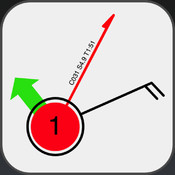
The vital parts of the course and tacking points are listed in the diagram to the left. C is for Course to steer, B is for Bearing, Wind barb, TR is for Track, D is for distance, T is for Time and S is for speed.
All of these values are estimates and are used as a good starting point in you navigational trip planning.
 The apps main display is used for creating the waypoints and adjusting the current and wind speeds and directions.
 There are a set of icons on the lower right side of the screen to access other features and settings of the app. The Top Page icon will allow you to select a second page for additional course calculations. The Arrows icon allows you to reverse the course and associated calculations with a touch of this button. The Small i icon is for information of the waypoints. The last Gear icon is for the settings page which is shown at the left.
Settings include velocity prediction programs (VPP) for three different boat characteristics. Polar boat performance settings and Leeway settings can be adjusted also based on your boats performance.
To start a course calculations just double tap the screen and start moving the points around the screen to estimate your intended route. As sailors we all know that wind and currents affect our boats intended course and speed. Tack Pad is programmed to make the calculations needed to come up with the course to steer taking into account these factors.
 The example to the right shows my last trip from Ft. Lauderdale to Bimini in the Bahamas. The trip as the crow flys is about 50 miles at a bearing of 117 degrees. The wind was about 12 knots right out of the east. Simply double tap the screen to add additional points if needed. Points can be removed by double tapping them again. A single tap on any point brings up the info screen for that waypoint.
The other important factor in this calculation is the Gulf Stream current. In this case I estimated it to be about 5 knots running northeast at about 18 degrees.
To adjust the current settings, I tapped and held my finger on green arrow. I moved my finger in a circle around the point to set the direction and away or towards the point to increase or decrease the current speed. The settings were shown at the bottom of the screen as I adjusted them. I was able to tap and hold the wind barb and adjust the wind speed and direction in a similar fashion.
The red coarse to steer line then automatically calculated an estimated time to destination of 9 hours and 11 minutes, speed of 7.9 knots at a course of 153 degrees to reach Bimini.
Using your finger to make these settings takes some trial and error but it can be done with some practice. In this example I did not have to tack at all so no intermediate tacking points were calculated. If the wind had been more on my nose, it would have calculated the optimum tacking point automatically.
 This slick little app can take into account your sailboats Polar diagrams. Polars are a graphical representation of the performance of your boat at different wind speeds and points of sail.
 In the settings menu, tap the Polar section to make changes to the Polar options. Settings can be made for main and jib or spinnaker configurations. Theoretical hull speed can be set here also.
Individual specific polar diagrams for your boat can be loaded in to the program using file sharing in iTunes. Open up iTune and connect your iPad. Select the APPS tab for your device and scroll down to Track Pad listed in file sharing. Simple drag or add the polar text file to this location. Make sure to change the file extension to .bp before adding it.
I am very impressed with this little app. I found it very easy to use and I liked being able to modify the settings to fit my boat's performance characteristics. It is very useful as a planning tool and is a good starting point for getting your boat headed in the right direction. In situations where you are dealing with strong current or wind this app will quickly give you a sense of how those factors will affect your desired course.
~~~Sail On~~~
Mark
This comment has been removed by a blog administrator.
ReplyDelete