Saturday, November 24, 2012

Where Yah Headed?

"I'm flying away
And that is where I stay
Right there in Never Neverland
I'd be flying, I'd be dying
For love and appreciation
Where mermaids would sing
And fairies would ring
Right down there in Never Neverland
And it's the second star to the left and straight on 'til morning
Or was it the second star to the right and straight on 'til morning?
In Never Neverland
In my Never Neverland"

 
Most boaters today rely on their array of electronic devices to tell them where they are and what direction they are heading.  GPS, chart plotters, multifunction displays, marine instruments, computers, iPhones and iPads all help the mariner get to where he is going these days. 

GPS was first developed in the 1960's primarily for military use. It was not released commercially until about 1990.  President Reagan issued a directive to make it available for civilian use after a Korean Airliner was shot down in 1983 after accidentally flying into prohibited airspace over the USSR.  The GPS satellite project launched 24 satellites into space between 1989 and 1994. 

Prior to GPS there was a system called LORAN C which used low frequency radio waves to help aircraft and ships determine their position and speed.  The system was developed by the US during World War II.  The land based LORAN beacons broadcast their signal up to 1200 miles. The system was officially shut by the Coast Guard in 2010 when it determine the system was no longer needed.

Prior to that mariners practiced celestial navigation which used a system of position fixes and angular measurements of celestial bodies in relation to the horizon.  The sun, moon, planets and some 57 stars could be used with a sextant to navigate the world's oceans.

From there we go back to the 2nd century China where it is thought that the first magnetic compass was developed during Han Dynasty. The compass is a magnetic pointer that aligns itself with the Earth's magnetic field.  The compass needle points to the magnetic north pole located in northeastern Canada.  This is not the same as true North which is the the north Pole.  The difference between true North and the magnetic North is called declination. Declination changes depending on where you are on Earth. These values are often printed on charts and need to be accounted for when navigating.

Even with all the high tech electronic gadgetry on board it is still nice to have a simple compass to use as a reference.  Looking through the iTunes store you will find that there at hundreds of options.  Lets look at a few compass apps that are available for the iPhone and iPad.

Commander Compass $3.99
Milspec compass
gyro compass
Maps
GPS tracker
Speedometer
Gyro horizon and inclinometer.


Compass 54 Pro $.99

Switch between true and magnetic North
Location coordinates (longitude, latitude).
Course
Speed
Altitude
Mph, feet units and Kph, meter units
Temperature Celsius and Fahrenheit
Humidity
Pressure
Current date and time
Current GMT time
12-hour and 24-hour format
Standard, satellite, hybrid maps.
Current location.
Location tracking

Digital Compass Free $Free

Display the course in degrees
Display the latitude and longitude
iPhone 3G, required
Must be moving to display course
Instrument style

Compass Easy $.99,

Magnetic North
True, North
Multi-Language
Supports Retina Display


Compass Go  $.99

Simple GPS compass
Accurate sun compass
Magnetic declination indicator
Bookmark your location via email
Email your location to others
Speed meter
Altitude meter

Digital Compass  $Free

Magnetic digital compass
Latitude and longitude
True North
Magnetic North


3D Gyro Compass $1.99

Gyroscope
3D compass
True North
Magnetic North
Orientation number display
Horizontal mode
Smooth motion flow technique.
Superb high quality graphic display


Free HD Compass for iPad $ Free

Unique free High-definition compass
Rustic style


Gyro Compass $ Free

GPS
Online map
Gyro Compass
Landscape mode
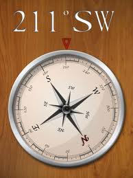


Compass HD $.99

Compass HD for iPad
Looks like a real compass.
Function in all orientations.
Analog and digital readings


These are just a few of the many listed in the iTunes store. They come in all shapes and sizes and with many different features. Download a few of your favorites and always know where your headed!

~~~Sail On~~~ /)
Mark

Wednesday, November 21, 2012

A Marine "Black Friday"


Well, Thanksgiving has not even started yet and my wife is talking about Christmas shopping on BLACK FRIDAY. Many stores are planning to open even earlier than Friday. Some are opening their doors on Thanksgiving day at 8:00 pm. You have got to be kidding! This Christmas shopping is getting out of control.

People have been camping out all week in front of Best Buy and Walmart stores to catch the early deals on Christmas gifts.  I like to save a few bucks and get a good deal, but camping out in this weather?

If your like me, you probably have been getting alot of email notices about the "BLACK FRIDAY" events. I don't know if this is just an American phenomena but I thought it would be a good idea to share the Marine boating and sailing deals I have been hearing about.

We can all use a good deal on boat stuff.  It appears to me that if the word Marine is on the box it costs twice as much. Not to worry my boating friends, here are some holiday deals that will save you some serious cash!
West Marine is currently having a Holiday sale with some gift items 30% off from November 13-26th.  Check their site again on Friday for more great online deals.

On Thanksgiving Day they are having a 15% off sale on their entire site. Just use the code BIG15 at checkout.

Get your captain an eGift Card from West Marine, that will be sure to put a smile on his face!

Marine Depot is having a Black Friday event with saving of 10-50% on some items. Their sale runs through December 4th.

Mauri Pro Sailing is another great boating gear and prices. They are having a 30% off sale on their closeout items. You can get free shipping for orders over $75 in the US. Redeem the coupon SHUS.

Jamestown Distributors has many great items on sale for Christmas and you can get free shipping on items over $50.00 until November 26 by using redeeming the code THANKS.


Defender Marine is another quality site with great merchandise and prices. Check out their Holiday Sale items.


Bass Pro Shops is having a 5 DAY SALE with discounts up to 50% on hundreds of items through November 25th. 


Boating Savings.com has a event on Black Friday as well. Check out their great deals.

Amazon.com Black Friday always has the best prices and the greatest deals on the net. Check out their Marine Electronics section.


Overton's is a major supplier of boating and marine equipment. Check out their Black Friday specials. Everyday free shipping, no minimum order.


Island Nautical  also know as the New JSI Marine Supply is another one of my favorite marine stores. Check out their wide variety of marine supplies.


APPs On SALE

There are a ton of navigation apps going on sale on Black Friday also. Most of these are for land navigation but they might be useful on a road trip.

  • Garmin Street Pilot for the iPhone on sale for $24.99 was 49.99
  • Magellan Roadmate North America $44.99 was of $59.99 
  • Magellan RoadMate USA  $34.99 was of $49.99 
  • Magellan RoadMate Canada  $29.99 was of $34.99 
  • CoPilot Live USA for iPhone  $2.99
  • CoPilot Live North America for iPhone  $9.99
  • CoPilot Live HD North America app for iPad  $19.99 
  • NAVIGON Mobile Navigator iPhone USA  $29.99 was $49.99 
  • NAVIGON Mobile Navigator iPhone $19.99 was $29.99
  • TomTom US, Canada, or Mexico  $34.99 Nov. 26-30)
Good luck to all you shoppers who are going to brave the stores on Black Friday! May the force be with you. You will not see me fighting over the Tickle Me Elmo dolls, I will be home working on another great blog entry.

If you know of any great deals on Marine hardware or electronics, let me know and I will post them here!

~~~Sail On~~~ /)
Mark

Sunday, November 18, 2012

Furuno NAVnet - Remote and Viewer Apps

Application: iPhone, iPad
Function: Furuno NAVnet TZtouch Remote Control
Cost: Free
Rating: *****

Furuno has been a leader in providing state of the art marine navigation and radar systems for many years. Their latest products are a line multifunction touch screen screen displays called the NAVnet TZtouch.  These come in a 9 or 14.1 inch models called the TZT9 and TZT14.

Many companies are producing apps to remotely view and control these multifunction displays. NAVnet is no different and has produce two apps for doing just that. The NAVnet TZtouch series has built in WiFi which give you the ability to connect to the Internet to download weather data or connect with other mobile devices.  The iPad and iPhone can then be used to view or control your onboard systems.

It is easy to connect your mobile device to the TZ Touch units. Up to three mobile devices can be connected to the TZT9/14 device network.

The TZT9/14 serves as the access point for the iOS devices.  To set up a local network follow these steps.
  1. Select Wireless LAN Setting from Menu on the TZT9/14 unit. Go to Menu > General > Wireless LAN Setting.
  2. Select Create Local Network from Wiress LAN Settings.
  3. Create an SSID name and password.
  4. With your iOS device go to Settings/WiFi. Select the SSID of the TZT9/14 and enter the password you setup in step 3.
  5. Once the iPad connects to the wireless LAN you are then ready to start the app.
The NAVnet Remote app will provide full control of your NAVnet TZ9/14 inch displays. Any screen that can be viewed on the TZtouch screens can also be viewed and controlled on your iPad.  This gives you complete freedom to move about your yacht and have complete access to all your data and control of your navigation, radar and sonar systems.  

You must first be connected through WiFi to the TZtouch display. Start the app and it will automatically search for the NAVnet wireless network. 

Once connected you can use all the regular multi-touch display functions and gestures to zoom in and out and pan around the screen. 

Menus and features can be accessed on the sidebar menu system exactly as you can on the TZT9/14 displays. Routes, waypoints, charting, sonar, radar, overlays and orientation can all be controlled from the iPad. Any changes you make on the iPad are mirrored on the TZ9/14 multifunction displays.

The soft key menu at the bottom right contains four buttons for controlling the features of the app.  Settings can also be modified using the wrench icon.

If you just want to view data  from your NAVnet multifunction display, you have the option to use the Viewer App. The NAVnet Viewer app also connects wirelessly to the TZ series displays and allows you to view any data that is available on the multifunction displays.

The NAVnet viewer app connects wirelessly, exactly the same what as the NAVnet Remote app shown above. Once connected you can view Fishing, Sailing, Ship, Navigation, Environment and Engine data on your iPad or iPhone.  The wireless connection give you the ability to have a data repeater anywhere on your  boat.

If your fishing you can have your iPhone running the app to view the sonar and fish finder display. You can have instant access to the data you need where you need it.

There is a short YouTube video showing some of the features of these apps.

I do not have a NAVnet MFD myself, so, I was not able to put it through its paces. The app does appears to have all the displays, data and features I would want.  The Custom section also allows the flexibility to create up to four pages of additional displays with any of the 22 different data types.

The displays are large and well lit.  The setting options provide the ability to change between light or dark backgrounds. This optimizes the night or daytime viewing of the displays.

The image to the left is the Sailing display which show the bearing, course over ground, range and speed over ground.  GPS position data and cross track error are shown with a graphical display. 

Double tap on any of the displays to zoom in on that particular data. Double tab again to go back to the whole display.

If you are a Furuno TZT9/14 owner, these apps are another great tool to have on your mobile device. They give you the flexibility to have another way to view and control all the navigation and data monitoring features on you yacht. 

Is anyone using these apps? I would like some feedback from some actual users. Let us know what you think?

~~~Sail On~~~ /)
Mark


Wednesday, November 14, 2012

Free Raymarine App Offer - Oh Yah!

Application: iPhone, iPad, Android phone or tablets
Function: Raymarine multifunction display control
Cost: FREE
Rating:*****

Raymarine knows how to celebrate!  They are offering their RayControl and RayRemote apps free for a limited time only. See the notice here.  You heard me, FREE, so go and grab them while it lasts.  The apps require that you have a Raymarine C or E-Series multifunction display with software updated to 4.27 or higher.  They will not work on any other MFD.

This freebie is offered in celebration for their RayControl App being nominated for this years METS DAME Award.

The RayRemote app transforms your iOS phone in to a remote for the Raymarine multifunction displays. This allows you to remotely control your electronic sonar, radar, charting and night vision cameras from your phone. There is also an Android version of the app available too in the Google Play store.


The RayControl app is used by your iPad to take full control of your Raymarine MFD.  You can control many of the functions of your MFD right from your iPad. This app gives you unmatched versatility and freedom to move about your yacht and be in control from anywhere onboard. This app also requires that you already have an E or C-Series MFD installed with WiFi. An Android verion is also available in the Google Play store.


If you own a Raymarine C or E series MFD this is an opportunity to add some additional functionality for free.  Thanks again Raymarine and congratulations on your nomination!

~~~Sail On~~~ /) 
Mark


Monday, November 12, 2012

ActiveCaptain and the Companion App

"Interactive Cruising Guide"

Coastal cruisers are always in need of information. What is the best place to fuel up?  What is the best marina in Ft Lauderdale? Where can I find a transient slip in Jacksonville?  In the past mariners shared this local knowledge with each other by word of mouth.  If you were lucky the information was up to date, if not, you may be navigating into troubled waters.

The information age arrived many years ago and mariners now share this data on the Internet through various sites. Today we have message forums, email, Facebook and Twitter. All of these allow information to travel at the speed of light.

Riding this wave of information is a site called ActiveCaptain.  ActiveCaptain(no space) is the creation of Jeff and Karen Siegel and has been around since 2007.  The Siegels can be found cruising the inter coastal themselves aboard their 53 foot DeFever.  It looks like a great way to mix a little work and pleasure.

Their free website contains the Interactive Cruising Guide which graphically shows all the marine points of interest created by it's users.  Simply zoom into an area and start exploring.  Create an account and add points on interest yourself.  The webpage however uses Adobe Flash which is not supported on the iPhone or iPad so you will have to use a Windows or Android browser to view it.

The marketing plan is designed to get sponsors to sign up to support the site. They are then able to get their marinas, restaurants and facilities listed on the ActiveCaptain database. Additional features allow them to promote their facilities.  It will cost you $499 a year to be a sponsor. Boaters then have the chance to add, rate and comment about points of interest not only in the US but at other points around the world too.

ActiveCaptain uses crowd sourcing to create the vast database of information that mariners share and use.  Crowd source is kind of a new "buzz word" to the marine community.  This process allows many users to create points of interest that others can use or comment on.  The power of many people sharing information sound like a great idea but it poses some problems too.

The first question that came to my mind was, how do they keep from getting alot of junk or spam data from being entered?  ActiveCaptain has an extensive validation and verification process to check out and verify that the points of interest and changes to their database are correct. They do all the work for you, so if the data is in the database you can trust it. If you find it is not right make the change or correction and they will mark it as pending until they can verify it.

ActiveCaptain also makes the database available to app developers.  This makes it a no-brainer for developers to include it in their PC or mobile app.

There are about 20 marine apps or charting programs that utilize the ActiveCaptain database.  It is available for Windows, Linux, OSX, iOS, Android, Palm and Windows Mobile.

The screen shot to the left shows an app called SEAiq that has recently integrated the ActiveCaptain points of interest.  The different colored markers represent different types of data. The Yellow markers are hazards, the Blue ones are local knowledge, Green are anchorages and the Red ones show marinas.


Just tap on a marker to show the information related to that icon. You can keep drilling down on the specific markers to show all the related details and contact info.

The Location Information to the right shows the POIs on the Fort Meyers Beach location.  Tapping on one of the Marinas will list General information, Contacts info, address, navigation data, dockage, fuel, services and any related reviews.

Additional markers for Local Knowledge and Anchorages are shown too. Click to your hearts content and explore all the great information available.

The database is downloaded to the app and can be used even if you have no cell or Internet connection.

"The Companion"

My trusted companion is my dog, "Piper" but ActiveCaptain has something a little different in mind. 

One new feature that ActiveCaptain has been working on for several years is called the ActiveCaptain Companion.  The concept was shared in one of the ActiveCapatin's weekly newsletters back in November of 2011. Their recent newsletter revealed a few more details and a video showing some of the capabilities that we can expect to see. 

This is a software application that will run on your PC, Mac OSX, Apple iOS or Android phone and tablet devices.  It is meant to enhance the cruising experience by providing a list of upcoming hazards, bridges, weather and points of interest that might be interesting to the traveler.  It can be set up to produce audible alarms or voice notifications.  Having route and GPS data, the Companion could warn you of upcoming hazards or weather along your route.  It is like having Siri as your cruising partner.

The Companion brings some artificial intelligence to your travels, making them safer and keeping you informed of the possibilities ahead.  My mind starts to race when I think of the many things the Companion could alarm the user to.  Think of the Companion as your new 1st mate. It will always be on watch collecting data and notifying you 24 hours a day if needed.

I think there would have to be a huge disclaimer when using this. I could see someone relying on this software to keep them out of trouble rather than relying on their own eyes and ears to keep track of problems ahead.

ActiveCaptain continues to produce value added products for the marine industry.  I reviewed their most excellent, free Drag Queen anchor alarm app a while back.  Log into ActiveCaptain and get started today. You can use it on the web or through one of the many apps that support the POI database. 

The Companion will be out soon, no firm date yet, so stay tuned!

~~~Sail On~~~ /)
Mark