Blog Pages

Saturday, December 16, 2017

iNavX Marine Charting for Android Devices

Application: Android Smartphones and Tablets
Function: Marine Charting and Navigation
Rating: *****
Price: Free, with in App purchases for additional features


iNavX has been working for over a year to bring you their Android version of their very popular marine charting and navigation app.

 The iOS version has been around for years, but not until now have Android users been able to use this awesome app. The app is now available in the Google Play store.

I have used the iOS version for years and appreciate the vast number of features in the app. All of these features are now available in the Android version. Over the years I have written numerous articles and tutorials about iNavX iOS for a good reason.

It is still ranked #1 on my list of Best Marine Charting apps. The new owners and developers of iNavX have finally delivered an Android version that many boaters have been looking for. The MacSailing message board for iNavX iOS is a great resource for anyone wanting to learn all they can about the iOS version of the app and it's capabilities. Hopefully this blog post will reveal some of the features of the Android version.

Advanced Navigation Features:
  • Create waypoints and plan routes and navigate between them 
  • Plot your position in real time using devices GPS 
  • Pan, zoom and rotate charts 
  • Electronic Compass 
  • North Up/Course up 
  • Multiple chart vendors 
  • Marine vector and rater charts 
  • Quickly measure bearing/distance between points 
  • Track log allows you to record your actual route 
  • Import/Export data in KML (Google Earth) or GPX format 
Advanced Instrumentation: 

  • Acts as a repeater for popular marine navigation software MacENC 
  • Supports NMEA data over TCP/IP using WiFi 
  • Integrates with external GPS, AIS receivers and transponders 
  • Connects to onboard instruments, depth, speed, wind, engine batteries etc. 
Other Features: 

  • GRIB Weather Forecasts, wind speed, direction, pressure 
  • Tide/Currents 
  • Anchor Alarm 
  • AIS Alarm 
  • Port and navaid search 
  • Tracking Log History 
  • Import and Export waypoints, routes with popular GPX and KML formats

Onscreen Navigation:

All of the Android screen and button functions are incorporated into the app. The app has five soft keys at the bottom of the main Chart screen.  The keys from left to right are, Chart, Waypoints, Routes, Track and Settings

The soft key menu can be toggled off and on by using the big black + plus sign on the chart.

On top of the Chart screen you can see an active compass and instrument display of heading, latitude, longitude, course over ground and speed over ground, altitude, connection, location error and time. Each of these can be tapped for a full screen view.

Charts:
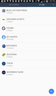
The new Android version of iNavX is available for free for Android mobile devices and includes a basic world map and location services. iNavX Pro can be purchased for $19.99 per year and provides premiums service such as enhanced navigational features, setting waypoints, routes and tracking. This feature is free to all users until the Miami Boat Show ends on February 15th.

Charts can be purchased with in-app purchases directly in the app. This is easier than using the xTraverse site that the iOS app has to use. Purchased charts are good for up to two devices. 

Navionics Android Tablet charts can be purchased from $69.00-$89.00 per region. Navionics Charts for your Android smartphone will cost $29.00 to $59.00 per region. Other chart types from Explorer, Delius Klasing, Fugawi, Canadian CHS, Blue Latitude, NV Charts, Theyr Weather, Waterway Guides, Trak Maps and Solteknik can also be purchased.

I download the app on my Samsung Galaxy tablet with no problem. I am not sure if there is a list of compatible devices. The Google Play store should tell you if it is compatible with your device. 

Chart updates are free for one year then the charts must be purchased again for continued updates. If you download them all to your device you can maintain that copy. The chart purchases include one free month of iNavX Pro. All charts can then be activated and downloaded to the iNavX app on your device for offline viewing.

Waypoints: 

Waypoints are the building blocks of navigation and the routing function within the app. In iNavX there are two ways to create waypoints.

The first is to simply tap the chart screen once where you want to place a waypoint. A banner at the bottom of the screen will open up with options of New Route, Add Route ad GoTo. On the upper right corner of the banner you will see a pencil icon. Tap this to pen up the edit the waypoint's name and icon or color.  

If you want to move a waypoint simply tap the waypoint icon on the map and move it around around to where you want it.  I found the waypoint icons too small and very hard to tap and move around to where I wanted. Bigger waypoint icons would be a plus.

The second way to create a waypoint is with the Waypoint menu selection on the bottom of the screen. Tapping this brings up your list of waypoints. Tap the blue + plus sign in the lower right to add a new waypoint. You can then edit the name, coordinates, icon color and the description of the waypoint. Swipe left on any waypoint to Hide, Go To and Delete.
Routes:

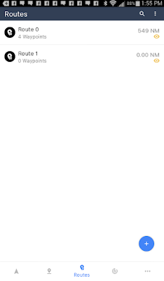
A route is simply a collection of waypoints that make up the path to your destination. To create a route select the Routes soft key at the bottom of the main Chart display. 

On the route display you will see a blue + sign in the bottom right hand corner. Selecting this will add a route and take you into the route creation and editing page. The new route will be given an name like Route 0. 

You can change the name of your route by tapping the pencil icon in the upper right corner to rename the route. The three vertical dots will allow Go To, Scroll To, Duplicate, Invert, Open With and Delete.

Once a route is selected waypoints can then be added with the blue icon in the lower right corner. This requires that you created waypoints in the previous waypoints section.


Tracks:

Tracks are simply a digital recording of the path that your vessel has taken as it travels through the water over time.
The iOS version of iNavX keeps track records for up to the last 500 miles traveled. I am not sure what the limitation is for the Android version. 

To start Tracking select the Track soft key at the bottom of the main navigation display. Start tracking by tapping the red icon in the lower right corner of the display. The app will record your distance, average speed, and elapse time while tracking is enabled. Track points are recorded every 20 seconds. The Settings (gear icon) with the tracking function allows track back and 3 levels of tracking precision.

With a Track selected, selecting the export icon (three connected dots) allows download of your tracks to your X-Traverse account in a GPX or KML file formats. To remove your track logs simply swipe to the left on any of the recorded tracks.

Another neat feature is the Background Recording. Even with with the iNavX app suspended it will continue to record track information. Make sure to have your device plugged into power, if not, it will drain your battery rather quickly. This feature will only work with the devices Location services.

The last icon on the bottom of the screen will bring up selections for Account, Instruments, Tool & Forecasts, Settings and Help. Logging into your xTraverse account will allow you to store all of your waypoints, routes and tracks. You can upload these for storage and download them for use on other devices.

Instruments are a very powerful part of the iNavX app. Selecting this displays course over ground (COG), speed over ground (SOG), heading (HDG), rotation (ROT), altitude, connection type, location error, latitude, longitude and system time. If the app is connected with WiFi to your ships instruments additional data will be available.

Once navigating to a waypoint additional data including bearing to waypoint (BTW), distance to waypoint (DTW), velocity made good (VMG), anchor drift (AAD) and cross track error (XTE). Tapping on any of these instruments creates a full scree display of the value in digital form.

After working with the app for a while it seems to have pretty much all the functionality that the iOS version has.  The iOS version had TCP/IP connectivity which I was not able to find on this Android version. The Google Play store says it is available with an in app purchase but I was not able to locate where to make the purchase.  If anyone know, please let me know.  I will keep looking. It may not be available until some charts are downloaded.  

Give me some feedback on what you think of this version. I think it is a big win for iNavX and all of the Android user out there. 

~~~ Sail On ~~~ /)
Mark

Saturday, November 4, 2017

Garmin Buys Navionics, What is Next

Very BIG news in the marine industry last week when we learned that Garmin acquired the Navionics Corporation. On October 27th Garmin issued a press release stating that they acquired the privately held Navionics company popular for their marine charts and mobile marine apps.

This comes on the heals of Garmin's purchase of the ActiveCaptain's crowd sourced marine database in May and the purchase earlier this year of Delorme which is known for their popular inReach two way satellite tracking and messaging device.

Wow, this bring up numerous questions and concerns as Garmin continues to gobble up the competition.  The purchase of these companies and their technology should give Garmin a real advantage over other chartplotter and app providers on the market.
  • With Garmin purchasing Navionics, will they continue to provide charts to other manufacturers such as Raymarine, Simrad, B&G and others? 
  • Will they continue to support the Navionics and BlueChart Mobile apps?
  • Will Garmin continue to support the Navionics charts?
  • Will they continue to provide the Navionics app features such as auto routing and crowd sourced sonar charts?
  • Will they continue to provide the cost effective charts for app?
I am first excited because Garmin will hopefully bring all of this new technology into their main chart plotter products and continue to interface them with apps on mobile devices. This will spawn new features on their main line of products and make them the leader in the industry.

On the other hand I am more concerned that by gobbling up the competition the popular Navionics app will be no longer be available.  I have never been a big fan of the the Garmin BlueChart Mobile app.  It had a clunker interface and lacks many features we all wanted in a stand alone chart plotter app.  Garmin's BlueChart Mobile app was never build to be a stand alone marine app because Garmin did not want to cannibalize their chart plotter business.  They would rather have you spend $1000 on a chart plotter than $50 for an app.

As an avid Navionics app user I would hate to see the Navionics app disappear. Millions of sailors around the world use the Navionics apps on their mobile devices and to lose them would be a step back in time. I guess we have to wait and see what Garmin does with these new products.

Recent chatter on Facebook and other social media has already discovered that the Garmin's BlueChart Mobile app is not longer available in the iTunes Store.  This has many people upset since this app had a large following of users.  I can only guess that Garmin is working on a new iOS mobile app to replace it or will rely on the Navionics iOS apps going forward.  If you have the BlueChart Mobile app on your phone or tablet is should still continue to work. It will fail at some point when Apple upgrades the iOS software or Garmin no longer supports it. The BlueChart Mobile apps was popular because it supported the ActiveCaptain points of interest database.

There are a host of other apps that incorporate the ActiveCaptain crowd sourced data. Pick one of them to continue accessing the database and making reviews. SEAiq, Navimatics Charts and Tide, Skipper, Aqua Maps, Sailtimer and Plan2Nav are a few that support ActiveCapatain.

A new Garmin ActiveCaptain app for Android devices is available in the Google store. Looking at some of the reviews, people are having issues logging into ActiveCaptain and the price of charts is now $319.  I am not sure why the charts are so expensive.  Hopefully if you purchase the charts they would be available on all your devices including your chart plotter. No one is going to pay $319 for chart for just a mobile device. Maybe this is how Garmin plans to kill the mobile device charting apps.

Update November 11, the iOS version of the Garmin Active Captain app came this week also download it from the app store. I will do a full review of that in the near future.

The Navionics Apps appear to still be functional and available on the iTunes Store. I would expect some changes to these in the future as Garmin decides what to do with them. I would urge them to continue to support these apps due to the large number of active users worldwide.

With all of these acquisitions Garmin is strategically aligning itself to be a leader in the marine industry. My hope is that it will continue to support the already great mobile device apps out there instead of shelving them to spur on their chart plotter business. If they do not continue to support the Navionics apps I will be one upset sailor along with many others who use them everyday!

~~~ Sail On ~~~/)
Mark


Sunday, April 30, 2017

St Martin Charter 2017

Occasionally I go off topic and write about something different than marine apps.  In March of 2017 we spent two weeks in St Martin and the surrounding islands on a charter catamaran sailboat.  Since that time I have been busy editing all the pictures and video that I took during the trip.  I recently purchased a DJI Mavic Pro drone so you will see some of that footage in the videos also.

Once I get the videos done I will get back to the regular scheduled programming of reviewing marine apps.

In the mean time check out some of the videos from our most recent trip to St Martin and some of our previous charters in the British Virgin Islands. Give them a thumbs up(Like) and Subscribe to my YouTube channel if you like!  Thanks for watching!


~~~ Sail On ~~~ /)

Mark

Saturday, February 11, 2017

RaceQs Regatta Sailing App

Application: iPhone, iPad, iPod Touch, iOs 6.1 or later
Function: Sailboat Racing, Race tracking and recording
Rating: *****
Cost: Free

RaceQs is a fairly new app aimed primarily at sailors who either run regattas or race their sailboats.  The app can be used by all the sailors in the fleet to record their track and data during the race. The RaceQs website is then used after the race to review the play back in 3D. If you have ever watched the Americas Cup racing, the same graphics and analytics can be performed on your races. The app has many great analytical capabilities that can help any sailor improve their racing performance. Even if you don't race the apps tools allow you to record your tracks and help improve your sailing ability.

The app can be use to record your boats speed and movements using the phones internal, GPS and gyroscope and accelerometer. You can link you GoPro footage to the recording also to improve the playback experience.

Features:
  • Race Organization and Management
  • Free app and RaceQs account
  • One touch race recording
  • Max and average boat speed
  • Course
  • Velocity Made Good (VMG)
  • Roll
  • Pitch
  • Yaw
  • Drift
  • Track
  • Race Analytics
  • Wind direction from meteorological data
  • Real time upload
  • 5 minute delayed play back on website
  • Works below deck
  • Privacy controls
  • Website 3D race movie playback
  • Race analysis
  • Personal website journal page
  • Add crew list and duties
  • Notification email of events
  • Social Media Sharing

Download the App from iTunes to get started. The app is free so encourage all your crew and other sailors in your club to do the same.

Create an Account:

Creating an account is needed to be able to access all the features of the app and and RaceQs website. You can skip registration and use it to just record your tracks but you will not have access to the website features.

Having a user name and password will allow you to access your personal journal page on the RaceQs website to be able to review all your tracks and saved race data.

The website also has some social media and networking features which allow the users to organize races and contact crew members.

Record the Race:
Recording a race or track is done with a push of the Start Tracking button in the app. Only one person on board the boat needs to record the race.

A phone or tablet can be use to record the race. Make sure the device is secured so it does not slide around. The top of the phone should be facing forward towards the front of the boat. The device will then record the correct direction, pitch, roll and yaw of your boat.

The Live Streaming function can also be turned on in the app. This features allows the data from your phone to be streamed to the website with a five minute delay. Your friends or the crew back at the yacht club can watch the race in almost real time. The data is delayed for five minutes because other boats can also view your performance, tactics and data on the website.

Cell service for your device is required for live streaming. If you do not have cell service the data is still recorded and can be uploaded over WiFi when you return from the race.

Accessing the apps functions are done through several buttons at the bottom of the app. Preset Start allows the user to set up the time to automatically start recording data in the app.
Tracks is a list of all your boats recorded tracks or races. These are listed by date, time and included miles sailed and time.
Settings include, Auto shutoff, roll, pitch and yaw settings, a setup for an external data connection via TCP/IP or UDP WiFi protocol is also provided. This would be used if you had an external GPS source for this data.

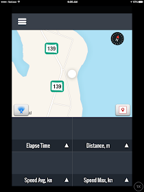
The real time display shows a map of your boats track as it records your data. The real time data and track are displayed below in digital form.

Real time data includes Elapse Time, Distance, Average Speed and Maximum Speed.

The track display has a Compass in the upper right side of the screen.  This displays when the app is in the Course Up mode.  The Blue Course icon in the lower right let you toggle between Course up and North Up modes.

The Marker icon in the lower right of the map let the user drop a marker on the screen to note the start line or marks on the course. Once you drop a mark you cannot move it. If the mark is not in the place you want it, delete it and drop a new one in the correct location.

These markers can the be used on the website to set up the race course and place marker buoys for an accurate depiction of the course.

Fleet Race Replay:

This is where is gets fun! Once the race is completed everyone should upload their boats track data to the website. A 3D movie replay of the race can then be created and viewed by the whole fleet.

The RaceQs app works with any type of boat. The app uses your phones GPS to know which boats are sailing in the same geographic area at the time of your race. Boats can be divided into different fleets if needed by entering the start times for the different fleets.

The virtual course can be set up by anyone who has access to the replay. Once it is setup it can be viewed by all race participants. Setting up the course involves placing the start line and marks around the course.  The playback allows for an in depth analysis of each boats performance and analytics during the race.

When viewing playback of your tracks or races you can select between course view, fleet view, match view, front or helm view. This display is similar to the Americas Cup graphics and views of those races. Course view is the most general and provides an overall view of the boats and the course. Fleet view shows the view of all boats in the race. Match view allow comparison of any two boats performance metrics side by side.


Analytics:

RaceQs has many powerful analytical tools to review the performance of your boat. Color coding can be added to each track of the boats in the race. This allows the viewer to easily track the different boats around the course.

Groove line analysis shows when the boat is sailing the fastest and areas when it was showing instability.

Two boats can be selected during the playback to show the distance and separation of the boats as they tack and progress around the course.

The Dashboard is another tool to analyze SOG, VMG, heel and drift. This performance data can be displayed for any boat as it progresses around the course. The Wind shadow is another analytic that shows the boats lee bow zone and aft wind shadow of your boat. A complete list of video tutorials can be found on the website and YouTube to set and use the app and website features.

I have not had a chance to use the app yet because it is still winter here in South Dakota. As I look out at the our lake it appears to be more of an ice rink right now. Is anyone using the app? If so, please comment below and share your experience.

The sailing season will soon be returning for us in the higher latitudes.  Get your sailing club members signed up for RaceQs to be able to record your races and use the analytical tools to become better sailors.

~~~ Sail On ~~~ /)
Mark

Saturday, January 28, 2017

Social Media Sailors, YouTube and Patreon


If you follow my blog you are probably some type of boater and if you do Facebook or watch YouTube you have probably run across a new wave of social media sailing channels.  I have been following some of these on Facebook and YouTube for years.

Before the Internet in the early 1990s, most of us never knew that it was possible to sail and cruise on a private yacht around the world. Those that did it back then did it on the cheap, were independently wealthy or sponsored by some large corporation. The world wide web allowed many of these sailors to start websites and blogs to share and document their adventures. As cruising caught on some boaters would write magazine articles and books about their travels and attend a few boat shows to make a few bucks to pad the cruising kitty.

Fast forward 20 years and we now have a younger generation finding out that they can go cruising now and pay for it along the way.  Cruisers can now develop an income stream to support a cruising lifestyle by developing content and posting it on social media sites like YouTube, Instagram, Facebook, Patreon and Twitter. Social media is no longer just a fad, it is a multi-billion dollar business.  Many young and old cruisers are becoming savvy at harnessing social media to buy their freedom and live and share their dreams.

Many of these millennial aged kids are taking to the high seas with little or no sailing experience and documenting all their exploits on YouTube. It make for some entertaining video. I have found that the most successful channels usually include some sort of hunky guy as captain and some very attractive young female sailors as crew. This usually makes for an interesting dynamic on board. Who doesn't like a little eye candy to keep the videos interesting. Throw in some sailing, sun, sandy beaches, rum, bikinis clad babes and you have a hit! That by no means is the only successful formula for a sailing YouTube channel. There are many channels which feature older less hard bodied sailors on board so their is hope for all of us.

YouTube  can been a steady source of income for many sailors who post videos.  YouTube pays channels advertising revenues which can be very lucrative if you have a large following and popular video content. The secret is to provide consistent and predictable content that people will continue to follow week after week. The more traffic you drive to your site generates more clicks by your viewers on the adds provided by Google.

Another site that has really become a gold mine for many of these cruisers is Patreon. Patreon is a crowd funding site that allows people to support many types of content creators. Sailors who produce videos are now finding a second income stream from developing Patreon followers and supporters. Followers can sign up to donate from $1-$50 per video to help support the sailors as they travel.

The website notes that more than $100 million has been donated to creators on the site since it started in 2013. This is such a unique concept that I had a hard time getting my head around it.  I guess there are millions of people in this world that are living vicariously through these creators and are willing to pay and support them to continue providing this content.  It is truly a win/win for both parties.

There has been some controversy around this in that some consider it a form of "Internet begging" of sorts while others consider it as just a tip for appreciating the content put together by these hard working content creators. I tend to agree, if you appreciate some one's artistic abilities or creation you should be able to support them if that is in line with your beliefs.

I have put together a list of the most famous, successful and profitable of these YouTubers and Patreon creators.  Some are just on YouTube while other subscribe to many forms of social media.

Established Channels:

Photo courtesy of  Distant Shores
Distant Shores
Creators: Paul and Sheryl Shard - Canadian
YouTube:Distant Shores
VIMEO: Distant Shores
Patreon: No
Website: Distant Shores.com
Boat: 49 ft Southerly sail boat

Synopsis: Paul and Sheryl have been producing an award winning TV show called Distant Shores for over 15 years. They built their first sailboat and set out from Canada to travel the the world produce videos for TV, DVD, YouTube and Vimeo. They provide breathtaking professional video and commentary of the places they visit. The videos are more of a documentary travel series. Most of the series are for sale while some shorter teaser clips are provided for free on YouTube. I have been following them for over 10 years and enjoy the detail and amount of work they put into their projects.

S/V Delos
Creators: Delos Brian and Brady Trautman - American,
Karin Syren - Swedish
YouTube: S/V Delos
Vimeo: S/V Delos
Patreon: SV Delos
Website: S/V Delos.com
Boat: Amel Super Maramu 53ft

Synopsis: Older brother Brian discovered the sailing and cruising lifestyle and bought a boat.  He sold everything and quit his job in his early 30s to sail the world for a few years. He was joined by his brother Brady for the Pacific crossing and the two have been sailing now for 7 years.

While cruising the South Pacific Brady and Brian met Josje Leyton and Karin Syren who have become the "Delos Tribe" as they liked to be called. They have had various other family and friends along as crew during their travels through southeast Asia and across the Indian Ocean. The videos have improved over the years and they provide a quality product.
Photo courtesy of Sailing Delos
These two ladies are young, blond and attractive and very capable sailors. They also add a great deal to the visual appeal of the videos.

The videos are full of sailing, snorkeling, diving and exploring of all their destinations. The crew parties quite a bit and enjoys mixing with the locals at each destination. They have a very successful YouTube following with over 150,000 followers and earn almost $6000/video on Patreon.

Sailing Sophisticated Lady/Ambient Real Life
Creator: Rick Moore - Canadian
YouTube: Sailing Sophisticated Lady
Vimeo: No
Patreon: Ambient Real Life
Website: Ambient Real Life.com
Boat: Jeanneau 51

Photo courtesy of Ambient Real Life
Synopsis: Rick has been sailing the Caribbean for over 10 years and produces some of the best videos of the islands I have seen. He started with his Ambient Real Life series on YouTube and has since provided others series to keep it fresh.

Rick travels between the Virgin Islands and Grenada each season spending time at each island shooting video, flying drones, working and enjoying what the local islands have to offer.

He has had a constant stream of charter guests, family and other women on board over the years which has made it interesting. He augments his lifestyle by having charter guest, doing professional video work, YouTube and most recently Patreon.

Sailing La Vagabonde
Creators: Riley Whitelum and Elayna Carausu - Australian
YouTube: Sailing La Vagabonde
Vimeo: No
Patreon: La Vagabonde
Website: Sailing La Vagabonde.com
Boat: Beneteau Cyclades 43

Synopsis: Riley had a life changing accident which made him question is there more to life. He decided to buy a sailboat in Italy and happened to run into another Australian, Elayna who quickly became his love interest and first mate. The two had little or no sailing experience but that did not stop them from sailing through the Mediterranean, across the Atlantic, through he Panama canal and across the Pacific. They posted their first video in November of 2014 and have since posted close to 70 videos of their travels.

Photo courtesy of La Vagabonde
Elayna started sharing the videos to keep family and friends up to date on their travels. Soon a following of over 250,000 YouTube followers fell in love with this cute young couple.  The two are very relaxed and down to earth. Their videos started out very crude but have always had a sense of freshness and honesty about them. Elayna is the artsy guitar playing beauty who does most of the videos and commentary. Riley has this wild curly hair, collection of strange hats and his famous mustache which is immortalized in their sailing logo. The two love to free dive and fish to augment their food supply. They are now able to support themselves through YouTube and Patreon where they now receive almost $9300 per video. They will be moving onto a new Outremer 45 catamaran in the spring of 2017 funded by their social media sites.

Gone with the Wynns
Creators: Jason and Nikki Wynn
YouTube: Gone with the Wynns
Vimeo: Gone with the Wynns
Patreon: The Wynns
Website: Gone with the Wynns.com
Boat: Leopard 43 Catamaran

Synopsis: The Wynns are new to sailing but were very popular YouTubers while they toured the US and Canada for 5 years in various recreational vehicles, RVs. They literally just move out of their motor home and onto their 43 ft catamaran to continue their travels. These two are a riot to watch and are quickly becoming one of my favorite channels.  These two are such a cute couple and seem to always be impeccably and stylishly dressed. Its like they were plucked right out of a JR Crew magazine or something. They both are very personable and engaging on the camera and always seen natural in their videos.

Photo courtesy of Gone With the Wynns
Jason has a background in photography which is evident by the many beautiful pictures on their website and Instagram.  He says he found the video button on his DLSR one day and has been making videos of their travels ever since. His photography skills have helped him produce amazing video of all their travels.

Nikki is this cute little bubbly gal that seems to take on any challenge with gusto and a can do attitude. She has quickly become proficient as a sailor and skipper of their new 43 ft catamaran. Her collection of sunglasses and snappy boating attire are endearing to her followers.

Sailing has been a huge learning curve for these two but they are picking it up fast and documenting all of the challenges. If you are a total newbie to boating, their videos will walk you through the whole process of purchasing a boat and gaining the experience to head offshore.

Photo courtesy of Chase the Story
Chase the Story
Creators: Tasha and Ryan
YouTube: Chase the Story Sailing
Vimeo: No
Patreon: Chase the Story
Website: Chase the Story.com
Boat: Fontaine Pajot Helia 44
Photo Courtesy of Chase the Story

Synopsis: Tasha and Ryan sailed to the Caribbean on their first boat Hideaway. They came back and sold their businesses in New York and bought a new Fontaine Pajot Helia 44, "Cheeky Monkey" in France and have since sailed across the Atlantic, through the Caribbean, Panama Canal and across the Pacific.

They have brought on several friends and crew to help sail, take video and produce their content for YouTube.  The videos are high quality and well done. They cover the day in the life of a cruiser and the many exploits of the crew.


Follow the Boat
Creators: Jaime and Liz - British
YouTube: Follow the Boat
Vimeo: No
Patreon: Follow the Boat
Website: Follow the Boat.com
Boat: Oyster 43
Synopsis: Liz and Jaime  and their cat Millie have been cruising on their 43 foot sailboat through Mediterranean and southeast Asia for over 10 years.

Photo courtesy of Follow the Boat
They just completed a total refit on their boat over the past year which they documented on YouTube. The videos are creative and entertaining and contain a lot of working on boats in exotic places.

This couple has been able to develop a large YouTube and Patreon following by showing us the good the bad and the ugly of sailing. They show it all.


Honorable Mentions: Other Great YouTube sites!

Drake Paragon
YouTube: Drake Paragon
Drake and Monique sail on their 42 ft Westsail from the east coast to Scotland.

White Spot Pirates
YouTube: White Spot Pirates
Nikki is a young German girl who bought a boat in Panama site unseen and has single handedly fixed it up and sailed the western Caribbean. She has just crossed the Panama Canal and will be tacking the Pacific Ocean.

Ran Sailing
YouTube: Ran Sailing
A young Swedish couple travels from northern Europe across the Atlantic on their custom aluminum sailboat. Very accomplished sailors, beautiful video and very well done.

Have Wind Will Travel
YouTube: Have Wind Will Travel
Annie and Philip from Pensacola restore their boat and sail to Cuba. Annie is a bubbly blonde who has embraced the cruising lifestyle with an engaging enthusiasm.

Sailing Uma
YouTube: Sailing Uma
This young couple restores their vintage boat and sails to the Caribbean.

Sail Surf Roam
YouTube: Sail Surf Roam
Synopsis: Young Australians build a catamaran and explore the south pacific sailing, surfing and traveling.

Miss Lone Star
YouTube: Sailing Miss Lone Star
Aubrey and Rob move onto their power boat and head to Florida. They buy a sailboat in the northeast and attempt to sail south to Florida.

Sailing Britican
YouTube: Sailing Britican
A family from England sails to the Caribbean and the US, exploring the islands.

Sailing Happy Together
YouTube: Happy Together
Randy and Lennie are cruising on their new Leopard 48 catamaran from Florida to the Caribbean in style. This is bigger budget cruising at its best. Randy does the videos for fun and the two tackle the Caribbean and are presently in Columbia.

Sailing Doodles
YouTube: Sailing Doodles
Synopsis: Bobby and Meagan leave Florida on a small sailboat and head for the Bahamas with two golden doodle dogs on board. Bobby is retired pilot and his attractive crew member and the dogs makes the videos entertaining.

SV Seeker
YouTube: SV Seeker
Synopsis: This guy has the biggest dream and project of anyone I have seen on YouTube. He is building a 75 ft steel ketch mostly by himself in the middle of Oklahoma of all places. He has since enlisted volunteers to help with the construction of the yacht. Lots of welding, grinding, casting and how to videos of this immense project.

Catamaran Impi 
YouTube: Impi Sailing Catamaran
Synopsis: South African couple Brent and Anna sail the world on the Lagoon 45 catamaran. Great in depth videos of the places they travel to. Brent's enthusiasm for the islands they visit is engaging. Every island is "Simply Amazing!

As you can see I watch a lot of YouTube and follow many sailors as they travel around the world.  I am not alone. Millions of other YouTube watchers are doing the same thing and looking for entertaining content to watch.  YouTube and Google are a great source of income if you can develop a large following. Pair YouTube with Patreon, Facebook, Instagram and others social media sites you can support yourself in your sailing adventures.

~~~ Sail On ~~~/)
Mark