Function: Marine Charting and Navigation
Rating: *****
Price: Free, with in App purchases for additional features
iNavX has been working for over a year to bring you their Android version of their very popular marine charting and navigation app.
The iOS version has been around for years, but not until now have Android users been able to use this awesome app. The app is now available in the Google Play store.
I have used the iOS version for years and appreciate the vast number of features in the app. All of these features are now available in the Android version. Over the years I have written numerous articles and tutorials about iNavX iOS for a good reason.
It is still ranked #1 on my list of Best Marine Charting apps. The new owners and developers of iNavX have finally delivered an Android version that many boaters have been looking for. The MacSailing message board for iNavX iOS is a great resource for anyone wanting to learn all they can about the iOS version of the app and it's capabilities. Hopefully this blog post will reveal some of the features of the Android version.
Advanced Navigation Features:
All of the Android screen and button functions are incorporated into the app. The app has five soft keys at the bottom of the main Chart screen. The keys from left to right are, Chart, Waypoints, Routes, Track and Settings.
The soft key menu can be toggled off and on by using the big black + plus sign on the chart.
On top of the Chart screen you can see an active compass and instrument display of heading, latitude, longitude, course over ground and speed over ground, altitude, connection, location error and time. Each of these can be tapped for a full screen view.
Charts:
 The new Android version of iNavX is available for free for Android mobile devices and includes a basic world map and location services. iNavX Pro can be purchased for $19.99 per year and provides premiums service such as enhanced navigational features, setting waypoints, routes and tracking. This feature is free to all users until the Miami Boat Show ends on February 15th.
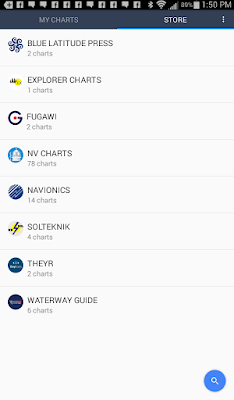
Charts can be purchased with in-app purchases directly in the app. This is easier than using the xTraverse site that the iOS app has to use. Purchased charts are good for up to two devices.
Navionics Android Tablet charts can be purchased from $69.00-$89.00 per region. Navionics Charts for your Android smartphone will cost $29.00 to $59.00 per region. Other chart types from Explorer, Delius Klasing, Fugawi, Canadian CHS, Blue Latitude, NV Charts, Theyr Weather, Waterway Guides, Trak Maps and Solteknik can also be purchased.
I download the app on my Samsung Galaxy tablet with no problem. I am not sure if there is a list of compatible devices. The Google Play store should tell you if it is compatible with your device.
Chart updates are free for one year then the charts must be purchased again for continued updates. If you download them all to your device you can maintain that copy. The chart purchases include one free month of iNavX Pro. All charts can then be activated and downloaded to the iNavX app on your device for offline viewing.
Waypoints:
Waypoints are the building blocks of navigation and the routing function within the app. In iNavX there are two ways to create waypoints.
The first is to simply tap the chart screen once where you want to place a waypoint. A banner at the bottom of the screen will open up with options of New Route, Add Route ad GoTo. On the upper right corner of the banner you will see a pencil icon. Tap this to pen up the edit the waypoint's name and icon or color.
If you want to move a waypoint simply tap the waypoint icon on the map and move it around around to where you want it. I found the waypoint icons too small and very hard to tap and move around to where I wanted. Bigger waypoint icons would be a plus.
The second way to create a waypoint is with the Waypoint menu selection on the bottom of the screen. Tapping this brings up your list of waypoints. Tap the blue + plus sign in the lower right to add a new waypoint. You can then edit the name, coordinates, icon color and the description of the waypoint. Swipe left on any waypoint to Hide, Go To and Delete.
 Routes:
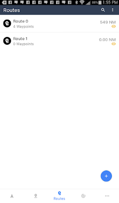
A route is simply a collection of waypoints that make up the path to your destination. To create a route select the Routes soft key at the bottom of the main Chart display.
On the route display you will see a blue + sign in the bottom right hand corner. Selecting this will add a route and take you into the route creation and editing page. The new route will be given an name like Route 0.
You can change the name of your route by tapping the pencil icon in the upper right corner to rename the route. The three vertical dots will allow Go To, Scroll To, Duplicate, Invert, Open With and Delete.
Once a route is selected waypoints can then be added with the blue icon in the lower right corner. This requires that you created waypoints in the previous waypoints section.
Tracks:
Tracks are simply a digital recording of the path that your vessel has taken as it travels through the water over time.
The iOS version of iNavX keeps track records for up to the last 500 miles traveled. I am not sure what the limitation is for the Android version.
To start Tracking select the Track soft key at the bottom of the main navigation display. Start tracking by tapping the red icon in the lower right corner of the display. The app will record your distance, average speed, and elapse time while tracking is enabled. Track points are recorded every 20 seconds. The Settings (gear icon) with the tracking function allows track back and 3 levels of tracking precision.
With a Track selected, selecting the export icon (three connected dots) allows download of your tracks to your X-Traverse account in a GPX or KML file formats. To remove your track logs simply swipe to the left on any of the recorded tracks.
Another neat feature is the Background Recording. Even with with the iNavX app suspended it will continue to record track information. Make sure to have your device plugged into power, if not, it will drain your battery rather quickly. This feature will only work with the devices Location services.
The last icon on the bottom of the screen will bring up selections for Account, Instruments, Tool & Forecasts, Settings and Help. Logging into your xTraverse account will allow you to store all of your waypoints, routes and tracks. You can upload these for storage and download them for use on other devices.
Instruments are a very powerful part of the iNavX app. Selecting this displays course over ground (COG), speed over ground (SOG), heading (HDG), rotation (ROT), altitude, connection type, location error, latitude, longitude and system time. If the app is connected with WiFi to your ships instruments additional data will be available.
Once navigating to a waypoint additional data including bearing to waypoint (BTW), distance to waypoint (DTW), velocity made good (VMG), anchor drift (AAD) and cross track error (XTE). Tapping on any of these instruments creates a full scree display of the value in digital form.
After working with the app for a while it seems to have pretty much all the functionality that the iOS version has. The iOS version had TCP/IP connectivity which I was not able to find on this Android version. The Google Play store says it is available with an in app purchase but I was not able to locate where to make the purchase. If anyone know, please let me know. I will keep looking. It may not be available until some charts are downloaded.
Give me some feedback on what you think of this version. I think it is a big win for iNavX and all of the Android user out there.
~~~ Sail On ~~~ /)
Mark


I loaded the app on my Galaxy Note 5 and was unable to see a heading vector while underway. The boat icon was jerking around and the lat/lon was not stable, even when at rest. Any thoughts?
ReplyDeleteI am not that familiar with Android devices, but I assume the Galaxy 5 has an internal GPS. If it does not it will be using a cell derived location that will not be as accurate.
ReplyDeleteThe velocity vector only shows when you are moving. You can change the color of the vector under settings on the Charts page.
The boat icon will change orientation as you move your device from different directions. Mine seems to work on the iOS version. Contact iNavx directly if you still have problems.
Good luck!
Mark
We Fix All maps device issues, Magellan GPS update, Garmin map update, Tomtom map update or any other maps device.
ReplyDeleteGarmin map updates
Magellan GPS update ,
7 ผลไม้นำโชค ในการ ปั่นสล็อต ผลไม้นับว่าเป็นอีกหนึ่งสิ่งที่มีความเชื่อเรื่องดวงเข้ามาเกี่ยวโยงอยู่ด้วย ผลไม้นับเป็นของมงคลอันบริสุทธิ์ เนื่องจากว่ามีเหตุ pg slot มาจากพลัง ธรรมชาติ
ReplyDeleteThis comment has been removed by a blog administrator.
ReplyDeleteThis comment has been removed by a blog administrator.
ReplyDeleteThis comment has been removed by a blog administrator.
ReplyDeleteThis comment has been removed by a blog administrator.
ReplyDeleteThis comment has been removed by a blog administrator.
ReplyDeleteThis comment has been removed by a blog administrator.
ReplyDeleteThis comment has been removed by a blog administrator.
ReplyDeleteThis comment has been removed by a blog administrator.
ReplyDeleteThis comment has been removed by a blog administrator.
ReplyDeleteThese navigation features are justwonderful
ReplyDeleteControl excess oil and combat breakouts with Bio Valley’s best facewash for oily and acne skin. Infused with natural ingredients, it deeply cleanses pores, removes impurities, and balances sebum production without over-drying. Its anti-bacterial and anti-inflammatory properties help prevent acne, soothe irritation, and leave your skin fresh, clear, and radiant. Experience a gentle yet effective skincare solution with Bio Valley – your ultimate choice for healthy, oil-free skin.
ReplyDelete