Blog Pages

Friday, November 25, 2011

AIS Radar

Application: iPhone, iPad
Function: AIS charting and information
Rating: **
Cost: $11.99


AIS can be used by the long distance cruiser or the weekend coastal boater to add a level of safety. AIS Radar is a reasonably priced app that will give you some basic AIS functionality.


AIS stands for Automatic Identification System.  Large international commercial ships and all passenger ships are required by law to broadcast AIS data to prevent collision and increase safety while at sea.  It is estimated that there are about 40,000 ships currently carry AIS class A equipment. The new Class B AIS standard was introduced in 2007 and created a new generation of low cost AIS transceivers.  AIS will not replace conventional radar but can be used to assist the yachtsman in collision avoidance.

AIS is becoming more popular with the advent of cheaper software and hardware. AIS uses VHF frequencies to broadcast and receive the AIS data and targets. AIS Radar can display data received from marine AIS transponders such as the ExNC 101 Class B AIS Transponder over a WiFi network. For AIS transponders or receivers without built-in WiFi support, an external serial WiFi adapter such as the SEAMate1A Lite, the Brookhouse iMux, the Roving Networks RN-370 or the Digi Connect® Wi-SP can be used.

Data from public AIS networks can optionally be displayed from the Internet.

Features:
  • Radar like display of AIS data and targets.
  • Course, heading and speed information of targets
  • Variable radar display range
  • Multiple symbols for AIS targets. Class A and class B transponders.
  • Computes CPA, closest point of approach and TCPA, time to closest point of approach.
  • Multitouch gestures to select display range
  • Display modes of heading up, course up and north up
  • Options to hide slow moving targets from radar display
  • List of AIS targets and display all information about the targets
  • Viewer for AIS safely related broadcast messages
Four soft keys, Radar, Targets, Messages and Settings are used to navigate within the app. The radar like display shows real time AIS targets. Targets are shown with different symbols depending on if they are AIS A or B. The app allows different radar ranges to be selected with multi touch gestures.

The Targets display gives you a list of AIS targets which can be selected to give more details. The name, call sign, type, status, speed, course and heading can all be viewed.

The price of app at $11.99 is reasonable if your just looking for a stand alone AIS app. The one draw back is that it does not display the targets on a marine chart. There are several charting apps that do also include AIS displays.  If you have the iNavx app the AIS display is integrated into the charting display.  I have a list of the Top 5 Best AIS apps listed on my blog. Check them all out and see which one fits your needs.

Saturday, November 19, 2011

Digital Yacht - iOnboard

Application: iPhone, iPad, iPod touch
Function: Marine data display
Rating: ***
Cost: $6.99

Digital Yacht has had quite a year with an introduction of many new electronics for the yachting enthusiast. They were just recently awarded the DAME 2011 NMEA award for marine electronics. The company creates devices that take your onboard navigation, instrumentation and AIS data and through WiFi makes this data available to mobile devices. The Digital Yacht WLN10 NMEA to wireless server the BOATraNet and iAIS systems provide these wireless data networks.

The iOnboard app is used on your iPhone or iPad to display the data from the wireless network. GPS data, instrumentation, navigation and AIS data are easily viewed when and where you want.  The iPad or iPhone are more mobile and less expensive than a full blown stand alone multifunction display.  Through a wireless TCP/IP link the data is transferred from the onboard server to your mobile device.

The app has four soft keys across the bottom. These access the GPS, navigation, instruments and settings pages.  The GPS page list the typical GPS coordinates, speed and course over ground, date and time. Additional pages show the list of GPS satellites and locations.


The navigation pages show course, heading and track displays to keep you on course. The instrument pages provide gauge like dials showing additional navigation instrument.

Digital Yacht also has another free app called Digital AIS.  This app displays AIS data on your mobile device from an onboard wireless AIS network.

The Automatic Identification System (AIS) is an automated tracking system used on ships and by Vessel Tracking Services for identifying and locating ships by electronically exchanging data with other nearby ships and VTS stations.

The Digital AIS app has a radar like display showing ships in your area and provides important information about the ships name, speed, course, heading and length.  AIS is valuable tool to keep track of possible collision courses with surrounding ship traffic. 

Both of these apps require that that you have onboard instrumentation networks and a WiFi network setup to broadcast the NMEA data. If all of your ships data is connected to your laptop you can set up an adhoc network to send this data to your mobile devices.  Digital Yacht has several WiFi devices that can be setup to create a WiFi network on your boat also.  There are many data display apps out there. The iOnboard app provides similar data to the NMEA Remote and MID+WiFi apps that I have reviewed. At $6.99 for the iPad version this is cheaper than the other two.  Take a good look at them all to see what fits your needs the best.

Thursday, November 17, 2011

Caribbean 1500

As fall approaches, sailors start thinking about the sunny skies and balmy trade winds of the Caribbean. This year 62 boats are heading south as part of the 22nd annual Caribbean 1500. 53 boats will sail the 1500 miles to the British Virgin Islands while 9 boats will finish in the Bahamas.

The Caribbean 1500 normally starts during the first week of November each year. This years rally was delayed by 5 days late due to tropical storm Sean but they are now closing in on the finish in the British Virgin Islands. Most boats make the trip in about 8-12 days.

The Caribbean 1500 is one of the longest running rallies for cruiser. It annually starts from Hampton Virginia and ends at Nanny Cay in the British Virgin Islands. Alternate routes can also be taken to Green Turtle Cay in the Bahamas. Boats of all shapes and sizes band together to train and sail together.

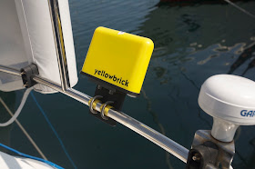
Many boats come in early and take in the seminars and training provided by the rally organizers. Mandatory safety seminars and inspections make sure the sailors are prepared for the trip. Many sailors return year after year to make the pilgrimage south.  Many new sailors join to sail with the seasoned group and experience safety in numbers. Daily weather forecasts are shared with all the cruisers and tracking of all the boats is done using the Yellowbrick satellite tracking system.

All the boats can be tracked on the World Cruising Club website which is now the home of the Caribbean 1500.
http://www.worldcruising.com/carib1500/viewer.aspx

If your ever heading south for the winter the Caribbean 1500 may be for you!

Friday, November 11, 2011

Volvo Ocean Race

I assume all you die hard sailors out there are following the Volvo Ocean Race. They are on day six of their race around the world.  All six boats left Alicante Spain and headed out into the Mediterranean Sea and eventually the Alantic Ocean on there way to Cape Town South Africa. Make sure to follow all the action on the official Volvo Ocean Race website http://www.volvooceanrace.com/en/home.html.

Two boats have already had mechanical problems and have dropped out of the first leg. Abu-Dhabi lost their mast and returned to Alicante for repairs. They restarted the race but decided to drop out of this leg again at this point. The will sail to Lisbon where they will pull the mast and get the boat on a freighter to Cape Town.

Sanya had problems with their hull separating after taking a beating in the Mediterranean Sea. They too have dropped out of the first leg. See the YouTube video of their damage. http://www.youtube.com/watch?v=g99Pdy-TGe4&feature=relmfu

More later!

Marine Instrument Display +WiFi

Application: iPhone, iPad iOS 4.3
Function: Instrument data display
Rating:***
Cost:$11.99 WiFi option, $3.99 no WiFi version


I am always looking for an inexpensive way to display data around the boat.  Hard wired multi-function displays are costly and difficult to wire and mount. Why not use your iPhone or iPad to display data where and when you need it. The folks at Veera Solutions has put together a nice little app called Marine Instrument Display+WiFi. There are two versions of this app the Marine Instrument Display only displays the devices GPS and compass data. MID+WiFi will displays all of the data listed below.

MID+WiFi can display position, speed and heading from your devices GPS, internal compass and locational services and many other variables if your onboard instruments are connected to WiFi.  MID+WiFi in WiFi mode can receive additonal NMEA0183 data over your ships WiFi network.  Using TCP/IP the data can be wirelessly sent to your device from an on board computer or WiFi multiplexer.

Features:
 Compass heading (mag/true) (HDG)
 Course over ground (COG)
 Speed over ground (SOG)
 Average SOG (ASOG)
 Maximum SOG (MSOG)
 Trip Distance (TRIP)
 Trip Time (TIME)
 Heeling (HLG)
 Position (POS)
* Apparent wind angle and speed (AWA, AWS)
* True wind angle and speed (TWA, TWS)
* Velocity made good (VMG)
* Boat speed (SPD)
* Depth (DPT)
* Sea temperature (SEA)
* Predicted Boat Speed (PSPD)
* Boat Speed to Predicted Boat Speed Ratio (SPR)
* = NMEA-WiFi bridge required

The app has the versatility to display three data pages with different font sizes. Three color modes for day and night are available (black/white, white/black, red/black)
Units can be changed to your desired preference kt / nm, mph / mi, km/h / km, m / ft, °C / °F

Selectable Data Fields
Selecting what data you want to display is as easy as tapping your finger on the screen. You can select the color mode by simply tapping on the value of any field to cycle through the color modes.  Just tap the title of any field to select the data to display.  The units can be set by tapping on the unit and cycling through the unit modes.

The angle of heel can be calibrated by tapping the unit degrees of the heeling (HLG). Value of any field can be reset by tapping and holding it for two seconds.

The different data pages can be reached by simply swiping left or right to reach the desired page. The app uses the locational services by default. This can be switched on or off by tapping the Position latitude and longitude coordinates. The WiFi mode is then enabled. You will have to supply the IP address and port in the settings screen. Just tap the POS indication do bring up the setting screen.

The application will run in the background mode for 30 minutes before turning off. Simply double tap the home button to kill the app.

The trip time only runs while moving which is calculated when the SOG is greater than zero.  The COG is only shown while moving and when the SOG is greater than zero.

I really liked the versatility of this app. It gives you complete control of what data you want to display and in what order.  The various pages give you options on how much data you want to display and in what sizes and units.  If your device has a GPS it will display the devices appropriate data. More data from your ships instruments can easily be added using the WiFi option from an on board computer or a WiFi multiplexer such as a Brookhouse iMux or similar device.

At $3.99 for the basic no WiFi and $11.99 for the WiFi version , the price is right for all the options supplied and the versatility of the app. I purchased it myself and look forward to using it while cruising and racing. NMEA Remote is a similar product but they charge $18.99 for their iPad version with similar functionality.