"BRINGING MORE GEEK TO YACHTING" WELCOME ABOARD! Reviewing the best iPhone and iPad marine navigation and GPS related applications.
Blog Pages
▼
Wednesday, December 25, 2013
Happy Holidays
Well I woke up early this morning to the sound of reindeer on the roof. Oh, maybe not, it could have just been the snow or ice crashing off the roof. I was hoping to sleep in this Christmas morning but being over 50 I can't sleep past 6:00 am anymore. If you are as old as I am you know what I mean. I flipped on the TV to watch the Disney parade and Facetimed with my brothers and sisters in Minnesota, Florida and Iowa. My brother in Florida reminded me it was going to be 80 degrees there today. Thanks brother, see you in a few weeks.
We had a great candle light service last night at church to celebrate the birth of Jesus. We are so fortunate to be around family and friends in this great community we live in. I want to thank my i-Marine Apps blogger family too for reading all the geeky stuff I write. I wish each of you a Merry Christmas and a Happy New Year! Each year is a blessing for me. I have a lot to be thankful for.
This year's Christmas picture finds my kids in college, my wife with a new job she loves and me having worked 30 years in the electrical power industry. It is time to leave 2013 in the rear view mirror. I am looking forward to all the new experiences and possibilities that await us in 2014.
~~~ Sail On ~~~ /)
Mark
Saturday, December 21, 2013
AquaMaps US HD
Application: Requires iOS 6.0 or later, iPhone, iPad, and iPod touch
Function: Nautical Marine Charting and tracking
Rating:**
Cost: $2.99
The Christmas season is upon us! Our kids are home from college and my wife has been busy preparing for the holidays. My job is to set up and decorate the Christmas tree. Right now our house is a mess with Christmas presents and decorations scattered everywhere. We only have a few days to pull it all together. No stress here! Luckily I woke up early this morning and found some quiet time to write a quick blog post about a new app you will want to take a look at.
Aqua Maps is the one of the latest apps to join the long list of marine charting apps. At this point it is a pretty basic app with chart display, waypoints, tracks and GPS tracking. I like what I see so far and I know the author has big plans to add additional features in the future.
Features:
The first thing you will want to do is download some charts for the area you want to view. The Chart download icon is located in the lower left of the screen. Tapping this will bring up a chart display with a grid overlay. Simply tap the tiles you want to download and tap the icon at the bottom to start the download process. You will want to be connected to WiFi at this point or it may take a while to download all the data. To remove the chart data from your device, go to settings and Reset the Downloaded Map option. You can now zoom in and display the detail for the area you downloaded.
The main display is very fresh looking with many markers and symbols. The color of the charts are very vibrant and clear. Depth gradients are shown with multiple colors to easily navigate shallow waters. Cities and towns are marked for easy location. The test size of the annotations seems too large and interferes with navigation at times. It might be nice to have a setting to make the text smaller or the option to turned it off all together.
There are a ton of symbols on the charts. Aqua Maps has more symbols than any other charting app that I have seen. A complete list of them can is seen here. The symbols appear at times to be too big in size and also interfere with navigation. Options to control the size of the symbols would be a welcome addition also.
The main display has several control features to run the app. The first two buttons are located in the upper left side of the screen. Tapping the top Crosshairs icon once will center the chart on your current position. Tap it again to enter the track up mode. Tap it again to go back to north up chart orientation mode.
The GPS icon below that is used to start and stop GPS tracking of your position. Once selected, a pop up box opens at the bottom center of the display. It will start recording your track on the display and provide Speed, Heading, Average speed, distance travelled and time travelled.
The track display box can be selected to bring up the Track edit feature. Here the user can edit the route name, color or delete the route. Additional information about the route is displayed including the date, time and trip information. You can share your route through the email option.
The Settings icon is in the lower right of the screen. Select this to access options for Chart overlays, Measuring units, Depth, Compass heading type and sounds. The chart overlay options lets you change the land background to a satellite view or a street map. This is handy to orientate yourself to city, street names and landmarks.
A handy Scaling icon on the center right of the screen allows zooming in and out of the display.
Tapping this in the center will bring up a Measuring tool which can be use to measure distances between to points on the chart. Simply place your finger on either end of the measuring line and drag them to the desired locations.
The distance will be displayed on one end of the line. A nice addition to this feature would be to also have the compass bearing of the line displayed also. By dragging one end of the line to your present position, the user can quickly make distance measurements and estimate the course to steer to a point on the chart.
The last icon on the screen in the upper right corner lists the chart data including Tracks and Markers.
Tap any of these markers or tracks to enter the edit mode. Here you can customize the marker points to a variety of colorful icons. Tapping the Checkered Flag on a marker will put you into the navigating mode to that waypoint marker.
Markers are easily added to any point on the chart by simply tapping and holding on a location. A pink star will be then added to that point.
Tap the Marker you just made for more options. Select the checkered flag to make it your destination or select the garbage can to delete it. Tapping the center will take you to the edit mode where you can select the customized icons.
The app is very intuitive and easy to use. The chart colors are vivid and the symbols seem to pop off the screen. All the features make sense and can be quickly accessed through the on screen icons and menus. With the addition of the few of the changes that I mentioned the app will become even more user friendly. I look forward to the next version of the app and expect the author will continue to build on the already very functional app.
Well, I hear my wife calling, I think she needs me to sample some of her cooking. I am the designated taste tester, lucky me. Wish me luck in making it through all the madness of the holidays. I want to thank you all for being my loyal follower and reading my blog. I hope in some small way I have helped you understand these amazing apps.
I hope you have a "HAPPY HOLIDAY SEASON" and wish you and your family the best in the new year!
~~~ Sail On ~~~ /)
Mark
Function: Nautical Marine Charting and tracking
Rating:**
Cost: $2.99
The Christmas season is upon us! Our kids are home from college and my wife has been busy preparing for the holidays. My job is to set up and decorate the Christmas tree. Right now our house is a mess with Christmas presents and decorations scattered everywhere. We only have a few days to pull it all together. No stress here! Luckily I woke up early this morning and found some quiet time to write a quick blog post about a new app you will want to take a look at.
Aqua Maps is the one of the latest apps to join the long list of marine charting apps. At this point it is a pretty basic app with chart display, waypoints, tracks and GPS tracking. I like what I see so far and I know the author has big plans to add additional features in the future.
Features:
- Offline Charts, satellite and Street hybrid views
- ENC Charts for US, Alaska, Hawaii and USACE Rivers, New Zealand, UK&Ireland, Germany and Rivers
- Netherlands, Belgium and Canals
- Center map button
- Spot sounding, Buoys, Beacons, Sea Floor information, Obstructions, Wrecks, Rocks, Dredges areas Fishing zones
- Download detailed map by tile
- On screen zoom controls or use pinch to zoom in
- Add, modify and delete customized Markers
- Display or no display of markers
- Import of KMZ and KML tracks and markers
- GPS Track recording
- Marker coordinates
- Sharing of markers, tracks and position through Air Drop, texting, Facebook and Email
- North Up and Track up orientation
- Track detail
- Custom track colors
- Distance measuring tool
- Speed, maximum and average
- Heading
- Moving time
- Distance
The first thing you will want to do is download some charts for the area you want to view. The Chart download icon is located in the lower left of the screen. Tapping this will bring up a chart display with a grid overlay. Simply tap the tiles you want to download and tap the icon at the bottom to start the download process. You will want to be connected to WiFi at this point or it may take a while to download all the data. To remove the chart data from your device, go to settings and Reset the Downloaded Map option. You can now zoom in and display the detail for the area you downloaded.
The main display is very fresh looking with many markers and symbols. The color of the charts are very vibrant and clear. Depth gradients are shown with multiple colors to easily navigate shallow waters. Cities and towns are marked for easy location. The test size of the annotations seems too large and interferes with navigation at times. It might be nice to have a setting to make the text smaller or the option to turned it off all together.
There are a ton of symbols on the charts. Aqua Maps has more symbols than any other charting app that I have seen. A complete list of them can is seen here. The symbols appear at times to be too big in size and also interfere with navigation. Options to control the size of the symbols would be a welcome addition also.
The main display has several control features to run the app. The first two buttons are located in the upper left side of the screen. Tapping the top Crosshairs icon once will center the chart on your current position. Tap it again to enter the track up mode. Tap it again to go back to north up chart orientation mode.
The GPS icon below that is used to start and stop GPS tracking of your position. Once selected, a pop up box opens at the bottom center of the display. It will start recording your track on the display and provide Speed, Heading, Average speed, distance travelled and time travelled.
The track display box can be selected to bring up the Track edit feature. Here the user can edit the route name, color or delete the route. Additional information about the route is displayed including the date, time and trip information. You can share your route through the email option.
The Settings icon is in the lower right of the screen. Select this to access options for Chart overlays, Measuring units, Depth, Compass heading type and sounds. The chart overlay options lets you change the land background to a satellite view or a street map. This is handy to orientate yourself to city, street names and landmarks.
A handy Scaling icon on the center right of the screen allows zooming in and out of the display.
Tapping this in the center will bring up a Measuring tool which can be use to measure distances between to points on the chart. Simply place your finger on either end of the measuring line and drag them to the desired locations.
The distance will be displayed on one end of the line. A nice addition to this feature would be to also have the compass bearing of the line displayed also. By dragging one end of the line to your present position, the user can quickly make distance measurements and estimate the course to steer to a point on the chart.
The last icon on the screen in the upper right corner lists the chart data including Tracks and Markers.
Tap any of these markers or tracks to enter the edit mode. Here you can customize the marker points to a variety of colorful icons. Tapping the Checkered Flag on a marker will put you into the navigating mode to that waypoint marker.
Markers are easily added to any point on the chart by simply tapping and holding on a location. A pink star will be then added to that point.
Tap the Marker you just made for more options. Select the checkered flag to make it your destination or select the garbage can to delete it. Tapping the center will take you to the edit mode where you can select the customized icons.
The app is very intuitive and easy to use. The chart colors are vivid and the symbols seem to pop off the screen. All the features make sense and can be quickly accessed through the on screen icons and menus. With the addition of the few of the changes that I mentioned the app will become even more user friendly. I look forward to the next version of the app and expect the author will continue to build on the already very functional app.
Well, I hear my wife calling, I think she needs me to sample some of her cooking. I am the designated taste tester, lucky me. Wish me luck in making it through all the madness of the holidays. I want to thank you all for being my loyal follower and reading my blog. I hope in some small way I have helped you understand these amazing apps.
I hope you have a "HAPPY HOLIDAY SEASON" and wish you and your family the best in the new year!
~~~ Sail On ~~~ /)
Mark
Thursday, November 28, 2013
ActiveCaptain Companion - On the Cutting Edge
Application: iOS iPhone, iPad, Mac, Android and PC
Function: Marine POI and Hazard warning guidance
Rating: *****
Cost: $Free
Jeffrey Siegel and his crew at ActiveCaptain have been helping boaters safely navigate and find points of interest(POI) on the worlds coastal regions for years now. I think I can safely say that the ActiveCaptain database is the world's largest, most complete list of marine points of interest. The unique thing is that the POIs, local knowledge and reviews are crowd sourced by people just like you and me. Jeff and his team confirm and verify every entry into the database so you can be assured the data is accurate.
The ActiveCaptain website is a great tool for locating marinas, restaurants, anchorages, fuel stops and hazards. It can be accessed through a standard web browser from your PC or Mac. If your looking for a mobile charting app that includes ActiveCaptain you don't have to look far. iOS apps including Garmin Blue Chart Mobile, SEAiq, PolarView, SailTimer, Skipper and Navimatics Charts and Tides provide the ActiveCaptain database of POIs. Android apps with ActiveCaptain include Jeppesen Plan2Nav, NutiCharts and SmartChart AIS. The ActiveCaptain folks offer incorporation of their database for free to anyone who wants to add it to their marine app or program.
The Active Captain Companion app was introduced recently and is now available for your iOS iPhone, iPad, Mac, Android devices and PC. The best part is that it is totally free. The whole idea behind the companion is to have a digital assistant watching out for you as you cruise the coastal regions of the world. The app is not meant to be used in place of your normal navigation practices but as an additional tool to help you safely navigate. The companion uses the extensive ActiveCaptain database and your GPS position to warn you of hazards and show other POIs that my be in your path. Hazards are the first to be implemented as warnings with other features to follow. Hazard warnings can be set up with an audible alarm or voice notification. Now you have a welcomed "back seat driver" that will keep you aware of the hazards around you on the water.
The app is not intended to be chart plotter but it does have some basic Streetmaps to show you the proximity of the markers. It is not a guide book although is does provide the complete list of ActiveCaptain points of interest for you to explore. The POI database is downloaded to your device so it can be used offline while you are away from the Internet or cell service. That's right, no Internet connection required.
Features:
1. Create Account. The first thing you will need to do is to create an ActiveCaptain account. This is free and can be done by simply providing an email and creating a password here on the ActiveCaptain website.
2. eBoatCard login. The next step is to login to the eBoatCards.com website. Use the same email and password that you used for your ActiveCaptain account. eBoatCards.com is the ActiveCaptain's social networking site for boaters. It allows members you to create group, post pictures, links, status updates, photos and blog if you like. Be sure to create your own electronic boatcard. This requires your boat name, hailing port, flag, name, model and time zone. Other information including captain, crew, boat details and use can also be filled out.
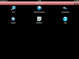
3. Download the ActiveCaptain Companion app from the iTunes store and tap the Star located in the lower right corner of the main display. This will bring up the Main Menu display. Select the ActiveCaptain Logo next to login to your account. Once logged in, download the database. This may take a few minutes so it is best done with a WiFi connection.
4. Download Detail Maps. The app comes with a base world map. More detailed maps can be downloaded with the Map/Tile Download selection in the Main Menu. Simply tap the tiles on the map where you want more detail and hit Tap here to Download at the bottom of the screen. These add finer detail but may still appear blurry if you zoom in too far. Remember that the app is not a chartplotter. The maps are just used for general reference.
5. Review Settings. The settings page provides options to select for the sound and voices, display, units, proximity hazards and GPS/NMEA settings. Review these to customize the display options.
Now that you have the app downloaded, your logged in and you have downloaded maps you are ready to put the companion to use.
The Main Menu also has a selection called Find. Tap this feature to locate a specific marker, GPS location by latitude and longitude or by US waterway mile maker.
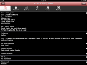
Once the item is found you can drill down into the selections for greater detail including name, address, phone, facility type, contact info, dockage, fuel, services and reviews. You can also add or modify your own reviews from within the app.
Each selection found has a Go
button next to it, tap this and it takes you to the map location. One thing I found annoying was that I had to re-type my search criteria in each time I went back to the Find page. I wish the app would keep my last search so I could keep reviewing the POIs in that area.
The main map view is shown in the upper portion of the display. The Plus and Minus controls on the right side of the screen allow the user to zoom in and out of the display. The pinch and spread features will not work for zooming.
Use your finger to Pan around the display map. Tap any point on the map to center it on that location. Tap any marker to center it in the Red cornered selection box. You can then select the POI to get additional details about each item.
Two large boxes are displayed across the bottom of the screen. The top Up Ahead line shows the Hazards that you will encounter on your current heading. Tapping the Up Ahead line will show a list of all upcoming hazards.
To the right of the Up Ahead list is a multi colored Overlay box. This allows customization of the display to filter the view of marinas, anchorages, hazard and local knowledge. Tap the box and check the options you want to display. The box will display open and grayed if the display is zoomed out too far. It will have an X in it if you have not logged into your ActiveCaptain account.
The Route Display is listed below the Up Ahead display line. It presently shows a compass because the GPS icon is not being followed. To follow your GPS position, tap the Return icon in the lower left of the screen. Tapping this will center the GPS icon on the screen and begin following it. The Route line should now show Proximity Mode. Proximity mode means the app is looking for hazards up ahead of your present location. To get out of Proximity Mode tap anywhere on the screen. There is no options to select the Route mode in this version. These capabilities may be added in a future release.
The compass bar can be used to change the orientation of the map. Simply tap and drag your finger left or right to change it. Double tapping the compass bar brings the orientation back to North Up.
ActiveCaptain is pushing the envelope with this new Companion app. They have created a new and totally novel approach to providing additional safety at sea. If your a coastal cruiser definitely download this app and add it to your smartphone, tablet, iPad or laptop. The next time you set out turn it on and be amazed and amused when it calmly warns you of upcoming hazards.
I know Jeff and his crew have many additional features planned for the Companion App. I would like to see a Gas Buddy like feature that would give me diesel fuel prices when I pull into an area. How about a list of top rated marinas or restaurants as I cruise the intercoastal? What features would you like to see?
Happy Thanksgiving Everyone! I hope you are surrounded by family and friends for this festive day. It is a time to truly give thanks for the abundant lives we have.
~~~ Sail On ~~~ /)
Mark
Function: Marine POI and Hazard warning guidance
Rating: *****
Cost: $Free
Jeffrey Siegel and his crew at ActiveCaptain have been helping boaters safely navigate and find points of interest(POI) on the worlds coastal regions for years now. I think I can safely say that the ActiveCaptain database is the world's largest, most complete list of marine points of interest. The unique thing is that the POIs, local knowledge and reviews are crowd sourced by people just like you and me. Jeff and his team confirm and verify every entry into the database so you can be assured the data is accurate.
The ActiveCaptain website is a great tool for locating marinas, restaurants, anchorages, fuel stops and hazards. It can be accessed through a standard web browser from your PC or Mac. If your looking for a mobile charting app that includes ActiveCaptain you don't have to look far. iOS apps including Garmin Blue Chart Mobile, SEAiq, PolarView, SailTimer, Skipper and Navimatics Charts and Tides provide the ActiveCaptain database of POIs. Android apps with ActiveCaptain include Jeppesen Plan2Nav, NutiCharts and SmartChart AIS. The ActiveCaptain folks offer incorporation of their database for free to anyone who wants to add it to their marine app or program.
The Active Captain Companion app was introduced recently and is now available for your iOS iPhone, iPad, Mac, Android devices and PC. The best part is that it is totally free. The whole idea behind the companion is to have a digital assistant watching out for you as you cruise the coastal regions of the world. The app is not meant to be used in place of your normal navigation practices but as an additional tool to help you safely navigate. The companion uses the extensive ActiveCaptain database and your GPS position to warn you of hazards and show other POIs that my be in your path. Hazards are the first to be implemented as warnings with other features to follow. Hazard warnings can be set up with an audible alarm or voice notification. Now you have a welcomed "back seat driver" that will keep you aware of the hazards around you on the water.
The app is not intended to be chart plotter but it does have some basic Streetmaps to show you the proximity of the markers. It is not a guide book although is does provide the complete list of ActiveCaptain points of interest for you to explore. The POI database is downloaded to your device so it can be used offline while you are away from the Internet or cell service. That's right, no Internet connection required.
Features:
- Audible alarm and male or female voice notifications
- Active Captain POI
- Marina
- Write Reviews
- GPS position following
- Anchorages
- Hazards
- Local Knowledge
- Pan and Zoom
- Search and Find POIs
- Map downloads
- GPS internal, local and remote configurations
1. Create Account. The first thing you will need to do is to create an ActiveCaptain account. This is free and can be done by simply providing an email and creating a password here on the ActiveCaptain website.
2. eBoatCard login. The next step is to login to the eBoatCards.com website. Use the same email and password that you used for your ActiveCaptain account. eBoatCards.com is the ActiveCaptain's social networking site for boaters. It allows members you to create group, post pictures, links, status updates, photos and blog if you like. Be sure to create your own electronic boatcard. This requires your boat name, hailing port, flag, name, model and time zone. Other information including captain, crew, boat details and use can also be filled out.
3. Download the ActiveCaptain Companion app from the iTunes store and tap the Star located in the lower right corner of the main display. This will bring up the Main Menu display. Select the ActiveCaptain Logo next to login to your account. Once logged in, download the database. This may take a few minutes so it is best done with a WiFi connection.
4. Download Detail Maps. The app comes with a base world map. More detailed maps can be downloaded with the Map/Tile Download selection in the Main Menu. Simply tap the tiles on the map where you want more detail and hit Tap here to Download at the bottom of the screen. These add finer detail but may still appear blurry if you zoom in too far. Remember that the app is not a chartplotter. The maps are just used for general reference.
5. Review Settings. The settings page provides options to select for the sound and voices, display, units, proximity hazards and GPS/NMEA settings. Review these to customize the display options.
Now that you have the app downloaded, your logged in and you have downloaded maps you are ready to put the companion to use.
The Main Menu also has a selection called Find. Tap this feature to locate a specific marker, GPS location by latitude and longitude or by US waterway mile maker.
Once the item is found you can drill down into the selections for greater detail including name, address, phone, facility type, contact info, dockage, fuel, services and reviews. You can also add or modify your own reviews from within the app.
Each selection found has a Go
button next to it, tap this and it takes you to the map location. One thing I found annoying was that I had to re-type my search criteria in each time I went back to the Find page. I wish the app would keep my last search so I could keep reviewing the POIs in that area.
The main map view is shown in the upper portion of the display. The Plus and Minus controls on the right side of the screen allow the user to zoom in and out of the display. The pinch and spread features will not work for zooming.
Use your finger to Pan around the display map. Tap any point on the map to center it on that location. Tap any marker to center it in the Red cornered selection box. You can then select the POI to get additional details about each item.
Two large boxes are displayed across the bottom of the screen. The top Up Ahead line shows the Hazards that you will encounter on your current heading. Tapping the Up Ahead line will show a list of all upcoming hazards.
To the right of the Up Ahead list is a multi colored Overlay box. This allows customization of the display to filter the view of marinas, anchorages, hazard and local knowledge. Tap the box and check the options you want to display. The box will display open and grayed if the display is zoomed out too far. It will have an X in it if you have not logged into your ActiveCaptain account.
The Route Display is listed below the Up Ahead display line. It presently shows a compass because the GPS icon is not being followed. To follow your GPS position, tap the Return icon in the lower left of the screen. Tapping this will center the GPS icon on the screen and begin following it. The Route line should now show Proximity Mode. Proximity mode means the app is looking for hazards up ahead of your present location. To get out of Proximity Mode tap anywhere on the screen. There is no options to select the Route mode in this version. These capabilities may be added in a future release.
The compass bar can be used to change the orientation of the map. Simply tap and drag your finger left or right to change it. Double tapping the compass bar brings the orientation back to North Up.
ActiveCaptain is pushing the envelope with this new Companion app. They have created a new and totally novel approach to providing additional safety at sea. If your a coastal cruiser definitely download this app and add it to your smartphone, tablet, iPad or laptop. The next time you set out turn it on and be amazed and amused when it calmly warns you of upcoming hazards.
I know Jeff and his crew have many additional features planned for the Companion App. I would like to see a Gas Buddy like feature that would give me diesel fuel prices when I pull into an area. How about a list of top rated marinas or restaurants as I cruise the intercoastal? What features would you like to see?
Happy Thanksgiving Everyone! I hope you are surrounded by family and friends for this festive day. It is a time to truly give thanks for the abundant lives we have.
~~~ Sail On ~~~ /)
Mark
Saturday, November 23, 2013
Navionics In App Purchases - Welcome or Nuisance!
Does anyone else feel like they are being nickel and dimed to death by Navionics these days? They have recently come out with several in app purchases for additional features for the app. When I buy an app I expect all of these features to be part of the app. I don't like the idea of having to keep paying once I purchase an app. I understand Navionics marketing philosophy on this. Let's sell them a base app and then offer all these other features to generate additional revenue.
I am usually a pretty positive guy, so I prefer to look at these additional features much like an ala carte menu. I am free to pick and choose only the features I want and don't pay for the ones I don't need. I guess no one is making me purchase these additional features. The base app will work without any of these additional bells and whistles.
I bought the Navionics USA HD app for my iPad a few years ago and have used it extensively. I paid a premium of $49.99 for the app. It is the most expensive apps I own. Then they started with the add on features which they make available through in app purchases.
First they added the Nav Module which should have been included in the original price. They charge $4.99 for this iPad upgrade. Next came Auto routing for $4.99, Advanced Map Options for $4.99, and last Navionics Plus for $24.99.
Lets take a look at each of these to see if they are worth the additional investment.
The Nav Module is one of the new features that is definitely worth the $4.99 price. It offers more advanced route planning with ETA, distance to arrival, heading to WP and fuel consumption.
A route can be created by tapping on the Route selection at the bottom of the chart. Use the crosshairs to create the starting point for your route. Additional intermediate waypoints can be added to a route by simply tapping the route segment. Routes have the option of being reversed. You can create up to 99 waypoints per route on the map and save up to 1000 routes.
Once you are on a route, hold your finger on a waypoint to adjust it's location. Indicators show you the present leg of the route, the time and distance to the end of the route. Additional route details on the information bar at left show your estimated time of arrival, distance to arrival, heading to waypoints and even fuel consumption.
Auto Routing is another in app purchase that will cost you an additional $4.99. It appears to me that you will need the Nav Module before this Auto routing feature will work. This is a new feature to help you quickly create routes with multiple waypoints automatically. It requires that you enter some boat data including draft into the app. Select your destination and with a tap on the map and it will chart your course. There are all kinds of disclaimers so I would be careful using this feature. Most of the time the route created will be less than optimal. The user will have to go in and edit each point manually to optimize the route.
As I see it, this feature is not really needed because you can quickly do this all by yourself in the Nav Module. Simply analyze the chart and place waypoints manually where you want them. Pay attention to depth, course and other possible obstructions while creating the course. I would rather create the route myself and not rely on the app to create it for me.
Advanced Map Options gives you even greater control of your map display. This upgrade will cost you $4.99 also. It adds additional controls to the Map Options page.
Selections include Highlight Shallow Area, select Depth Shading, filter Depth Contours, adjust shoreline to selected Water Level, view Seabed composition (select areas) and toggle Fishing Mode to locate key fishing areas.
If your a fisherman it may be worth it to have these additional features to show detailed depths. As a sailor of power boater, I do not see much advantage to having these features on the chart. Most of the time I am just concerned with channel marker and making sure I have enough depth beneath my keel.
Navionics+ is the latest offering of the in app purchases. This purchase will get you complete chart updates for a period of 12 months. This will be a reoccurring yearly fee if you want your charts up to date. Many apps provide free chart updates which is what many of us have come to expect. Navionics strays from this model and is now charging for updates year after year.
You also get their new SonarCharts. SonarCharts is an HD bathymetry chart that reflects up to date water depths and contours. SonarCharts is not currently available for Canada, South America, Greenland, West Africa, India, China, South East Asia and the Pacific Islands or the Bahamas. Again, I don't see the need or a benefit to view bottom detail and sea bed contour details. Not all areas are covered so check the Navionics website for details in your area.
I am usually a pretty positive guy, so I prefer to look at these additional features much like an ala carte menu. I am free to pick and choose only the features I want and don't pay for the ones I don't need. I guess no one is making me purchase these additional features. The base app will work without any of these additional bells and whistles.
I bought the Navionics USA HD app for my iPad a few years ago and have used it extensively. I paid a premium of $49.99 for the app. It is the most expensive apps I own. Then they started with the add on features which they make available through in app purchases.
First they added the Nav Module which should have been included in the original price. They charge $4.99 for this iPad upgrade. Next came Auto routing for $4.99, Advanced Map Options for $4.99, and last Navionics Plus for $24.99.
Lets take a look at each of these to see if they are worth the additional investment.
The Nav Module is one of the new features that is definitely worth the $4.99 price. It offers more advanced route planning with ETA, distance to arrival, heading to WP and fuel consumption.
In their quest for a better routing solution Navionic's introduced the Nav Module.
Nav Module was developed to enhance the route creation and trip information of the Navionics apps. It provides the user the ability to easily create routes consisting of multiple waypoints.A route can be created by tapping on the Route selection at the bottom of the chart. Use the crosshairs to create the starting point for your route. Additional intermediate waypoints can be added to a route by simply tapping the route segment. Routes have the option of being reversed. You can create up to 99 waypoints per route on the map and save up to 1000 routes.
Once you are on a route, hold your finger on a waypoint to adjust it's location. Indicators show you the present leg of the route, the time and distance to the end of the route. Additional route details on the information bar at left show your estimated time of arrival, distance to arrival, heading to waypoints and even fuel consumption.
Auto Routing is another in app purchase that will cost you an additional $4.99. It appears to me that you will need the Nav Module before this Auto routing feature will work. This is a new feature to help you quickly create routes with multiple waypoints automatically. It requires that you enter some boat data including draft into the app. Select your destination and with a tap on the map and it will chart your course. There are all kinds of disclaimers so I would be careful using this feature. Most of the time the route created will be less than optimal. The user will have to go in and edit each point manually to optimize the route.
As I see it, this feature is not really needed because you can quickly do this all by yourself in the Nav Module. Simply analyze the chart and place waypoints manually where you want them. Pay attention to depth, course and other possible obstructions while creating the course. I would rather create the route myself and not rely on the app to create it for me.
Advanced Map Options gives you even greater control of your map display. This upgrade will cost you $4.99 also. It adds additional controls to the Map Options page.
Selections include Highlight Shallow Area, select Depth Shading, filter Depth Contours, adjust shoreline to selected Water Level, view Seabed composition (select areas) and toggle Fishing Mode to locate key fishing areas.
If your a fisherman it may be worth it to have these additional features to show detailed depths. As a sailor of power boater, I do not see much advantage to having these features on the chart. Most of the time I am just concerned with channel marker and making sure I have enough depth beneath my keel.
Navionics+ is the latest offering of the in app purchases. This purchase will get you complete chart updates for a period of 12 months. This will be a reoccurring yearly fee if you want your charts up to date. Many apps provide free chart updates which is what many of us have come to expect. Navionics strays from this model and is now charging for updates year after year.
You also get their new SonarCharts. SonarCharts is an HD bathymetry chart that reflects up to date water depths and contours. SonarCharts is not currently available for Canada, South America, Greenland, West Africa, India, China, South East Asia and the Pacific Islands or the Bahamas. Again, I don't see the need or a benefit to view bottom detail and sea bed contour details. Not all areas are covered so check the Navionics website for details in your area.
All Navionic's users can contribute to the updates of the Sonarcharts. Anyone with a sonar device can record marine depth data and upload the data to the navionics.com website. The revised charts are then available within 24 hours.
This whole process of crowd sourcing data seems like a great idea. It does however cause me some concern. How do we know the data being recorded is right? Someone with an inaccurate depth sounder might be off several feet causing the rest of us to run aground using the updated chart. I am sure Navionics has a process to verify the submitted data before it updates the chart. Crowd sourcing data is a great idea as long as the data is vetted for accuracy before use.
Navionics is one of the leaders in the marine industry and continues to provide innovative solutions to charting like the Navionics HD charting app. Let me know if you are using any of these in app purchases and what your experiences have been. I would love hear from you!
~~~ Sail On ~~~ /)
Mark
Monday, November 11, 2013
NV Charts
Application: iPad, iPhone, iPod Touch iOS 6.1 or later, Android and PC
Function: Marine GPS charting and navigation
Rating:***
Cost: Free app, charts regions $10 to $179
NVCharts has been around for about 25 years providing paper chart kits for several areas in Europe and most recently the US and Caribbean waters. They are known for their waterproof chart sets but also provide electronic charts for you chart plotter, PC and mobile devices. With one purchase you get charts for all your devices plus a backup set of paper charts.
The NVCharts blog will help keep you up to date on the changes and additions to the app. The app is available for iOS, Android and Windows 8 users. If you buy a chart set the license allows you to use it across all platforms at no additional charge.
Features:
- Offline navigation
- Accesses all NV charts
- Simple purchase and download of charts
- Data is always up-to-date
- Synchronized navigation with all mobile devices
- Seamless Charts
- Zoom and panning functions
- Waypoint Markers and notes
- Range and Bearing Measuring Tool
- Routes
- Intuitive route planning
- Tracking
- Logbook
- Positioning with both GPS and cellular signals
- Lighthouse sketches
- GPS and navigation instruments
The NVChart's main screen shows your position along with latitude, longitude and time on a base map overlay. The menu is displayed across the bottom right of the screen. The menu includes Settings, Charts, Log, Ruler, Marker and Route. The menu can be turned on or off by toggling the wrench icon in the lower right.
Just above the menu is a blue ship icon. Select this to start navigation and the display of the instruments at the top of the screen. The instruments include GPS accuracy, latitude, longitude, course over ground, speed over ground, bearing, range, distance, ETE, ETA
Charts
Select the Charts icon at the bottom of the screen to buy and load charts. Selecting the Buy Charts icon will take you to the NVCharts website where you can shop for and purchase charts. You will have to create an account and login. Charts can be purchased with several options. You can just purchase the electronic charts for the NVCharts app. This is the cheapest option with many of the US charts regions listed at $10 per region and Bahamas regions at $49. You can also purchase charts for your mobile device and along with a hard copy set. This option is more expensive with chart regions costing about $69.80 plus shipping.
Once you have made your purchase the charts will need to be downloaded to your mobile device. Select the Load Charts icon where you will be prompted for your16 digit product code. Select your chart kit and download the charts. The download process will be faster if you are connected to WiFi for the download process.
Routes
The app has a very functional way to create waypoints and routes. To create a route select the Route icon from the menu. Select the New icon and note the new route line on the chart. Place your finger on one end of the route line to move it to your starting point and then move the other end to your destination.
Intermediate waypoints can be added by tapping the route line between waypoints. Tap any waypoint to move it or delete it with the menu selections. Other route options include Reverse, Activate and Add notes where the route details can be added and the route name can be modified. Additional routes can be created and displayed at the same time on the charts. The chart may get a little busy if you have a lot of routes in one area. It would be nice to have the option to display just the active route.
Ruler
Select the Ruler icon to measure distance between two points on the chart. Once selected note the information display on the top of the screen. Distance, bearing, duration, latitude and longitude are dynamically displayed. Place your finger on either point to move the starting or ending points of the bearing tool.
More than one measurement can be used and displayed on the chart. Select the new option to add another distance and bearing measurement. Each measurement can be saved with a unique name under the Notes selection. The Lock feature prevents the measurements from being moved or deleted.
Marker
The Marker tool works very similar and has many of the same features as the Route tool. Select add to create a new Marker. Other options include Activate, Delete, Notes and Lock. Markers are saved separate from the route waypoints. I am not sure why the author chose to call these points Markers. These markers should be called waypoints and all waypoints should be able to be included in creating a route.
I appears that all the markers that are created are displayed on the screen. If you create many markers in one area it may become congested and hinder proper navigation. I would prefer an option to display or not to display individual waypoints.
Settings
The settings are very basic with options for language, speed, distance depth, coordinates and compass orientation.
There are some additional settings options in the cruise mode. Select the red and white buoy in the upper right corner of the display to enter cruise mode. You will notice that the instrument display shows up in the top of the display. Select the setting option from the menu to change the boats name, cruising speed, draft, compass orientation, tracking and track lengths. Tracking is started and stopped with the follow menu selection at the bottom of the screen.
Another nice feature that has been incorporated is a logging function. It is very basic and allows you to enter the name of the log enter and some notes.
NV Charts has done a good job with their introductory iOS app. As an added bonus the app is available for your Android mobile device and your PC too. It provides some of the basic features that a charting app needs but falls short of being a real contender for i-Marine Apps Top 10 Charting apps. The app is new so I expect to see some additional updates and features added in the months to come.
~~~ Sail On ~~~ /)
Mark
Saturday, November 2, 2013
Anchor Alarm
Application: iPhone, iPad
Function: Marine Anchor Alarm
Rating:***
Cost: $1.99
Features:
Function: Marine Anchor Alarm
Rating:***
Cost: $1.99
One of my greatest fears as a sailor is dragging at anchor during the night and not waking up until it is too late. That is probably why most captains sleep with one eye open. The advent of apps for the iPhone and iPad have made it even easier to quickly set an anchor alarm and get a good night sleep.
I have looked at several anchor alarm apps over the years. This Anchor Alarm is unique in that it has an easy graphical way to set the anchor position and alarm distances. I even lets you move the anchor position and alarm distance if needed.
Features:
- Easy to set anchor position
- Set position at your current location
- Choose a position on the map or relocate anchor with drag and drop
- Navigate with standard map gestures (zoom, scroll ...)
- Works without an Internet connection. Once offline the map is replaced by a graphic.
- Three alarms methods
- Attention catching visual alarm with a blinking black/white screen,
- Audible alarm
- Operates in background mode, acoustic alarm with a notification.
- Adjust alarm distance in settings or graphically on the map
- Enhanced track recording with colored path displayed on a map
Main Display:
The main display has five soft keys at the bottom of the screen. The first Warning icon brings up a disclaimer page pointing out that this is only a tool for sailors and should not be solely relied upon for safety concerns.
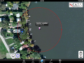
The second Anchor icon allows you to set the anchor alarm while dropping the anchor. This should be done at the bow of the boat while setting the anchor. The closer you set the alarm to the actual anchor position will give you a more accurate position reading on the display.
The Map icon displays a satellite map of your position and the anchor position. Manual settings for the app are made on this page including alarm distance, alarms type, alarm sounds, map type, tracking, position and monitoring features.
To set the anchor, tap the drop anchor icon in the bottom right of the screen. The anchor position default is set at your GPS location. To move the anchor position, place your figure on the anchor and move it to the desired anchor location. A red circle show the alarm distance. If your boat moves outside of this circle the alarm will sound. To move the circle, place your finger on the circle and move it towards or away from your anchor position.
Alarms can be set with the icons in the top right of the display. Select an email, visual or audible alarm. Map orientation can be selected with the orientation center in the lower left side of the map screen. Select between north up, course up, or center the map on your boat or the anchor position selected.
Settings:
The Setting icon has options to set the alarm distance, change metric or English units, set the anchor position and enable alarm types. The app provides three map types including satellite, map and hybrid options.
The tracking feature can also be enabled here. The app will track your position as you swing on your anchor. This is helpful to re-adjust your anchor position and alarm distance if you are getting false alarms.
Tracks can easily be exported in an email in the .GPX and .CSV file format types.
Another option in the setting menu that is listed as experimental is the Remote Mode. This works in coordination with the Find My iPhone app and allows you to track the phones location and your boat as long as it has a GPS and Internet connection.
Help Page:
The app has an extensive Help screen which can be selected by the last icon in the menu at the bottom right side of the screen. It is nice to have a help screen to explain all the features. All the features are detailed along with graphics where needed.
Many programmers are good at coding but most are very poor at documenting how their app actually works.
Most chart plotter these days have built in anchor alarms, so you may ask yourself, why do I need an app to do this also. Well most of us can't take our chart plotter to bed with us. The iPhone or iPad can be placed close at hand near your berth when you turn it and notify you if needed. It never hurts to have a back up also.
The Anchor Alarm app will cost you a couple bucks but it is well work every penny for the peace of mind you will have knowing it is monitoring your position while you sleep. A good night sleep at anchor is priceless.
~~~ Sail On ~~~ /)
Mark
Saturday, October 12, 2013
Digital Yacht Launches Three New Products
Well, fall is in the air here in the Midwest. The leaves are turning magnificent colors and reminding me that winter is not far away. The sailboat is still in the water but I fear my days are numbered. Fall sailing has been great. The steady winds and cool days make it a great time to get out on the water.
This week I am writing about some new and exciting hardware introduced to the marine market. If you are a regular reader of my blog you know i-Marine Apps is dedicated to finding and reviewing marine apps. However, when some new geeky hardware comes out I can't resist and have to take a look. New electronics hardware is being designed and built at such a rapid pace these days it is tough to keep up on the latest developments.
Digital Yacht is a UK based company that specializes in marine AIS receiver and transponders, WiFi Internet devices, GPS sensors and NMEA electronics technology. They just announced this week an introduction of three new pieces of technology you will want to take a look at.
The GPS DualNav 150 is a completely new GPS sensor which incorporates multiple GPS sensor options. Most of us are familiar with the US military based GPS system that was made available to the general public back in the 1990s. This worldwide system of satellites is relied upon and widely used in the marine industry today. In recent years GPS has become mainstream and almost everyone now has a GPS receiver in their smart phone.
This sensor is unique because it also includes the ability to receive the Russian based GPS system, GLONASS. Being able to use both of these systems provides an optional backup to the present system. Having two system also makes this sensor more sensitive, accurate and reliable.
The sensor will also be able to use a third European Galileo system when that comes online in 2018.
The sensor will switch automatically between the three systems to provide the best results. It also has the option to be switched manually to select the best system for your area.
The GPS 150 can be connected to the WLN10 wireless interface to allow your mobile devices, including iPhones and iPads, to receive GPS data. The unit has a USB interface also for easy connection to a PC or MAC computer.
Features:
- 50 Channel GPS, GLONASS sensor
- Auto or manual source selection is configurable with dip switches
- NMEA 4800, 38400 and 115,200 baud rates
- Update rates of 1-10Hz
- Turbo Nav mode for fast data updates
- WAAS, EGNOS and SBAS enabled for 1 meter accuracy
- 30 mA power consumption at 12 volts
- 5-30 volt power source
The GV30 is a combination AIS/VHF and GPS antenna for use with Class B transponders.
AIS or automatic identification systems are required on all commercial vessels over 300 tons and all passenger vessels regardless of size. Many private vessels are also installing AIS systems to provide information about surrounding ship traffic. Boaters can feel safer and make better decisions knowing what surrounding vessels are doing.
AIS provides situational awareness to captains so they can quickly determine what vessels are in the area, what course and speed they are on and if they are on a collision course.
The GV30 is unique in that it has a GPS receiver combined with the VHF/AIS receiver. The unit provides a dedicated GPS source specifically tuned to 162MHz for your AIS receiver.
Features:
- Combination AIS/VHF and GPS antenna
- Specifically tuned to 162 MHz
- High gain GPS
- 2X10 Meter cables with mini connectors
- Standard 1 inch threaded base mount
- TNC and BNC adapters
The S1000 is a self contained battery powered SART (Search and Rescue transponder). Recent legislation has now made these devices compliant for use on vessel over 300 tons.
Once activated, the S1000 will provide the identity of the party in distress and give regular 4 minute updates of the GPS position that can graphically be displayed on any Class A or B transponder system or AIS receiver.
This device can greatly aid in a man overboard situation or in recovery of a life raft by rescue personnel. Specialized VHF technology helps provide a range up to 10 miles. Once activated it will continue to send AIS and position data up to 96 hours.
Features:
- 10 NM range
- 1 meter telescoping antenna
- 96 hour battery life
- Data transmitted every 4 minutes
- Integrated 50 channel GPS receiver
- Fully IMO compliant
- LED indications for test and activation
- Low battery consumption
- Storage pack and bracket
Technology continues to provide boaters with additional safety hardware. AIS, SART and GPS are all helping us to be safer and hopefully better captains on the water. Just remember that all the electronics in the world will not prevent you from having an accident. Your own eyes and ears are still the best way to stay out of trouble so, pay attention while on the water. Don't be distracted by all your gadgets, pay attention to your surroundings and use them only as aids in your navigation.
~~~ Sail On ~~~ /)
Mark
Saturday, October 5, 2013
GPS Nautical Charts USA
Application: iPhone, iPad
Function: Marine navigation, charting, routing and tracking
Rating:***
Cost: $14.99
About a year ago I reviewed GPS Nautical Charts for Android app, and was pleasantly surprised. It was a welcomed addition to the Android charting family of apps. Recently the iPhone and iPad versions were released so I thought it was worth another look to see what the iOS version had to offer.
The app uses NOAA raster charts. These are the scanned versions of the paper charts that are used by many of the iPhone and iPad apps. The app displays the charts nicely with several zoom levels.
It does however only let you view one chart at a time. The features list says that the charts are quilted, however I was not able to go from one chart to another seamlessly.
The main navigation around the app is by a menu system at the bottom of the display. Various tabs can be selected to create and display waypoints, routes, list nearby charts, record tracks and view points of interest.
Other controls on the main page include the My Charts button in the upper left and a GPS position icon in the upper right. The My Charts icon lets you select and download the charts for viewing. The GPS position icon in the upper right of the chart screen moves the chart to your current position.
Features:
The USA version include access to the NOAA coastal charts, the Great Lakes, Alaska, Hawaii, Puerto Rico, US Virgin Islands, USACE inland lakes, some freshwater lake in various US states. All of these charts provide a very extensive coverage of the US water. Other versions are available for the Caribbean, Croatia, Canada, Iceland, Oman, Malta, Estonia, South Africa, Brazil, Argentina, Germany, Spain, Portugal, Netherlands and Belgium.
Charts can be selected for download in several different ways. From the Map display, select the My Charts icon in the top left of the display. Next select Add Charts+. The handy Search Charts option allow a text search of a specific area or region. The Chart Catalog lists the charts by State, Region, Coast Guard District and US Army Corp Of Engineers Inland Rivers. Finally the Visual Download/Select Area shown above, lets you define a region of a map and then download all the charts in that region.
Waypoints
Waypoints can be created with the New Waypoint selection located in the on screen menu at the bottom of the chart display. Selecting this option provides three ways to create a new waypoint. Selecting Current Location via GPS creates a waypoint at your current GPS location. Simply provide a name for the point and hit the locate button in the lower left of the screen to automatically fill in the latitude, longitude and altitude.
The app also lets you create a waypoint by selecting the Enter Lat and Lon Manually option. Simply fill in the name, latitude and longitude coordinates of the waypoint and select Save. The third way to create a waypoint is by placing the crosshairs of the map display on the point where you want the waypoint. The latitude and longitude are filled in automatically. Simply provide a name for the waypoint and select Save at the bottom of the screen.
Waypoints can then be displayed by selecting the View Waypoints selection from the menu. Waypoint show up at small black circles with a white center. All waypoints are displayed but only the selected waypoint's name is shown. Select the Clear menu option to clear all the waypoints from the screen.
Routes
Routing is a key feature of a functional marine app. Routes are created by selecting the New Route icon in the main menu at the bottom of the screen.
The Route menu will then be displayed at the top of the screen. Select the center route creation icon and tap the blue New Point at the desired location to create the next point in your route.
Select the floppy disc icon to save and name the route.
The Route Manager provides options to Play, View, Follow, Export and view Statistics of your route. Export of a Routes is done through email in a .gpx format.
Points of Interest
The app provides a extensive list of points of interest data listed on the charts. They include Lights, beacons, bridges, cables, coast guard stations, caution areas, land marks, rivers, piles, wrecks etc.
POIs can be found by the Search POIs or the View POIs menu options. The POIs are however limited to the chart data so it won't help you find restaurants, bars, stores or other marine services.
POIs can be displayed on the chart by selecting one from the list. To stop display of the POIs data simply select the Clear menu option.
Auto Follow and Record
The Auto Follow feature will display your current GPS position on the chart as you move. The boats GPS heading and speed over ground are displayed on the bottom left of the display for reference. Selecting the Rec, record button on the menu starts recording the boats track. Tap these menu options again to stop the recording and following features.
Distance and Bearing
A distance and bearing feature is also provided in the main menu. Tapping this feature displays a range and bearing display on the chart. This feature can quickly provide navigation data to a light or harbor entrance. The center of the range is taken from the crosshairs maker on the chart.
The distance and bearing measurement data are shown at the top of the chart display. These can be set to display in kilometers, miles or nautical miles in the options menu. Select Clear to remove the range and bearing marker.
Tides & Currents
Tidal and current data is important information to have if your in a region with extreme fluctuations in sea level. The GPS Nautical app only provides a basic tabular display for data in the US, United Kingdom, the Pacific, Caribbean and Germany. It allows you to save any of the stations as a favorite for quick retrieval.
Voice prompts
I have reviewed many marine apps but have never heard of any with voice prompts. GPS Nautical has incorporated voice prompts and warnings for such things as alerts if your boat is off course, going the wrong direction or when your approaching a route marker.
Continuous distance and estimate time of arrival updates also keep the boater up to date on their progress while navigating.
The iOS version of GPS Nautical is equally impressive. It has many features that make it a very usable marine navigation app. The main menu allows you to access many of the features on the chart screen. I found myself having to use the Back button many time to get back out of some of the menu settings and options. This was a little annoying and could be improved on.
Navigating around the charts was easy and incorporated many of the iOS gestures and controls. Compared to other apps with similar features, the price might be a little high at $14.99. If your looking for a basic NOAA chart viewer with some GPS tracking, waypoint and routing features this is worth a look..
~~~ Sail ON ~~~ /)
Mark
Function: Marine navigation, charting, routing and tracking
Rating:***
Cost: $14.99
About a year ago I reviewed GPS Nautical Charts for Android app, and was pleasantly surprised. It was a welcomed addition to the Android charting family of apps. Recently the iPhone and iPad versions were released so I thought it was worth another look to see what the iOS version had to offer.
The app uses NOAA raster charts. These are the scanned versions of the paper charts that are used by many of the iPhone and iPad apps. The app displays the charts nicely with several zoom levels.
It does however only let you view one chart at a time. The features list says that the charts are quilted, however I was not able to go from one chart to another seamlessly.
The main navigation around the app is by a menu system at the bottom of the display. Various tabs can be selected to create and display waypoints, routes, list nearby charts, record tracks and view points of interest.
Other controls on the main page include the My Charts button in the upper left and a GPS position icon in the upper right. The My Charts icon lets you select and download the charts for viewing. The GPS position icon in the upper right of the chart screen moves the chart to your current position.
Features:
- Voice Prompts for marine navigation (requires GPS )
- 1ft / 3ft depth contour maps for anglers for selected lake maps
- Supports GPX/KML route editing/import
- Displays Tide & Currents prediction
- Seamless chart quilting of marine charts
- Enter way points
- Record tracks, Auto follow with real time track overlay
- Search POIs, buoy, lights, harbor facilities, Obstr. etc)
- Voice Prompts for marine navigation
- Route Editing/Creation
- Offline NOAA charts
- Tide & Currents
- Distance Bearing tool
- Create custom way points
- POI layer for marine charts
- Pan/Zoom/My Location
- Record and view GPS tracks
- Live track animation
- Track analytics/stats
- Export GPX tracks to share
- Auto Follow Mode (Course up)
The USA version include access to the NOAA coastal charts, the Great Lakes, Alaska, Hawaii, Puerto Rico, US Virgin Islands, USACE inland lakes, some freshwater lake in various US states. All of these charts provide a very extensive coverage of the US water. Other versions are available for the Caribbean, Croatia, Canada, Iceland, Oman, Malta, Estonia, South Africa, Brazil, Argentina, Germany, Spain, Portugal, Netherlands and Belgium.
Charts can be selected for download in several different ways. From the Map display, select the My Charts icon in the top left of the display. Next select Add Charts+. The handy Search Charts option allow a text search of a specific area or region. The Chart Catalog lists the charts by State, Region, Coast Guard District and US Army Corp Of Engineers Inland Rivers. Finally the Visual Download/Select Area shown above, lets you define a region of a map and then download all the charts in that region.
Waypoints
Waypoints can be created with the New Waypoint selection located in the on screen menu at the bottom of the chart display. Selecting this option provides three ways to create a new waypoint. Selecting Current Location via GPS creates a waypoint at your current GPS location. Simply provide a name for the point and hit the locate button in the lower left of the screen to automatically fill in the latitude, longitude and altitude.
The app also lets you create a waypoint by selecting the Enter Lat and Lon Manually option. Simply fill in the name, latitude and longitude coordinates of the waypoint and select Save. The third way to create a waypoint is by placing the crosshairs of the map display on the point where you want the waypoint. The latitude and longitude are filled in automatically. Simply provide a name for the waypoint and select Save at the bottom of the screen.
Waypoints can then be displayed by selecting the View Waypoints selection from the menu. Waypoint show up at small black circles with a white center. All waypoints are displayed but only the selected waypoint's name is shown. Select the Clear menu option to clear all the waypoints from the screen.
Routes
Routing is a key feature of a functional marine app. Routes are created by selecting the New Route icon in the main menu at the bottom of the screen.
The Route menu will then be displayed at the top of the screen. Select the center route creation icon and tap the blue New Point at the desired location to create the next point in your route.
Select the floppy disc icon to save and name the route.
The Route Manager provides options to Play, View, Follow, Export and view Statistics of your route. Export of a Routes is done through email in a .gpx format.
Points of Interest
The app provides a extensive list of points of interest data listed on the charts. They include Lights, beacons, bridges, cables, coast guard stations, caution areas, land marks, rivers, piles, wrecks etc.
POIs can be found by the Search POIs or the View POIs menu options. The POIs are however limited to the chart data so it won't help you find restaurants, bars, stores or other marine services.
POIs can be displayed on the chart by selecting one from the list. To stop display of the POIs data simply select the Clear menu option.
Auto Follow and Record
The Auto Follow feature will display your current GPS position on the chart as you move. The boats GPS heading and speed over ground are displayed on the bottom left of the display for reference. Selecting the Rec, record button on the menu starts recording the boats track. Tap these menu options again to stop the recording and following features.
Distance and Bearing
A distance and bearing feature is also provided in the main menu. Tapping this feature displays a range and bearing display on the chart. This feature can quickly provide navigation data to a light or harbor entrance. The center of the range is taken from the crosshairs maker on the chart.
The distance and bearing measurement data are shown at the top of the chart display. These can be set to display in kilometers, miles or nautical miles in the options menu. Select Clear to remove the range and bearing marker.
Tides & Currents
Tidal and current data is important information to have if your in a region with extreme fluctuations in sea level. The GPS Nautical app only provides a basic tabular display for data in the US, United Kingdom, the Pacific, Caribbean and Germany. It allows you to save any of the stations as a favorite for quick retrieval.
Voice prompts
I have reviewed many marine apps but have never heard of any with voice prompts. GPS Nautical has incorporated voice prompts and warnings for such things as alerts if your boat is off course, going the wrong direction or when your approaching a route marker.
Continuous distance and estimate time of arrival updates also keep the boater up to date on their progress while navigating.
The iOS version of GPS Nautical is equally impressive. It has many features that make it a very usable marine navigation app. The main menu allows you to access many of the features on the chart screen. I found myself having to use the Back button many time to get back out of some of the menu settings and options. This was a little annoying and could be improved on.
Navigating around the charts was easy and incorporated many of the iOS gestures and controls. Compared to other apps with similar features, the price might be a little high at $14.99. If your looking for a basic NOAA chart viewer with some GPS tracking, waypoint and routing features this is worth a look..
~~~ Sail ON ~~~ /)
Mark
Saturday, September 14, 2013
Boat Watch
Application: iPhone, iPad, iPod Touch iOS 6.1
Function: AIS vessel tracking and details
Rating:****
Cost: Free, $2.99 in app purchase for boat details
Boat Watch is another great app developed by the Electric Pocket Ltd. group. Steve Bennet and his company have developed other great apps including, SeaNav, Boat Beacon and Compass Eye. I have reviewed all of these apps in this blog over the last few years. I guess I have been giving them so much press because they create some pretty cool and useful apps for mariners!
Features:
AIS stands for Automatic Identification System. Large ocean going vessels are required to broadcast AIS data for collision prevention purposes. Many recreational vessels are also installing AIS so they can see ship traffic and be seen by other larger vessels.
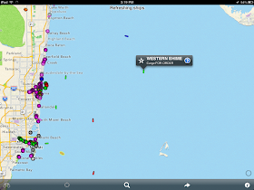
The app has a menu bar across the bottom. The Binoculars icon on the far left is used to keep track of your favorite vessel. To mark a favorite select a ship and tap the star located to the left of the vessel name. The Location icon, second from the left brings your current GPS position to the center of the map. The Search icon allows a search for a specific ships name, MMSI or location. The Arrow icon creates an email or text with a link to the Boat Watch app. The last Info icon on the right contains settings for units, maps and vessel display options. The display can be change between a map, satellite or a hybrid display.
At first look, I thought the Boat Watch app was not that much different than the Boat Beacon app. While it has some of the same capabilities, Boat Watch only provides AIS ship position data and a few details about the vessel. An in-app purchase for $2.99 will allow you to get the detailed information about the vessel. This data includes boat name, type, destination, speed, course, country and more. The app has the ability to make a vessel a favorite which will automatically track it on the map. Additional push alerts are provided when your favorite boat arrives or departs.
If your vessel is quipped with AIS, Boat Watch would be fun for your friends and family to have to keep track of you on your travels. It will provide them your position and alert them when you reach your next port. The only drawback that I can see is that many ports do not have land based AIS receivers yet.
Most European ports use AIS extensively and have many buoys and lights marked as AIS targets. The image above shows the Southampton entrance and buoys shown as AIS targets.
AIS is becoming more popular and new land based receivers are added each day. It is only a matter of time before all major ports in the world are covered.
This one is a no brainer, pick it up for free and keep it in your marine apps folder. The next time your out yachting or on a cruise, pull it out and see what vessels are in your area. You might be surprised how useful it can be. Be sure to check out the Pocket Mariner website and their other apps.
~~~ Sail On~~~ /)
Mark
Function: AIS vessel tracking and details
Rating:****
Cost: Free, $2.99 in app purchase for boat details
Boat Watch is another great app developed by the Electric Pocket Ltd. group. Steve Bennet and his company have developed other great apps including, SeaNav, Boat Beacon and Compass Eye. I have reviewed all of these apps in this blog over the last few years. I guess I have been giving them so much press because they create some pretty cool and useful apps for mariners!
Features:
- Display Boats and Ships via real-time AIS
- See the Name, Type and Destination of each vessel
- Map, satellite or hybrid display options
- Metric or imperial units
- Set any boat as your favorite to automatically track it on the map
- Search to find boats and locations
- Share boats on Facebook, Twitter or by email
- Optional one-time in-app purchase to upgrade
- Get alerts when your favorite boat arrives or departs
- Full boat information – speed, course, country, etc.
AIS stands for Automatic Identification System. Large ocean going vessels are required to broadcast AIS data for collision prevention purposes. Many recreational vessels are also installing AIS so they can see ship traffic and be seen by other larger vessels.
The app has a menu bar across the bottom. The Binoculars icon on the far left is used to keep track of your favorite vessel. To mark a favorite select a ship and tap the star located to the left of the vessel name. The Location icon, second from the left brings your current GPS position to the center of the map. The Search icon allows a search for a specific ships name, MMSI or location. The Arrow icon creates an email or text with a link to the Boat Watch app. The last Info icon on the right contains settings for units, maps and vessel display options. The display can be change between a map, satellite or a hybrid display.
At first look, I thought the Boat Watch app was not that much different than the Boat Beacon app. While it has some of the same capabilities, Boat Watch only provides AIS ship position data and a few details about the vessel. An in-app purchase for $2.99 will allow you to get the detailed information about the vessel. This data includes boat name, type, destination, speed, course, country and more. The app has the ability to make a vessel a favorite which will automatically track it on the map. Additional push alerts are provided when your favorite boat arrives or departs.
If your vessel is quipped with AIS, Boat Watch would be fun for your friends and family to have to keep track of you on your travels. It will provide them your position and alert them when you reach your next port. The only drawback that I can see is that many ports do not have land based AIS receivers yet.
Most European ports use AIS extensively and have many buoys and lights marked as AIS targets. The image above shows the Southampton entrance and buoys shown as AIS targets.
AIS is becoming more popular and new land based receivers are added each day. It is only a matter of time before all major ports in the world are covered.
This one is a no brainer, pick it up for free and keep it in your marine apps folder. The next time your out yachting or on a cruise, pull it out and see what vessels are in your area. You might be surprised how useful it can be. Be sure to check out the Pocket Mariner website and their other apps.
~~~ Sail On~~~ /)
Mark
Friday, August 30, 2013
Skipper
Application: iPhone, iPad, iPod Touch iOS 5.0 or greater
Function: NOAA GPS Charting and Tracking
Rating: ***
Cost: 0.99 basic, $11.99/year for full version
Skipper is the latest addition to the many NOAA Marine charting apps already in the App Store. The Gaia GPS app developers, known for their hiking and topo map apps have put together an equally useful charting and GPS tracking app for the marine environment.
There are numerous apps that will display the NOAA raster charts, but Skipper goes way beyond that with waypoints, routes, tracking, instruments, tides, weather forecasts, NEXRAD radar and Active Captain POI. The app attempts to do many things, some better than others.
Features:
Charts:
Skipper provide a very nice quilted display of the NOAA raster charts. The transition from one chart to another is seamless. The raster charts are the scans of the familiar paper looking charts NOAA provides free for the US Coastal waters, the Great Lakes, Hawaii, Alaska, Puerto Rico and the US Virgin Islands.
I am a big fan of vector chart but the raster charts provide very useful detailed information which can be used for navigation in coastal waters.
The US raster charts for the US can all be downloaded for offline use while only using 2GB of storage.
Select the Layers icon in the top left of the main chart display. This menu includes a variety of settings for chart downloads, layers and brightness settings. Right at the top of the Layers menu is a brightness slider which increases or decreases the overlay of the NOAA charts. The base map can be selected from Global Imager satellite, OpenStreeMaps, and US topographic maps.
Charts can be downloaded for offline use with the Download Charts selection. This bring up a map showing the available charts for download. Select or deselect the tiled region you want to download with a tap of your finger and select Done.
At the bottom of the layers menu are more settings for the Radar overlay brightness, show waypoints and latitude and longitude grid overlays.
Waypoints:
Adding a waypoint is done through the instruments display. Tap the Mark Waypoint selection to Drop a Pin, Drop a Pin near Me or Take a picture.
If you select Drop a Pin, a waypoint pin marker is placed at the center of the screen. A nice little edit window pops up and shows the Name, degrees, minutes and seconds of the waypoint. All of these can be changed by tapping and typing in the desired values. Select the Save option to add the waypoint to your list of waypoints.
Selecting Save and Guide and the waypoints is saved and the distance and heading to that point from your present position is shown at the bottom of the screen guiding you to that point.
To edit, select the waypoint from the list and select the pencil icon in the upper right of the waypoint screen. You can also tap a waypoint on the chart and select the wrench icon which also brings up the edit window. Options are provided for adding some notes, show on map, email or taking a picture which is linked to that waypoint.
In most apps the waypoints are used to build routes. That is not the case with Skipper. You have to build you route waypoints separately. It would be nice if there was a way of building a route that could include points from the waypoint list.
I had an issue when I deleted a waypoint. The point was deleted from my list of waypoints but it continued to be displayed on the chart. This appears to be a bug that will hopefully be addressed in the next release.
Routes:
Bring up the Main menu by tapping the arrow on the left center of the screen. Select Route from the menu at the bottom of the screen. The list of your current routes will be displayed. These can be sorted by Date, Name or Distance with selections at the top.
Creating a Route is as easy as tapping your finger on the screen to create the path of your route.
Routes are made visible by selecting the ON button next to the route. Multiple routes can be displayed at the same time. I personally find this confusing and only like to view the route that I am navigating. It may be useful for planning purposes to show multiple routes.
To create a new Route, tap the Add button at the top right of the Route Menu. Begin adding your waypoints for your route by tapping your finger on the chart. Notice the new waypoint is added to the list in the top right of the screen. When you are finished adding points select Save, this will add your new Route to the Route list.
Selecting a Route brings up Distance and heading to the first point in the Route. You have options to Add notes, Show on map, Guide me, Export, Driving directions and download maps for track. Delete the whole route with the button at the bottom.
I am not sure why the Driving Directions option is listed on a marine app. It may be useful if you are trying to navigate by car to the closest marine store.
To edit the route tap the pencil icon in the top right of the active route. I would prefer the word EDIT rather than a pencil icon. It took me a while to figure out what the pencil icon meant and that it was selectable.
Selecting the Edit button also allows you to delete waypoints in your route.
Tracking:
The Tracking option is located in the instruments menu. Selecting the Record Track option brings up the tracking display. Simply selecting the Start button initiates the recording. The track will continue to be recorded until the End button is selected.
The Show more Stats bar brings up additional trip information about the track. A speed profile graph is also recorded along with average and maximum speed values, distance and time.
Saved tracks can be played back on the chart. In this example I took a quick walk and recorded my track on my iPhone. When I returned home the tracks synched to the Skipper website and then to my iPad. The Skipper Cloud is another cool option that set this app apart from the rest.
Cloud Support:
Many of us are familiar with the various cloud services that have become available in recent years. DropBox, Apple iCloud, Amazon and many others offer free storage of your pictures, movies and files. Skipper, I believe is the first app to incorporate an automatic cloud back up of your maps, routes, waypoints and tracks. With your data in the cloud it can automatically be synched between all your mobile devices. So, you no longer have the problem of trying to keep your devices synched with the same data. Skipper does it for you automatically when you connect to the Internet. Make sure to have the Synch/Backup Data button turned on in the Skipper Account Settings menu.
Your same Skipper log in and password also provides access to your data on the Skipper Cloud website.
Instruments:
The full line of instruments runs across the bottom of the screen on the iPad version. The iPhone version has some data under the Trip selection.
Tap and hold you finger on any of the readings and the options for the instrument settings appear as spinner wheels. You can select between coordinates, course, distance, sunset/sunrise, total time, stopped time, moving time, current speed, moving speed, average speed, pace, altitude and ascent.
You have the option to decide which values are displayed where among the eight different displays.
I really like the flexibility to organize the data where I want it, very nicely done! There appears to be no way to get my boats NMEA instrument data to the app over WIFI. This would allow display of additional on board data including depth, wind, speed and heading. Developers take note!
Weather and Tides:
The app has incorporated some robust weather features. A cell or Internet connection is required to access the real time weather data. The data is sourced from Weather Underground. The NEXRAD radar is very useful to see approaching storms in near real time.
The control box in the lower right side of the scree allows you to animate the radar image.
Additional weather data can be accessed by tapping the menu arrow on the left center of the screen. Menu options for Instruments, Weather, Routes and Settings appear.
Select the Weather option at the bottom of the screen to show wind direction, wind speed, temperature, humidity, visibility, 5 day forecasts and tides are from the nearest weather station. When you pan around on the chart the weather and tide data changes to the area that you have centered on the chart. Skipper has incorporated some powerful weather tools that all coastal cruisers will find useful.
Active Captain Points of Interest:
The Active Captain points of interest have found their way onto many apps in the marine charting business. Active Captain provides this service for free to app developers to promote the use and provide value to it's users. The unique thing about this is that many of these points are crowd sourced by people like you and me. The information provided goes through a validation process to make sure some mean spirited people are not submitting garbage data.
Skipper provides the Active Captain database within the app. You will need an Active Captain log in and password to activate the database in the Settings menu. Once the data is downloaded it can be use offline.
Subscription Price:
You can buy the app for just 99 cents and give it a try. The basic charts and satellite imagery are available for use. Pay $11.99/year to unlock the full functionality of the app. This includes offline charts, Active Captain, cloud backup, real time weather and tides.
The subscription will automatically renew unless auto-renew is turned off at least 24-hours before the end of the current subscription. Your iTunes account will be charged for renewal within 24-hours prior to the end of the current period, and identify the cost of the renewal. Your payment will be charged to your iTunes Account at confirmation of purchase.
Auto renewal can be turned off via the main Settings at: http://support.apple.com/kb/ht4098
Final Thoughts:
Skipper has incorporated a lot of the required features to make it a first class marine app. The charts, waypoint, routes and tracks are very functional, but work a little differently from some other marine apps.
I had a few issues with the app crashing when I selected Add Base Maps and when I deleted a track on the iPad version.
The menu systems on the iPhone and iPad versions are different. I found it hard to locate some of the features on both devices. I would be nicer if both apps had the same menus to keep things easy.
The weather and tides section was impressive along with the NEXRAD radar overlay. It is nice to have it incorporated within the app rather than being forced to go to a separate app for weather.
Apart from a few problems which I am sure will be resolved with future updates, I could see myself using this app a lot while coastal cruising. The price is reasonable but some might gripe about paying $11.99 each year. I look forward to future updates and enhancements as this app matures.
~~~ Sail On ~~ /)
Mark
Function: NOAA GPS Charting and Tracking
Rating: ***
Cost: 0.99 basic, $11.99/year for full version
Skipper is the latest addition to the many NOAA Marine charting apps already in the App Store. The Gaia GPS app developers, known for their hiking and topo map apps have put together an equally useful charting and GPS tracking app for the marine environment.
There are numerous apps that will display the NOAA raster charts, but Skipper goes way beyond that with waypoints, routes, tracking, instruments, tides, weather forecasts, NEXRAD radar and Active Captain POI. The app attempts to do many things, some better than others.
Features:
- Seamless mosaic NOAA charts stored on your device
- NOAA raster charts for all of the US charts is less than 2 GB
- Overlay charts on base maps, including MapBox cloudless aerial, OpenStreetMap road maps, or USGS topos
- Waypoints
- Routes
- Tracking
- Route and Track Export
- Skipper syncs your waypoints, routes, tracks, and photos between your devices, and backs up to the cloud
- Multiple devices can be synced with your cloud data.
- ActiveCaptain Points of Interest information about marinas, anchorages, hazards, and local knowledge
- Weather & Tides
- Offline tide graphs and charts, past, present, and future
- Online weather data from Weather Underground
- NEXRAD overlays, with animation, time stamps, and controls
- Wind, temperature, other vital stats
- Current conditions, hourly, and daily forecasts
Charts:
Skipper provide a very nice quilted display of the NOAA raster charts. The transition from one chart to another is seamless. The raster charts are the scans of the familiar paper looking charts NOAA provides free for the US Coastal waters, the Great Lakes, Hawaii, Alaska, Puerto Rico and the US Virgin Islands.
I am a big fan of vector chart but the raster charts provide very useful detailed information which can be used for navigation in coastal waters.
The US raster charts for the US can all be downloaded for offline use while only using 2GB of storage.
Select the Layers icon in the top left of the main chart display. This menu includes a variety of settings for chart downloads, layers and brightness settings. Right at the top of the Layers menu is a brightness slider which increases or decreases the overlay of the NOAA charts. The base map can be selected from Global Imager satellite, OpenStreeMaps, and US topographic maps.
Charts can be downloaded for offline use with the Download Charts selection. This bring up a map showing the available charts for download. Select or deselect the tiled region you want to download with a tap of your finger and select Done.
At the bottom of the layers menu are more settings for the Radar overlay brightness, show waypoints and latitude and longitude grid overlays.
Waypoints:
Adding a waypoint is done through the instruments display. Tap the Mark Waypoint selection to Drop a Pin, Drop a Pin near Me or Take a picture.
If you select Drop a Pin, a waypoint pin marker is placed at the center of the screen. A nice little edit window pops up and shows the Name, degrees, minutes and seconds of the waypoint. All of these can be changed by tapping and typing in the desired values. Select the Save option to add the waypoint to your list of waypoints.
Selecting Save and Guide and the waypoints is saved and the distance and heading to that point from your present position is shown at the bottom of the screen guiding you to that point.
To edit, select the waypoint from the list and select the pencil icon in the upper right of the waypoint screen. You can also tap a waypoint on the chart and select the wrench icon which also brings up the edit window. Options are provided for adding some notes, show on map, email or taking a picture which is linked to that waypoint.
In most apps the waypoints are used to build routes. That is not the case with Skipper. You have to build you route waypoints separately. It would be nice if there was a way of building a route that could include points from the waypoint list.
I had an issue when I deleted a waypoint. The point was deleted from my list of waypoints but it continued to be displayed on the chart. This appears to be a bug that will hopefully be addressed in the next release.
Routes:
Creating a Route is as easy as tapping your finger on the screen to create the path of your route.
Routes are made visible by selecting the ON button next to the route. Multiple routes can be displayed at the same time. I personally find this confusing and only like to view the route that I am navigating. It may be useful for planning purposes to show multiple routes.
To create a new Route, tap the Add button at the top right of the Route Menu. Begin adding your waypoints for your route by tapping your finger on the chart. Notice the new waypoint is added to the list in the top right of the screen. When you are finished adding points select Save, this will add your new Route to the Route list.
Selecting a Route brings up Distance and heading to the first point in the Route. You have options to Add notes, Show on map, Guide me, Export, Driving directions and download maps for track. Delete the whole route with the button at the bottom.
I am not sure why the Driving Directions option is listed on a marine app. It may be useful if you are trying to navigate by car to the closest marine store.
To edit the route tap the pencil icon in the top right of the active route. I would prefer the word EDIT rather than a pencil icon. It took me a while to figure out what the pencil icon meant and that it was selectable.
Selecting the Edit button also allows you to delete waypoints in your route.
Tracking:
The Tracking option is located in the instruments menu. Selecting the Record Track option brings up the tracking display. Simply selecting the Start button initiates the recording. The track will continue to be recorded until the End button is selected.
The Show more Stats bar brings up additional trip information about the track. A speed profile graph is also recorded along with average and maximum speed values, distance and time.
Saved tracks can be played back on the chart. In this example I took a quick walk and recorded my track on my iPhone. When I returned home the tracks synched to the Skipper website and then to my iPad. The Skipper Cloud is another cool option that set this app apart from the rest.
Cloud Support:
Many of us are familiar with the various cloud services that have become available in recent years. DropBox, Apple iCloud, Amazon and many others offer free storage of your pictures, movies and files. Skipper, I believe is the first app to incorporate an automatic cloud back up of your maps, routes, waypoints and tracks. With your data in the cloud it can automatically be synched between all your mobile devices. So, you no longer have the problem of trying to keep your devices synched with the same data. Skipper does it for you automatically when you connect to the Internet. Make sure to have the Synch/Backup Data button turned on in the Skipper Account Settings menu.
Your same Skipper log in and password also provides access to your data on the Skipper Cloud website.
Instruments:
The full line of instruments runs across the bottom of the screen on the iPad version. The iPhone version has some data under the Trip selection.
Tap and hold you finger on any of the readings and the options for the instrument settings appear as spinner wheels. You can select between coordinates, course, distance, sunset/sunrise, total time, stopped time, moving time, current speed, moving speed, average speed, pace, altitude and ascent.
You have the option to decide which values are displayed where among the eight different displays.
I really like the flexibility to organize the data where I want it, very nicely done! There appears to be no way to get my boats NMEA instrument data to the app over WIFI. This would allow display of additional on board data including depth, wind, speed and heading. Developers take note!
Weather and Tides:
The app has incorporated some robust weather features. A cell or Internet connection is required to access the real time weather data. The data is sourced from Weather Underground. The NEXRAD radar is very useful to see approaching storms in near real time.
The control box in the lower right side of the scree allows you to animate the radar image.
Additional weather data can be accessed by tapping the menu arrow on the left center of the screen. Menu options for Instruments, Weather, Routes and Settings appear.
Select the Weather option at the bottom of the screen to show wind direction, wind speed, temperature, humidity, visibility, 5 day forecasts and tides are from the nearest weather station. When you pan around on the chart the weather and tide data changes to the area that you have centered on the chart. Skipper has incorporated some powerful weather tools that all coastal cruisers will find useful.
Active Captain Points of Interest:
The Active Captain points of interest have found their way onto many apps in the marine charting business. Active Captain provides this service for free to app developers to promote the use and provide value to it's users. The unique thing about this is that many of these points are crowd sourced by people like you and me. The information provided goes through a validation process to make sure some mean spirited people are not submitting garbage data.
Skipper provides the Active Captain database within the app. You will need an Active Captain log in and password to activate the database in the Settings menu. Once the data is downloaded it can be use offline.
Subscription Price:
You can buy the app for just 99 cents and give it a try. The basic charts and satellite imagery are available for use. Pay $11.99/year to unlock the full functionality of the app. This includes offline charts, Active Captain, cloud backup, real time weather and tides.
The subscription will automatically renew unless auto-renew is turned off at least 24-hours before the end of the current subscription. Your iTunes account will be charged for renewal within 24-hours prior to the end of the current period, and identify the cost of the renewal. Your payment will be charged to your iTunes Account at confirmation of purchase.
Auto renewal can be turned off via the main Settings at: http://support.apple.com/kb/ht4098
Final Thoughts:
Skipper has incorporated a lot of the required features to make it a first class marine app. The charts, waypoint, routes and tracks are very functional, but work a little differently from some other marine apps.
I had a few issues with the app crashing when I selected Add Base Maps and when I deleted a track on the iPad version.
The menu systems on the iPhone and iPad versions are different. I found it hard to locate some of the features on both devices. I would be nicer if both apps had the same menus to keep things easy.
The weather and tides section was impressive along with the NEXRAD radar overlay. It is nice to have it incorporated within the app rather than being forced to go to a separate app for weather.
Apart from a few problems which I am sure will be resolved with future updates, I could see myself using this app a lot while coastal cruising. The price is reasonable but some might gripe about paying $11.99 each year. I look forward to future updates and enhancements as this app matures.
~~~ Sail On ~~ /)
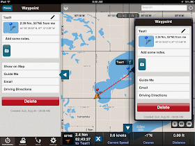
Mark