Thursday, May 30, 2013

HF Weather Fax and Navtex Pad Marine Weather


Application: iPad, iPhone iOS 4.3 or later
Function: High Frequency Weather Fax Data
Rating:****
Cost: $2.99

If your making long distance passages with your yacht your in need of up to date weather information.  Weather is key to timing your travels and staying safe while underway.  Weather information over the radio is not a novel thing. I listen to the radio everyday to get weather forecasts.  But getting a weather fax on my iPad over the radio, now that is almost James Bond cool! 

BlackCat Systems has a variety of apps related to HF marine radio facsimile transmissions that can be received on your yacht with the use of a HF marine radio. Many cruising yachts already have HF SSB radios and rely on them for long distance communication.

Two of their apps caught my eye. One is called HF Weather Fax and the other is Navtex Pad Weather.  The HF Weather Fax app allows you to download radio facsimile graphics to your iPad over a HF marine radio.  This can be done without a cell phone or Internet connection.  These software products have been available for laptop PCs for a while and are now available for your iPad or Android mobile devices too. The Navtex Pad app, shown at left, downloads the marine weather forecast for specific areas.

The HF Weather Fax app also has a built in copy of the NOAA/NWS Radio facsimile schedule along with an option to download the latest copy of the schedule from the NWS website.  This will keep you up to date on the broadcast areas and schedules.

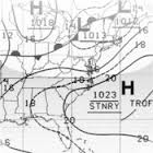
NOAA or the National Oceanic and Atmospheric Administration broadcasts weather fax and forecast data from a variety of locations around the world.  Most of these can be picked up with your SSB radio on board your boat.  Other lower cost portable weather radio options are available too.

Coverage includes broadcast stations in South Africa, Asia, South America, North America, Pan Oceanic Basin and Europe.

How It Works:

Once you open the app it automatically starts trying to decode whatever it is hearing through the audio input or microphone.  The menu at the top includes  selections for Tune, Schedule, Stop, Auto, Save and View Saved.

If you are not ready to decode a fax signal hit the Stop/Start button. The Tune button brings up a display showing you the signal strength of the audio.

The Schedules page is a document from the NOAA/National Weather Service that list the broadcast locations and stations around the world. The broadcast site list their call sign, frequencies, times and power. Schedules are include for each site and the contents of their transmissions. Many include surface analysis, air prognosis, weather bulletins, GOES satellite view, tropical cyclone maps, 24, 36 and 48 hour surface pressures and coastal wave analysis.  Several other products are available depending on which station you connect to.

Tapping the Auto button will change the Auto save mode on and off. When set to Auto, the stop tone of a fax will be used to save the received image.

The Save button can be tapped to manually save an image at any time.

The Download Latest button downloads the newest broadcast schedule to your device. You will need to be connected to the Internet or have a cell connection to download the new schedule.  You can also tap on Default Schedule to erase any downloaded copy, and revert back to the default copy that was provided with the app.

The FAQ section has a lot of good pointers on how to get the app to work the best.

Back on the main page there are buttons to Save and View Saved images.  Tapping on the Save button will archive the current image to the saved directory.  The View Saved button will bring up a list of the saved images. Tap the name of the image and it will be displayed. The option to delete stored images can be done at this time. 

Tips and Tricks:
 
The app picks up the audio from radio fax data broadcast by NOAA and coverts it into images and forecast data.

The app requires that you feed the audio output from your SSB or HF Weather radio into the iPhone or iPad.  There are several ways to accomplish this.

The easiest way is to just set you iPad near the speaker of the radio. This works but any background noise will interferer with the the audio and may cause poor reproduction of the fax data.

You can plug a set of headphone or ear buds into the mic of your iPad and then place these next to the speak of the radio.  This cuts down on some of the back ground noise and works rather well.

Direct connection of into the microphone jack of the iPad is the best way to go. This eliminates all of the back ground noise and produces the best data.  The iPad USB Camera Connection Kit accessory will allow a USB cable to be plugged directly into the iPad.  This is the best solution for eliminating all background noise.

If you don't have an SSB radio other lower cost weather radios will work. Take a look at the authors listing of radios to use with your app and some suggestions on how to choose a radio.

The weather fax frequencies are published in the app.  For best results make sure to tune about 1.9 kHz lower in frequency than the listed carrier frequency.

Your first transmission may seem slightly slanted due to the timing delays between the devices.  This timing can be corrected by adjusting the delay settings which are located at the top of the screen.

The default delay value is zero. If the received image is slanting to the right, the timing adjustment must be increased by pressing the + button. If the received image is slanting to the left, the timing adjustment can be decreased by pressing the - button. Once set the timing adjustment values will be automatically saved and used each time you run the app. 

I really like this app. It does what it is made to do and does it well.  For $2.99 it is a great way to receive valuable weather data at a fraction of the cost of a dedicated weather fax. You don't need a $1000 dollar SSB to receive the signals.  A low cost HF weather radio will work just fine too.

If you sail offshore, an app like this can provide you with much needed weather information to make
a safe passage.  Having another source of weather data can help you make better routing decisions and verify any other forecast you may have.

~~~ Sail On ~~~ /)
Mark


Saturday, May 11, 2013

Electric Pocket's SeaNav

Application: iPhone, 3GS, 4, 4S, 5 and iPad
Function: GPS Charting, planning and navigation app
Rating: ***
Cost: $9.99


The creative folks at Electric Pocket have another great app offering for sailing enthusiasts.  I have previously reviewed their Boat Beacon and Compass Eye apps.  They have built on these apps and expanded their lineup with a new navigation and charting app called SeaNav.  It was just recently released in April in the iTunes Store. They have released two versions of the app. One is for the US coastal waters and includes the Great Lakes and the other is for the UK and Ireland.


SeaNav is a basic planning and real time charting navigation app.  It uses the NOAA vector charts so the all of the United States coastal waters including the Great Lakes can be downloaded for offline use on the device.  When you zoom into an area the charts start to download automatically.  The charts have a very vibrant colorful look to them and include a map, satellite and hybrid versions which also show roadways and a satellite view of nearby land.  You only have to buy the app once and your able to use it on both your iPhone and iPad.  Charts are downloaded on the device and can be used while your out of cell range.

Navigation on the charts includes the usual panning and zooming and multi-touch functions. The vector charts allow the user to display a variety of layers and data about the chart.  Charts are automatically updated through NOAA so you always have the best data.

AIS targets collected through the Internet or your onboard receiver are available as an overlay on the charts.

Features:
  • Route Planning and real time tracking including Waypoints, SOG, COG, ETA, CTE etc.
  • Waypoint
  • Routes
  • Distance and Bearing measuring feature
  • Route export, import and sharing .kmz format.
  • Map, satellite and hybrid displays
  • Charts downloaded and stored on device so they work without mobile coverage!
  • Seamless fast panning and zooming across charts.
  • NOAA Vector Charts
  • Live AIS Ship positions overlaid from Boat Beacon app.
  • Live buoy weather data, Internet required
  • Configurable layers; buoys, lights, depths, rocks, wrecks, anchorage areas etc.
  • Automatic Chart updates

The on screen menu is shown at the bottom of the display.   The Ship icon starts the real time GPS navigation tracking and enables the heads up display. Basic navigation data including latitude, longitude, distance, bearing, course over ground and speed over ground, estimated time of arrival, velocity made good and ETA are provide with the heads up display.  If you have a route or waypoint selected it will give you the distance and bearing to your next waypoint.  The next waypoint in a route can be selected by tapping the forward or backwards arrows. Reverse your route with the two circular arrows in the lower left of the heads up display.

The next Bullseye Eye icon locates your current GPS position and centers it on the chart. 

The Search icon lets you quickly search for any location in the world. Hit search and it displays that position on the chart.

The Compass icon brings up the distance and bearing measuring tool. The green pin is your starting position and the red pin is your ending position. Tap these to move them and measure between any two points. Latitude, longitude, distance and bearing are shown at the bottom of the screen for the two measured points.

The Route icon is next, it lets you add waypoints along with the ability to edit and manage routes on your charts. Tap the Route icon and select New Route, Edit Route or Manage Routes. Select New Route then tap your finger and hold on the chart to start creating waypoints for your route. Continue tapping to add points until your route is complete. Tap and hold any waypoint to reposition it on the chart.  You can rename the route at the bottom of the screen while in Route Edit mode.

Selecting Manage Routes has settings to show, select, edit, delete, rename and share your routes through email. A handy double arrow allows your to reverse the direction of your route.

Setting can be found under the Gear icon. Here you can manage Routes, Map Layer, Charts, and Display Mode.  Advanced settings has a variety of options for charts, units, sounds, power save, safety depth and others.

The last Export icon is for sending your position by email, message or saving the image to your camera roll and printing it.

 
Optional AIS and buoy weather buoy data is available within the app.  To receive AIS data you will have to have the Boat Beacon app installed also.  The AIS position data will be shared from this app.  The Boat Beacon app can be configured to use the data from land based AIS receiving stations.  This data is received on land and re-broadcast over the Internet.  This option requires that you have an internet connection. This AIS data can be added to the chart display under Settings/Manage Map Layers.

The Boat Beacon app can also be configured to use your on board AIS receivers data over a NMEA TCP/IP wireless connection.  These NMEA settings can be setup in the Boat Beacon app under Local AIS Settings. 

The app is a welcome addition to the many charting apps on the market.  The charts are very colorful and incorporate multiple layers which can be turned on or off the de-clutter the display. I liked the map and hybrid versions especially since they show surrounding towns and highways for reference. Whenever you tap on an item on the chart a pop up first tells you what it is. Tapping again provides additional details.

The waypoint and routing function is very easy to use and I found that I could quickly create and edit a route with minimal effort.

The AIS feature is versatile and can be configured to utilize either Internet based data or on board AIS data through the Boat Beacon app.

I had trouble finding the buoy weather data. It would be nice to have a weather icon to select the weather buoys in the immediate area. Other obvious additions would include GRIB weather data, NMEA instrument data, night mode, points of interest, social media posting, anchor alarm and track recording.

I did have the app freeze on me a few times and it did crash on occasion.  I can only hope some optimization can be done to make it more responsive in future versions. The price is comparable to other app with similar features.

This is a great start for Electric Pocket and their SeaNav app.  I look forward to more additions and improvement in future revisions.

~~~ Sail On /)
Mark