Blog Pages

Monday, February 18, 2013

Marine Data to WiFi

The Marine Data Revolution

The world of marine electronics is changing faster than most of us bloggers can write about it. The last few years we have seen the invention of mobile devices, tablets and apps that are revolutionizing the way we share and display marine data.

I normally review marine apps but the hardware that provides the data to these apps is worth taking some time to talk about. Multiplexers and WiFi are making it easier than ever to make data available to anyone on your yacht, anytime and anywhere.

Most yachts today are outfitted with a whole series of marine instruments. These may include wind speed and direction, depth, boat speed, course, heading, AIS, radar and a variety of navigation and weather data.  The smart phone and tablet revolution has created a whole new industry around sharing all of this data with charting, AIS and data apps for mobile devices on your yacht.  These may include a laptop computers, iPhone, iPad or even Android devices.

Sharing Instrument Data

So, what is the best way to get access to all the data on your yacht. Sailors first started incorporating laptop computers with their onboard navigation systems.  In the last 10 years, PC based charting programs became very popular and required access to this instrument data.

This brought about the development and use of multiplexers to connect instrument and GPS data to a laptop. If you still have some older NMEA 0183 instruments or transducers on our yacht, this is still a great way to connect these devices.  

There are several PC programs such as NavMon PC, Polar Navy and GPS Gate that can create virtual serial ports.  Data can then be shared with multiple PC charting programs or with wireless devices through TCP/IP.  An-ad hoc network can also be easily set up with the laptop to share the data with mobile devices.

Serial Data  to WiFi

The next evolutionary step was the development of multiplexers that combined serial NMEA data from yacht instruments and made it available to any WiFi capable device.  This setup omits the need for a computer making the data readily available to any mobile device.

The Digi Wi-SP is a popular model and will efficiently broadcast your instruments NMEA 0183 serial data over WiFi to your iPad, iPhone or Android device. It  can be found for about $270 on various sites.

The cheaper of these options are a couple of  tiny devices called the WiSnap and WiFly serial to WiFi adapters.  These can be powered by battery or hardwired into your 12 volt system using pins 5 and 9 of the serial port.  At $99-$159 these may work well for smaller boat installations where you may only be connecting a single NMEA 0183 devices to the serial port.

Below is a list of serial to WiFi adapters that could be used to broadcast your serial NMEA 0183 data over WiFi. These are very economical and range in price from $100-$300. This list is by no means all inclusive.  Search for "serial to WiFi" in Google to find many more options.

Check out some of the serial to WiFi options available below.

Marine WiFi Multiplexers and NMEA 2000

The NMEA 2000 marine data protocol is the new defined standard and is widely used in the industry.  All new instruments, chartplotters and marine electronics are built using this protocol.  It has an easy plug and play network that can be put together by just about anyone.  Several of the new WiFi multiplexer devices allow the use of both NMEA 0183 and 2000 protocols.  These devices will help bridge the communication gap until the older NMEA 0183 hardware is phased out.


The Vespers Marine XB-8000 combines AIS, GPS, NMEA 0183 and NEMA 2000 data capabilities in one sweet package.  I reviewed this recently in my blog. It is one of the most full featured and will cost you around $800. It also comes with a dedicated Watchmate app.

The devices come with varying specs and data type inputs so make sure you check them all out to determine the right device for you.


Brookhouse has been in the Marine multiplexer game for quite a while. They now offer an iMux which is capable of converting NMEA 0183, GPS and AIS data to WiFi. They are one of a few companies that will convert Raymarine SeaTalk data to WiFi also.

The following is a partial list of dedicated Marine WiFi for AIS, NMEA 0183 and 2000 devices. 

These devices are hardened and built for marine use.  They are designed to be more reliable and stand up to extended use in the harsh marine environment. Select one of these for a more permanent solution on your yacht.


As you can see, there are numerous options out there to fit the needs of just about any application. I could spend hours talking about the many options available, but that would be one boring post.   I hope this list at least gets you thinking about the possibilities of adding WiFi to your yacht.

What multiplexer or WiFi setup are you using? I would love to hear some feedback on some of these units.

~~~ Sail On ~~~ /)
Mark

Friday, February 15, 2013

iSailor 1.5.2 Adds AIS


Application: iPhone, iPad, iPod Touch iOS 4.3
Function: Marine Chart Plotter, GPS tracking, navigation
Rating:****
Cost: App is Free, AIS function $9.99


Transas Marine Limited has a new release 1.5.2 of their iSailor app in the iTunes Apps store.  I first reviewed the app back in January of 2011. They continue to improve the app and have made additions and modifications that make it more useful and enjoyable to use.  The latest version has a few noteworthy features to mention.

New Features:
  • New colored IALA buoys
  • New AIS(Automated Identification System through in app purchase
  • Various bug fixes and improvement
  • TCP/UDP connection options
  • Display AIS targets
  • Display own boats AIS target information
  • Class A and B transponder compatible
  • GPS, course and speed over WiFi
The most notable feature is the new AIS functionality. We are all familiar with AIS and the use of it to view locations and data of other ships.  It can also help you avoid collisions with our vessels.

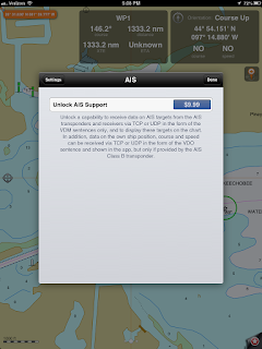
1. To enable the AIS feature in iSailor you must first make an in app purchase for $9.99.  Select the Setting icon in the lower right corner, select AIS, Unlock AIS Support, Buy Now and click OK to confirm the purchase.  

2.  It will also be necessary to have an onboard AIS receiver or transponder capable of sending data over WiFi to the iSailor app on your iPad or iPhone.

3. Next, enable the AIS feature and set up the WiFi source protocol, IP address and port number.  Give this connection a name and save it by selecting the AIS button in the top left of the AIS pop up.  The app will then attempt to connect to the WiFi system at this time.

4. Once connected return to the main chart screen to verify that the AIS targets are showing up.


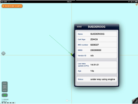
AIS targets will be shown as green triangles with heading vectors. To see additional information about the target, long tap on the screen and then select the target.

Scroll down through the pages of data about the target.

You can display your own yachts position, speed and course data if you have a class B AIS transponder. Select the Use Position from AIS option in the AIS settings options.

AIS is a great feature to have on your yacht if you are sailing in busy ports or shipping channels. It allows you to know what traffic is in the area and what direction and speed they are heading.  I could not determine is the app did any closest point of approach(CPA) or time to closest point of approach(TCPA) calculations. Alarms for possible collisions with other vessels would be a nice feature too.

The iSailor app is free although it appears the add on options for charts and AIS will cost you.  I am not sure I would spend $9.99 on AIS alone.  Their are other apps that include the AIS function for free although the initial app purchase may be higher.  The in app purchase model is a great way to let the users pick which features they want to invest in.  What do you think, is it worth it?

~~~ Sail On ~~~ /)
Mark


Saturday, February 9, 2013

Wiresizer

Application: iPhone, iPad, iPod Touch iOS 5.0
Function: Electrical Wire sizer
Rating: ***
Cost: $0.99

Yachts today are becoming increasingly more complex with the many electronics and systems on board.  Even with all these bells an whistles, there may come a time when you want to add additional equipment.  You may want to add a chartplotter to help you navigate, an VHF radio to communicate, a stereo to help you gyrate or a AIS transponder to keep track of other vessels around you.

If your a "do it your selfer" like me you may want to take on installing some of this equipment your self.  It is not hard to do if you know a few basics.  There are plenty of resources on the internet these days. When in doubt, Google it to find thousands of links to help you out.  YouTube is full of self help and how to videos on just about any subject.  Or, how about an app to help you with your boat wiring project?

Wiresizer is a great little app to help you with some basic electrical installations. It is a must have for your electrical toolbox.  By selecting a few parameters it will provide you with the right size wire for the job. 


Once you have opened the app, select the settings icon in the upper right side of the screen. Here you can set the parameters for measurements and wire sizes.

When you are adding wiring for a new circuit for electrical equipment there are a few things you must consider.  The app takes these into account so all you have to do is select the proper values.   The values can be easily selected by spinning the rollers to the correct value.

First enter the voltage of the circuit. If your working on your boat it will most likely be 12 volts. 

Next, select the current that will be needed to serve the new piece of equipment.  Most equipment will have a power rating in watts. Using the P = VxI formula, where P = watts, V = voltage and I = current we can solve for I = P/V

The last piece of data to enter is the length of the circuit.  This is the distance from your boats breaker panel to and from the new piece of equipment. Use the total round trip distance.

Once all the top settings are selected the app automatically calculates the Minimum Wire Gauge in the bottom section . Various percentages of voltage drops are listed here.

ABYC suggest a 3% voltage drop for critical circuits like electronics and up to 10% voltage drop for non critical circuits like lighting.

If you are going to do any serious wiring on your yacht consider getting a copy of the ABYC electrical standards.  These are the standards used by the marine industry for electrical and other system on your yacht. 

There is a selection at the bottom to determine if the wiring will be inside the engine compartment. The rating will be affected by the added heat from the engine.

Selecting the proper wire size is crucial in safely serving the equipment and preventing overloaded circuits and possible fire.

ENGINE AND ACCESSORY WIRING COLOR CODE from ABYC E11 Table XV
COLOR
ITEM
USE

Yellow w/red stripe (YR) Starting circuit Starting switch to solenoid
Brown/yellow stripe (BY) or
Yellow (Y) - see note
Bilge blowers Fuse or switch to blowers
Dark gray (Gy) Navigation lights
Tachometer
Fuse or switch to lights
Tachometer sender to gauge
Brown (Br) Generator armature
Alternator charge light
Pumps
Generator armature to regulator
Generator
Terminal/alternator
Auxiliary terminal to light to regulator
Fuse or switch to pumps
Orange (O) Accessory feed Ammeter to alternator or generator output and accessory fuses or switches.
Distribution panel to accessory switch
Purple (Pu) Ignition
Instrument feed
Ignition switch to coil and electrical instruments.
Distribution panel to electric instruments
Dark blue Cabin and instrument lights Fuse or switch to lights
Light blue (Lt Bl) Oil pressure Oil pressure sender to gauge
Tan Water temperature Water temperature sender to gauge
Pink (Pk) Fuel gauge Fuel gauge sender to gauge
Green/stripe (G/x)
(Except G/Y)
Tilt down and/or trim in
Tilt and/or trim circuits
Blue/stripe (Bl/x) Tilt up and/or trim out
Tilt and/or trim circuits

The table above is the standard color coding system for marine wiring.  Follow these wire colors to make your project look factory.  Make sure to use only stranded and tinned wire in your marine wiring projects.  Marine wire is specially made to prevent corrosion and stand up to the tough marine environment.

Good luck with your next project!

~~~Sail On~~~ /)
Mark


Sunday, February 3, 2013

iTacTic Tactical Racing App

Application: iPad, iPhone, iPod Touch iOS 6.0
Function: Tactical Sailboat Racing App
Rating: ***
Cost: Free

I am very competitive and if there is any kind of race, I am in it to win. Sailing is no different for me.  If there are two boats on the lake I consider that a race.  I am always looking for a way to gain an edge on my competition.  We have a small yacht club so we only have a few races a year.  The winners get bragging rights until next season, so it is fun to win.  My kids have raced with me for many years and are just as competitive.  Old Vince Lombardi had it right, "winning isn't everything, it is the only thing"!

iTacTic is an app designed to help you win sailing regattas.  It will get you to the start line on time and provide performance data during the race.  After the race you can share the details of your racing tracks with friends.  The app was released in November of 2012, so it is fairly new.  The app is similar in some respects to the iRegatta app that I recently gave an update on.

Features:
  • Multiple Boat parameter profiles
  • Bow Offset
  • Jibe angle
  • Tack angle
  • Background mode of operation
  • Units in meters and feet, knots, m/s, mph,  km/h
  • Default tack and jibe angles
  • GPS precision
  • GPS accuracy
  • Distance to Start line
  • Time to Start line
  • Set Committee boat coordinates
  • Set Pin coordinates
  • Speed over ground SOG
  • Course over ground COG
  • Velocity made good VMG
  • Wind direction setting
  • Adjustable countdown start timer
  • Track recorder
  • Add markers to tracks and map
  • Annotate your tracks
  • Sailing performance
The app is broken down into three sections. The RACE section is used at the start and during the race. The SAILBOAT section is used pre-race to set up the app with your yacht specific parameters. The TRACK section is used post race to review and share your tracks with friends.

 The SAILBOAT section allows you to add specific data to the app about your yacht prior to the race.  This data aids the app in providing optimal performance data to the sailor.  The app needs to know what the bow offset is from the location of your iPhone or iPad. Set the distance in feet or meters from the bow of your boat to the location of your device.

The app also needs to know what your yacht's tack angle is.  This is the totals degrees between starboard and port tack. The value is usually 65 to 90 degrees. 

The jibe angle is the total degrees between one jib and another as shown in the image at to the left.  While making settings, swipe the display to see help screens for explanation of these settings.

Default settings can be made in the iPhone or iPads settings menu. Select the iTacTic icon and make the necessary default settings.

The RACE section is the most extensive and useful during the race. It has three pages of settings and readings to aid you in getting the most out of your yacht during the race. 

The first page provides basic SOG and COG data readings in the center of the screen.  The big digital displays can be easily read. 

On the top of the page are the Velocity Made Good, VMG and performance readings.

VMG is the component of the boats velocity that is made in the direction you are trying to sail.  When you are tacking into the wind this number will be positive and when you are jibing downwind this number will be negative.

The Performance reading measures the current tacking or jibing angle compared to the expected angles that were entered in the SAILBOAT settings.

The next page is used to help with the start of the race.  A handy countdown timer can be set to the desired time until the start of the race. 

The reading at the top shows the Distance to the starting line.  The distance is calculated from the start line coordinates entered on the next page.

The middle reading is the Timer in minutes and seconds.  Time can be added or subtracted from the timer with the buttons at the bottom of the screen.  The start and stop button, located on the bottom center of the screen controls the timer.  Once the timer is started the track recording is also started.

The timer display counts down to zero and then automatically switches to the Course and Speed page for the remainder of the race.

The timer needs to be stopped once your race is over. This will stop the track recording also.

The bottom reading is the Time to start line reading.  The app calculates this with your present SOG and the Distance to the line.

The third RACE display is used to set the wind direction and start line points of reference.

There are four buttons on the bottom of the display. The first button on the left is the pin icon. This is used to set the coordinates of the flag end of the start line. The next button is used to set the coordinates of the committee boat end of the start line.

Wind direction can be set by facing the iPad or iPhone into the wind and tapping the compass rose button at the bottom of the screen.  The wind direction can also be set by tapping the Wind direction and manually entering the data.

Tap the sailboat icon to select your boats preset parameters.

Starboard and port tack headings are shown at the top of the screen.  These are based on the preset tack and jibe angles.  The Compass indication is shown at top right.

The last section is the TRACKS page.  All of your tracks during the races are separately recorded and can be viewed here.  One neat feature is that you can add the start line, marker buoys and other points to the track.

Annotations can be made to the buoys and makers by tapping them. Add a title or subtitle note for a description. The buoys can be deleted here also.

Buoys and markers can me moved after selecting the Modify markers icon in the upper right of the screen.  The bottom icon in this group enables the Drawing feature which allows you to draw freehand on the map.

Use the Export arrow icon in the lower left of the display to share your tracks with friends an family. Export your winning tracks to Facebook, Twitter, email in KML and GPX formats.

Not a bad start for iTacTic 1.0.  I like what I see so far.  Some obvious additions that would make the app more useful would be different display colors for day and night vision, waypoints, wind speed, NMEA data import, NOAA charts and polar diagram integration.

iTacTic has some work ahead of it, but it could become a real contender with die hard sailboat racers like me. 

~~~ Sail On ~~~ /)
Mark