I reviewed the Navionics Mobile app earlier and it looks like they have been busy working with other industry hardware makers to incorporate the ever growing interest in the use of phones and tablets for marine navigation. This trend is only going to continue. Hardware manufacturers can't ignore the popularity of these smart handheld devices and further integration will continue into the marine environment.
Raymarine and Navionics have teamed up to provide a plotter synchronizing feature between the Raymarine G and E series wide screen plotters and the popular Navionics marine charting apps for the iPhone, iPad and iPod touch. The Plotter Sync enables the wireless exchange of navigation data between the two devices.
The Navionics app on your iPad or iPhone can be used while at home to plan your routes and trip. Take it to your yachts and the app will sync the routes and waypoints with your Raymarine G and E series chart plotters. Data such as waypoint locations and route plans can now be instantly synchronized using WiFi technology. Work is continuing to add additional data types to the sync feature.
A standard wireless WiFi router has to be added to the Raymarine G and E series plotters Seatalk interface to allow the two devices to talk to each other. Raymarine shows you how to set up the sync feature on their website shown here www.raymarine.com/plottersync.
Raymarine has also provide a YouTube video showing the functionality of the sync features. See below
Looks like a convenient feature if you have Raymarine products and the Navionics mobile software.
Sunday, February 27, 2011
Friday, February 25, 2011
iRegatta
Application: iPhone, iPad, iPod Touch
Function: Racing Start Timer, Navigation
Cost: $9.99
Rating: ****
 I do a bit of sailboat racing on the the lake I live on in South Dakota. One of the challenges has always been getting to the starting line on time and knowing which end of the line was favored to the wind direction. I have looked at other GPS devices like the Velocitek Prostart but found them too expensive. They never seemed to fit into my meager sailing budget. After a bit of searching I was able to find an app that did exactly what I needed.
I found iRegatta and was excited to give it a try. I downloaded it and found it very easy and intuitive to use. I initially had some problems getting some of the features to work but these issues were cleared up after an email to support on the iRegatta website. The author describes the app as a tactical regatta application for the iPhone, iPad and iPod touch.
The app will work with your iPhone and it's internal GPS. It can also be used in NMEA data mode. This allows the GPS NMEA data to be delivered over WiFi to your iPhone, iPad or iPod touch. This versatility makes it a use full tool for both small and larger yachts. If you have your yachts instruments networked this data can be sent to iRegatta from your laptop with your wireless card.
When the app is fired up the main screen shows a display with a set of four readings. The default data shows Heading , Speed, Wind Direction and Velocity Made Good (VMG). Each of these are editable by tapping and holding your finger on the reading. You can change these four to display any of the dozen or so NMEA data readings. If you want one of the reading to be bigger simply tap the reading you want and it enlarges and reduces the other three readings to a smaller font.

Features:

Tracking can be started by holding your finger on the Tracks button. It will turn from Red to Green and start recording your track.
The Waypoints tab allows you to input waypoints and save them in a list. By holding the Waypoints button down it will also turn from Red to Green and start navigation to a waypoint. The waypoints page shows the waypoint that you are currently navigating to along with bearing and distance.
The Statistics page shows max speed, trip odometer, latitude and longitude. A polar diagram also shows the VMG according to the wind direction. The polar diagram can be enlarged by tapping on it.

The wind tab allows the setting of the wind direction and tack angle. This can be done manually or automatically by sailing on port and starboard tacks and setting the sailing angle.

The Maps tab can show your current location on a map but you need a cell connection or WiFi connection to download the maps in real time.
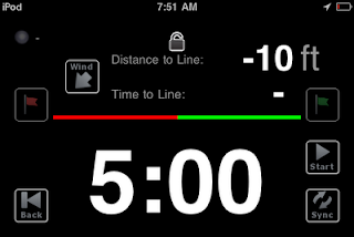
The Timer function is a countdown timer that you can use at the start of the race. It also has other cool features that will give you an edge at the start line. It has incorporated into it a start line function which allows you to set the position of the port and starboard sides of the start line. With the wind direction entered, iRegatta can then calculate the favored side of the start line and show it with a green arrow. The distance and time to the line are also displayed. Once the timer hits zero the main screen is brought up displaying the GPS or NMEA data.
The NMEA data display shows the dozen or so points that can be displayed

The author has done a great job in putting all these functions into a very functional and usefull app. I am looking forward to using iRegatta during our races this summer. I will give you more feedback then. Is there anyone else using iRegatta? I would love to hear from any one who has used it.
Function: Racing Start Timer, Navigation
Cost: $9.99
Rating: ****
I do a bit of sailboat racing on the the lake I live on in South Dakota. One of the challenges has always been getting to the starting line on time and knowing which end of the line was favored to the wind direction. I have looked at other GPS devices like the Velocitek Prostart but found them too expensive. They never seemed to fit into my meager sailing budget. After a bit of searching I was able to find an app that did exactly what I needed. I found iRegatta and was excited to give it a try. I downloaded it and found it very easy and intuitive to use. I initially had some problems getting some of the features to work but these issues were cleared up after an email to support on the iRegatta website. The author describes the app as a tactical regatta application for the iPhone, iPad and iPod touch.
The app will work with your iPhone and it's internal GPS. It can also be used in NMEA data mode. This allows the GPS NMEA data to be delivered over WiFi to your iPhone, iPad or iPod touch. This versatility makes it a use full tool for both small and larger yachts. If you have your yachts instruments networked this data can be sent to iRegatta from your laptop with your wireless card.
When the app is fired up the main screen shows a display with a set of four readings. The default data shows Heading , Speed, Wind Direction and Velocity Made Good (VMG). Each of these are editable by tapping and holding your finger on the reading. You can change these four to display any of the dozen or so NMEA data readings. If you want one of the reading to be bigger simply tap the reading you want and it enlarges and reduces the other three readings to a smaller font.

Features:
- NMEA data display of up to 12 separate data points
- GPS and NMEA data
- Start line setting
- Lift indication
- Distance to start line
- Time to start line
- Charting of Speed and VMG
- Tracking
- Waypoints
- Statistics
- Maps
- Countdown Timer

Tracking can be started by holding your finger on the Tracks button. It will turn from Red to Green and start recording your track.
The Waypoints tab allows you to input waypoints and save them in a list. By holding the Waypoints button down it will also turn from Red to Green and start navigation to a waypoint. The waypoints page shows the waypoint that you are currently navigating to along with bearing and distance.
The Statistics page shows max speed, trip odometer, latitude and longitude. A polar diagram also shows the VMG according to the wind direction. The polar diagram can be enlarged by tapping on it.

The wind tab allows the setting of the wind direction and tack angle. This can be done manually or automatically by sailing on port and starboard tacks and setting the sailing angle.

The Maps tab can show your current location on a map but you need a cell connection or WiFi connection to download the maps in real time.
The Timer function is a countdown timer that you can use at the start of the race. It also has other cool features that will give you an edge at the start line. It has incorporated into it a start line function which allows you to set the position of the port and starboard sides of the start line. With the wind direction entered, iRegatta can then calculate the favored side of the start line and show it with a green arrow. The distance and time to the line are also displayed. Once the timer hits zero the main screen is brought up displaying the GPS or NMEA data.


The author has done a great job in putting all these functions into a very functional and usefull app. I am looking forward to using iRegatta during our races this summer. I will give you more feedback then. Is there anyone else using iRegatta? I would love to hear from any one who has used it.
Sunday, February 13, 2011
NMEA Remote
Application: iPhone, iPad, iPod Touch
Function: NMEA data display
Cost: Lite version $1.99 or full version $7.99
Rating: ****
 I have been looking for the best way to display NMEA data on the iPhone and iPad. I could spend $1100 and get a Maretron NMEA display but that just was not in the budget this year or any year. Being cost conscious and down right cheap I took to searching for an app to do the job.
Here are a few screen shots


I downloaded the lite version but have not extensively used it yet. Is anyone else using the full version?
Function: NMEA data display
Cost: Lite version $1.99 or full version $7.99
Rating: ****
I have been looking for the best way to display NMEA data on the iPhone and iPad. I could spend $1100 and get a Maretron NMEA display but that just was not in the budget this year or any year. Being cost conscious and down right cheap I took to searching for an app to do the job.
NEMAremote caught my eye and seems to do a nice job. Micheal Zapf is the author and he looks to be a sailing enthusiast also. You will need to have your yacht's NMEA data on a network. The app is presently compatible with Seamate 1A Lite, Sailmon and any NMEA/RS232-WiFi bridge. The Digi connect Wi-SP I think would also work. These devices wirelessly transfer your ships network data to your iPhone or iPad. No need for that $1100 dollar display when you already have an iPhone or an iPad.
Features:
NMEA 0183 compatible
Four different color themes, classic, night, silver and amber (shown below)
Data source can be from core locational services or NMEA talker
Units can be switched to English or metric
Eight different displays of NMEA data in the lite version
Supports NMEA sentences GLL, RMC, RMB, VTG, XTE, GSA GSV,VHW,VBW, MWV, VWR, VWT, MTW, DBT, DPT, HDG, HDT.
Supports NMEA sentences GLL, RMC, RMB, VTG, XTE, GSA GSV,VHW,VBW, MWV, VWR, VWT, MTW, DBT, DPT, HDG, HDT.
Data displays GPS lat/lon,
GPS SOG
GPS COG
Satellites in view
Elevation
Boat speed
Boat depth
Apparent Wind
Magnetic and true
VMG
Current speed, max speed,
Log and trip
Here are a few screen shots


I downloaded the lite version but have not extensively used it yet. Is anyone else using the full version?
Subscribe to:
Posts (Atom)